
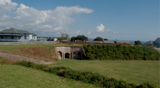
The Second Battle of Fort Fisher was a successful assault by the Union Army, Navy and Marine Corps against Fort Fisher, south of Wilmington, North Carolina, near the end of the American Civil War in January 1865. Sometimes referred to as the "Gibraltar of the South" and the last major coastal stronghold of the Confederacy, Fort Fisher had tremendous strategic value during the war, providing a port for blockade runners supplying the Army of Northern Virginia.
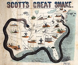
The Anaconda Plan is the name applied to a strategy outlined by the Union Army for suppressing the Confederacy at the beginning of the American Civil War. Proposed by Union General-in-Chief Winfield Scott, the plan emphasized a Union blockade of the Southern ports and called for an advance down the Mississippi River to cut the South in two. Because the blockade would be rather passive, it was widely derided by a vociferous faction of Union generals who wanted a more vigorous prosecution of the war and likened it to the coils of an anaconda suffocating its victim. The snake image caught on, giving the proposal its popular name.

Fort Fisher State Recreation Area is a 287-acre (1.16 km2) North Carolina state park in New Hanover County, North Carolina in the United States. Located near Kure Beach, North Carolina, it includes Fort Fisher, site of a major naval engagement during the American Civil War. The recreation area also served as a home for the Fort Fisher Hermit, Robert Harrill. Harrill lived in a bunker and shared his beliefs about "common sense" with thousands of visitors every year while surviving on what he could gather from the surrounding salt marsh and oyster beds.

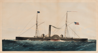
CSS Robert E. Lee was a fast paddle-steamer, originally built as a Glasgow-Belfast packet boat named Giraffe, which was bought as a blockade runner for the Confederate States during the American Civil War, then subsequently served in the United States Navy as USS Fort Donelson and in the Chilean Navy as Concepción.

The First Battle of Fort Fisher was a naval siege in the American Civil War, when the Union tried to capture the fort guarding Wilmington, North Carolina, the South's last major Atlantic port. Led by Major General Benjamin Butler, it lasted from December 23–27, 1864.

The Battle of Wilmington was fought February 11–22, 1865, during the American Civil War, mostly outside the city of Wilmington, North Carolina, between the opposing Union and Confederate Departments of North Carolina. The Union victory in January in the Second Battle of Fort Fisher meant that Wilmington, 30 miles upriver, could no longer be used by the Confederacy as a port. It fell to Union troops after they overcame Confederate defenses along the Cape Fear River south of the city. The Confederate General Braxton Bragg burned stores of tobacco and cotton, among other supplies and equipment, before leaving the city, to prevent the Union from seizing them.

Fort Fisher was a Confederate fort during the American Civil War. It protected the vital trading routes of the port at Wilmington, North Carolina, from 1861 until its capture by the Union in 1865. The fort was located on one of Cape Fear River's two outlets to the Atlantic Ocean on what was then known as Federal Point or Confederate Point and today is known as Pleasure Island. The strength of Fort Fisher led to its being called the Southern Gibraltar and the "Malakoff Tower of the South". The battle of Fort Fisher was the most decisive battle of the Civil War fought in North Carolina.
The Union blockade in the American Civil War was a naval strategy by the United States to prevent the Confederacy from trading.
Wilmington, North Carolina, was a major port for the Confederacy during the American Civil War. It was the last port to fall to the Union Army, completing its blockade of the Atlantic coast.

William Lamb was an American newspaper editor, politician, businessman, and soldier, noted for his role as a Confederate States Army officer in commanding the Confederate garrison at Fort Fisher at the mouth of the Cape Fear River during the Civil War.
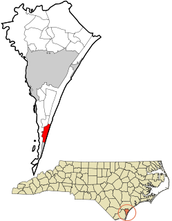
Pleasure Island is a coastal barrier island in Southeastern North Carolina, United States, just south of the City of Wilmington. Pleasure Island is located within Federal Point Township, in New Hanover County. The coastal resort towns of Carolina Beach and Kure Beach, as well as the annexed communities of Wilmington Beach and Hanby Beach are located on the island. The southern end of Pleasure Island was separated from Bald Head Island by Corncake Inlet until the inlet was shoaled and closed in 1998 by Hurricane Bonnie; thus Pleasure Island and Bald Head Island are no longer separate islands.
USS Lenapee (1863) was a steamer acquired by the Union Navy during the American Civil War. She was used by the Navy as a tugboat.

USS Peterhoff was a British ship captured by the Union Navy during the American Civil War. Condemned as a blockade runner, she served the Union Navy's struggle against the Confederate States of America as a gunboat.

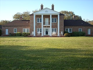
St. Philip's Church, Brunswick Town, is a ruined parish church in Brunswick County, North Carolina, United States. The Anglican church was erected in 1768 and destroyed in 1776. The ruins are located beside the Cape Fear River in the Brunswick Town Historic District, along with Fort Anderson, Russelborough, and the nearby Orton Plantation. Construction lasted 14 years, but took only one day to be destroyed when the British Army burned Brunswick Town. Before its demise, the church was considered one of the finest religious structures in North Carolina. On February 26, 1970, the historic site was added to the National Register of Historic Places.
Brunswick Town was a prominent town in colonial North Carolina. It was the first successful European settlement in the Cape Fear region, a major British port in the 18th century, and home to two provincial governors. Brunswick Town lasted 50 years (1726–1776) until it was raided by the British Army during the American Revolutionary War and never rebuilt. During the American Civil War, 86 years after the town was abandoned, a large portion of the town was covered by earthworks for the construction of Fort Anderson.

The George Davis Monument is a monument to attorney and Confederate politician George Davis that was erected in Wilmington, North Carolina by the United Daughters of the Confederacy. It was removed by the City of Wilmington in August 2021.
This is a list of battles and skirmishes of the American Civil War during the year 1865, the final year of the war. During the year, Union forces were able to capture the last major Confederate ports still open to shipping, along with the Confederate capital, and forced the surrender of the four major Confederate commands.
Fort Johnston was a British fort, later a United States Army post, in Brunswick County, North Carolina on Moore Street near Southport, North Carolina. It stands on the west bank of the Cape Fear River, four miles above its mouth.

The blockade runners of the American Civil War were seagoing steam ships that were used to get through the Union blockade that extended some 3,500 miles (5,600 km) along the Atlantic and Gulf of Mexico coastlines and the lower Mississippi River. The Confederate states were largely without industrial capability and could not provide the quantity of arms and other supplies needed to fight against the industrial north. To meet this need blockade runners were built in Scotland and England and were used to import the guns, ordnance and other supplies that the Confederacy desperately needed, in exchange for cotton that the British textile industry needed greatly. To penetrate the blockade, these relatively lightweight shallow draft ships, mostly built in British ship yards and specially designed for speed but incapable of carrying much cotton, had to cruise undetected, usually at night, through the Union blockade. The typical blockade runners were privately owned vessels often operating with a letter of marque issued by the Confederate States of America. If spotted, the blockade runners would attempt to outmaneuver or simply outrun any Union ships on blockade patrol, often successfully.
Located in North Carolina on the Atlantic Coast, the Fort Caswell Historic District encompasses 2 sites, 43 buildings, and 23 structures; it was added to the National Register of Historic Places in 2013. The fort itself was occupied by various branches of the U.S. armed forces for most of the period between 1836 and 1945 and is now a part of the North Carolina Baptist Assembly, a Christian retreat, owned and operated by the Baptist State Convention of NC. It is accessible by the public to a limited extent per the conditions set forth by the Assembly’s Director.


