Fulton County is located in the north-central portion of the U.S. state of Georgia. As of the 2020 United States census, the population was 1,066,710, making it the state's most-populous county and its only one with over one million inhabitants. Its county seat and largest city is Atlanta, the state capital. Approximately 90% of the City of Atlanta is within Fulton County; the other 10% lies within DeKalb County. Fulton County is part of the Atlanta-Sandy Springs-Roswell, GA Metropolitan Statistical Area.

Coweta County is a county located in the west central portion of the U.S. state of Georgia. It is part of Metro Atlanta. As of the 2010 census, the population was 127,317. The county seat is Newnan.
Carroll County is a county located in the northwestern part of the State of Georgia. As of the 2010 census, its population was approximately 110,527. Its county seat is the city of Carrollton. Carroll County is included in the Atlanta-Sandy Springs-Roswell, GA Metropolitan Statistical Area and is also adjacent to Alabama on its western border.

Sandy Springs is a city in northern Fulton County, Georgia and an inner ring suburb of Atlanta. The city's population was 108,080 at the 2020 census, making it Georgia's seventh-largest city. It is the site of several corporate headquarters, including UPS, Newell Brands, Inspire Brands, Focus Brands, Cox Enterprises, and Mercedes-Benz USA's corporate offices.
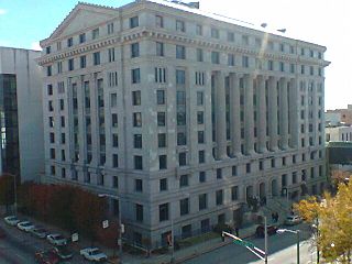
Columbus is a consolidated city-county located on the west-central border of the U.S. state of Georgia. Columbus lies on the Chattahoochee River directly across from Phenix City, Alabama. It is the county seat of Muscogee County, with which it officially merged in 1970. Columbus is the second-largest city in Georgia, and fields the state's fourth-largest metropolitan area. At the 2020 census, Columbus had a population of 206,922, with 328,883 in the Columbus metropolitan area. The metro area joins the nearby Alabama cities of Auburn and Opelika to form the Columbus–Auburn–Opelika Combined Statistical Area, which had an estimated population of 486,645 in 2019.

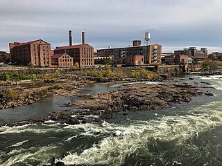
The Chattahoochee River forms the southern half of the Alabama and Georgia border, as well as a portion of the Florida - Georgia border. It is a tributary of the Apalachicola River, a relatively short river formed by the confluence of the Chattahoochee and Flint rivers and emptying from Florida into Apalachicola Bay in the Gulf of Mexico. The Chattahoochee River is about 430 miles (690 km) long. The Chattahoochee, Flint, and Apalachicola rivers together make up the Apalachicola–Chattahoochee–Flint River Basin. The Chattahoochee makes up the largest part of the ACF's drainage basin.

The Ocmulgee River is a western tributary of the Altamaha River, approximately 255 mi (410 km) long, in the U.S. state of Georgia. It is the westernmost major tributary of the Altamaha. It was formerly known by its Hitchiti name of Ocheese Creek, from which the Creek (Muscogee) people derived their name.

Sope Creek is an 11.6-mile-long (18.7 km) stream located in Cobb County, Georgia, United States. It is a significant tributary of the Chattahoochee River. It was known as Soap Creek during the 19th century. A section of Sope Creek runs through the Chattahoochee River National Recreation Area.

The Chattahoochee–Oconee National Forest in northern Georgia comprises two United States National Forests, the Oconee National Forest in eastern Georgia and the Chattahoochee National Forest located in the North Georgia Mountains. The Chattahoochee National Forest is composed of an eastern and western forest. The western forest contains Johns Mountain, Little Sand Mountain, and Taylor Ridge (Georgia). The combined total area of the Chattahoochee–Oconee National Forest is 866,468 acres (3,506 km2), of which the Chattahoochee National Forest comprises 750,145 acres (3,036 km2) and the Oconee National Forest comprises 116,232 acres (470 km2). The county with the largest portion of the eastern forest is Rabun County, Georgia, which has 148,684 acres (601.7 km2) within its boundaries.
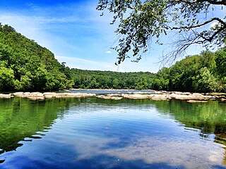
Chattahoochee River National Recreation Area (CRNRA) preserves a series of sites between Atlanta and Lake Sidney Lanier along the Chattahoochee River in Georgia, U.S. The 48-mile (77 km) stretch of the river affords public recreation opportunities and access to historic sites. The national recreation area, a National Park Service unit, was established on August 15, 1978, by President Jimmy Carter.

Johns Creek is a city in Fulton County, Georgia, United States. According to the 2020 census, the population was 82,453. The city is a northeastern suburb of Atlanta.

Chattahoochee Hills is a city in southern Fulton County, Georgia, United States. As of the 2010 census, it had a population of 2,378 living in an area of just over 32,000 acres (130 km2). The population in 2019 was estimated to 3,318 in an area of approximately 37,473 acres (151.65 km2) acres after subsequent annexations. It is the incorporated part of a region called "Chattahoochee Hill Country", an area encompassing approximately 60,000 acres (240 km2) southwest of Atlanta, bordered on the northwest side by the Chattahoochee River. Unlike the rest of metro Atlanta, it is still relatively undeveloped, and most of its rural character remains unchanged. The majority of the wider area comprises the west-southwest part of southern Fulton, and smaller adjacent parts of southern Douglas, eastern Carroll, and northern Coweta counties.
Coleman River is a 6.6-mile-long (10.6 km) stream that is located in the Blue Ridge Mountains, mostly within Rabun County, Georgia. It is one of the main tributaries of the Tallulah River. The headwaters of Coleman River are located in Clay County, North Carolina, and the river travels a short distance before crossing into Georgia. The length of Coleman River in Rabun County is approximately 5.4 miles (8.7 km), with about 1.3 miles (2.1 km) traveling through private lands and about 4.1 miles (6.6 km) traveling through the Chattahoochee National Forest. The northern part of Coleman River in Georgia, from an elevation of about 2,800 feet (850 m) northward, together with the portion of Coleman River in North Carolina, is located in the Southern Nantahala Wilderness.
Apalachicola was the name of a Native American town and chiefdom, and of the people living in it and a group of towns associated with it, located along the lower part of the Chattahoochee River in present-day Alabama and Georgia. The Spanish called the association of towns the Apalachicola Province. It is believed that the residents of all the Apalachicola towns originally spoke Hitchiti, although other towns that spoke Muscogee relocated among the Apalachicolas along the Chattahoochee River in the middle- to later- 17th century. All of the Apalachicola towns moved to central Georgia at the end of the 17th century, where the English called them "Ochese Creek Indians". They moved back to the Chattahoochee River after 1715, with the English then calling them "Lower Creeks".
There were several historic bridges around the metro Atlanta, Georgia area, for which many of its current-day roads are named. Many of them originated as ferries, dating back to the 1820s and 1830s, and carrying travelers across the Chattahoochee River and several other smaller rivers. Several were also covered bridges, very few of which remain as historic sites.
The New River is a 24.5-mile-long (39.4 km) tributary of the Chattahoochee River in Coweta and Heard counties in the U.S. state of Georgia. Rising 4 miles (6 km) south of the city of Newnan, the New River flows generally southwest, reaching the Chattahoochee at West Point Lake approximately 8 miles (13 km) west of Hogansville.
McIntosh Road is a historic Native American route in the northern part of the U.S. states of Alabama and Georgia. It was named for the prominent Creek Indian chief William McIntosh, a leader of the Lower Towns. He helped improve it in the early 19th century, to connect Creek towns in what are now two states.

The Len Foote Hike Inn is a sustainably designed and LEED-certified ecotourism facility located near the peak of Frosty Mountain in the Chattahoochee National Forest in Dawson County, Georgia, USA. The lodge is open year-round and is only accessible via hiking trails. Twenty rooms, a two-story central lobby, a dining room, a bathhouse, toilets, and a common room comprise the facility.
Acorn Creek is a stream in Carroll County in the U.S. state of Georgia, at an elevation of 666 feet (203 m) above mean sea level. It is a tributary to the Chattahoochee River with a discharge rate of 2.74 cfs.
Don Carter State Park is a state park located in Hall County, Georgia, along the shores of Lake Lanier. It is the only state park along the shores of Lake Lanier. The park offers camping, hiking, and access to the adjacent lake, among other amenities. It was officially opened to the public in 2013. As of 2022, it is Georgia's newest state park.

