Chapel Hill, Tennessee

Last updated

Chapel Hill, Tennessee
Chapel hill tn street scene.jpg
Motto: 
Moving forward with strong tradition
Marshall County Tennessee Incorporated and Unincorporated areas Chapel Hill Highlighted 4712880.svg
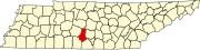
Location of Chapel Hill in Marshall County, Tennessee.
Coordinates: 35°37′41″N86°41′46″W / 35.62806°N 86.69611°W / 35.62806; -86.69611
Country United States
State Tennessee
County Marshall
Settled1808
Incorporated 1849
Government
  TypeMayor and Board of Aldermen
   Mayor Mike Faulkenberry
Area
[1]
  Total3.75 sq mi (9.71 km2)
  Land3.75 sq mi (9.71 km2)
  Water0.00 sq mi (0.00 km2)
Elevation
692 ft (211 m)
Population
 (2020) [2]
  Total1,717
  Density457.87/sq mi (176.79/km2)
Time zone UTC-6 (CST)
  Summer (DST) UTC-5 (CDT)
ZIP code
37034
Area code 931
FIPS code 47-12880 [3]
GNIS feature ID1269440 [4]
Website TownofChapelHillTn.com

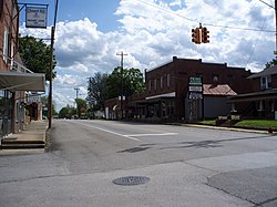
Chapel Hill is a town in northeastern Marshall County, Tennessee, United States. The town was named after Chapel Hill, North Carolina, by settlers from that area. The population was 1,717 as of the 2020 census. [5]

Contents

Geography

Chapel Hill is located at 35°37′41″N86°41′46″W / 35.62806°N 86.69611°W / 35.62806; -86.69611 (35.628154, -86.696203). [6] According to the United States Census Bureau, the town has a total area of 1.4 square miles (3.6 km2), all of it land.

Communities

Nearby cities and towns

Demographics

Historical population
CensusPop.Note
1880 112
1930 377
1940 3913.7%
1950 60354.2%
1960 6304.5%
1970 75219.4%
1980 86114.5%
1990 833−3.3%
2000 94313.2%
2010 1,44553.2%
2020 1,71718.8%
Sources: [7] [8] [2]

2020 census

Chapel Hill racial composition [9]
RaceNumberPercentage
White (non-Hispanic)1,52088.53%
Black or African American (non-Hispanic)643.73%
Native American 50.29%
Other/Mixed 482.8%
Hispanic or Latino 804.66%

As of the 2020 United States census, there were 1,717 people, 660 households, and 396 families residing in the town.

2000 census

As of the census [3] of 2000,[ needs update ] there were 944 people, 398 households, and 278 families residing in the town. The population density was 689.3 inhabitants per square mile (266.1/km2). There were 430 housing units at an average density of 314.1 per square mile (121.3/km2). The racial makeup of the town was 97.7% White, 2.7% African American, 0.5% Native American, 0.6% from other races. Hispanic or Latino of any race were 0.7% of the population.

Chapel Hill Town Hall Chapel hill tn town hall.jpg
Chapel Hill Town Hall

There were 398 households, out of which 31.8% had children under the age of 18 living with them, 55.3% were married couples living together, 10.9% had a female householder with no husband present, and 29.8% were non-families. 27.3% of all households were made up of individuals, and 14.9% had someone living alone who was 65 years of age or older. The average household size was 2.38 and the average family size was 2.88.

In the town, the population was spread out, with 24.2% under the age of 18, 8.6% from 18 to 24, 25.5% from 25 to 44, 24.5% from 45 to 64, and 18.2% who were 65 years of age or older. The median age was 41 years. For every 100 females, there were 90.7 males. For every 100 females age 18 and over, there were 85.2 males.

The median income for a household in the town was $38,173, and the median income for a family was $45,521. Males had a median income of $36,000 versus $24,286 for females. The per capita income for the town was $18,283. About 4.6% of families and 8.1% of the population were below the poverty line, including 11.9% of those under age 18 and 9.5% of those age 65 or over.

Economy

Chapel Hill Post Office Chapel hill tn postoffice.jpg
Chapel Hill Post Office

Utilities

Transportation

Education

K-12

Higher education

Tourism

Henry Horton State Park

Henry Horton State Park is located near Chapel Hill, [10] along the Duck River on the former estate of the late Henry Hollis Horton, 36th governor of Tennessee. The park includes the Buford Ellington Golf Course, hiking trails, playground, cabins, picnic facilities, trap and skeet range, conference facilities, restaurant, and both Olympic-sized and children's swimming pools. Activities also include camping, canoeing, volleyball, disc golf, baseball, basketball, and tennis.

Events

Other points of interest

Notable people

Related Research Articles

<span class="mw-page-title-main">Marshall County, Tennessee</span> County in Tennessee, United States

Marshall County is a county located in the U.S. state of Tennessee. As of the 2020 census, the population was 34,318. Its county seat is Lewisburg. Marshall County comprises the Lewisburg Micropolitan Statistical Area, which is also included in the Nashville-Davidson–Murfreesboro–Franklin, TN Metropolitan Statistical Area. It is in Middle Tennessee, one of the three Grand Divisions of the state.

<span class="mw-page-title-main">Macon County, Tennessee</span> County in Tennessee, United States

Macon County is a county located in the U.S. state of Tennessee As of the 2020 census, the population was 25,216. Its county seat is Lafayette. Macon County is part of the Nashville-Davidson–Murfreesboro–Franklin, TN Metropolitan Statistical Area.

<span class="mw-page-title-main">Coffee County, Tennessee</span> County in Tennessee, United States

Coffee County is a county located in the central part of the state of Tennessee, in the United States. As of the 2020 census, the county's population was 57,889. Its county seat is Manchester. Coffee County is part of the Tullahoma-Manchester, TN Micropolitan Statistical Area. It is also part of Middle Tennessee, one of the three Grand Divisions of the state.

<span class="mw-page-title-main">Mason City, Illinois</span> City in Illinois, United States

Mason City is a city in Mason County, Illinois, United States. The population was 2,077 at the 2020 census, down from 2,343 in 2010.

<span class="mw-page-title-main">Carp Lake Township, Emmet County, Michigan</span> Civil township in Michigan, United States

Carp Lake Township is a civil township of Emmet County in the U.S. state of Michigan. The population was 748 at the 2020 census.

<span class="mw-page-title-main">Melrose, New Mexico</span> Village in New Mexico, United States

Melrose is a village in Curry County, New Mexico, United States. Its population was 651 at the 2010 census. The town is losing population due to rural exodus. Melrose is served by Melrose Elementary School and Melrose High School.

<span class="mw-page-title-main">Arkport, New York</span> Village in New York, United States

Arkport is a village in Steuben County, New York, United States. It is located in the town of Hornellsville, and is north of the city of Hornell. The population was 844 at the 2010 census. The name comes from the barges used to ship products through the village. The postal code is 14807.

<span class="mw-page-title-main">Wartrace, Tennessee</span> Town in Tennessee, United States

Wartrace is a town in Bedford County, Tennessee. The population was 653 at the 2020 census. It is located northeast of Shelbyville. The downtown area is listed on the National Register of Historic Places as the Wartrace Historic District.

<span class="mw-page-title-main">Woodbury, Tennessee</span> Town in Tennessee, United States

Woodbury is a town in Cannon County, Tennessee, United States. Woodbury is part of the Nashville Metropolitan Statistical Area and is located 55 miles (89 km) southeast of downtown Nashville. The population of Woodbury was 2,680 at the 2010 census. It is the county seat of Cannon County.

<span class="mw-page-title-main">Charlotte, Tennessee</span> Town in Tennessee, United States

Charlotte is a town in Dickson County, Tennessee, United States. The population was 1,656 at the 2020 census. It is the county seat of Dickson County. This town is part of the Nashville metropolitan area.

<span class="mw-page-title-main">Moscow, Tennessee</span> City in Tennessee, United States

Moscow is a city in Fayette County, Tennessee, United States. The population was 568 at the 2020 census, 556 at the 2010 census, and 422 at the 2000 census. The town was named after Moskva Russia, by its founder J. A. Dilliard to honor his wife Alexandra a native of Moskva Russia whom he met i on a business trip to Russia in 1834. Moscow, TN maintained close relations with Russia in the years leading to the Civil War, which led to Dilliard’s niece, Lucy Pickens born in LaGrange, TN along with her husband serving as the US ambassador to Russian then after secession serving as Confederate representative to the TSAR during the Civil War. Moscow is also known as the “Land Between Two Rivers,” due to it’s location after the channel was changed The Army Corps of Engineers rerouted the waterways. Moving the main channel west to its current location.

<span class="mw-page-title-main">Decherd, Tennessee</span> City in Tennessee, United States

Decherd is a city in Franklin County, Tennessee, United States. The population was 2,379 at the 2020 census and 2,361 at the 2010 census.

<span class="mw-page-title-main">Ripley, Tennessee</span> City in Tennessee, United States

Ripley is a city in Lauderdale County, Tennessee, United States. The population was 8,445 at the 2010 census. It is the county seat of Lauderdale County.

<span class="mw-page-title-main">Kimball, Tennessee</span> Town in Tennessee, United States

Kimball is a town in Marion County, Tennessee, United States. The population was 1,545 at the 2020 census and 1,395 in 2010. It is part of the Chattanooga, TN–GA Metropolitan Statistical Area.

<span class="mw-page-title-main">Cornersville, Tennessee</span> Town in Tennessee, United States

Cornersville is a town in Marshall County, Tennessee, United States. The population was 1,228 at the 2020 census. The town is home to Cornersville high school.

<span class="mw-page-title-main">Lewisburg, Tennessee</span> City in Tennessee, United States

Lewisburg is a city in and the county seat of Marshall County, Tennessee, United States. The population was 12,288 in 2020. Lewisburg is located in Middle Tennessee, fifty miles south of Nashville and fifty-two miles north of Huntsville, Alabama. Residents have access to the larger cities via nearby I-65.

<span class="mw-page-title-main">Hartsville, Tennessee</span> Consolidated city-county in Tennessee, United States

Hartsville is a town in Trousdale County, Tennessee, United States. It is the county seat of Trousdale County, with which it shares a consolidated city-county government. The population of Hartsville was 11,615 as of 2020.

<span class="mw-page-title-main">Ardmore, Tennessee</span> City in Tennessee, United States

Ardmore is a city in Giles and Lincoln counties, Tennessee, United States. The population was 1,217 at the 2020 census. Ardmore is the site of a Tennessee Department of Tourist Development Welcome Center. It borders its sister city, Ardmore, Alabama.

<span class="mw-page-title-main">Petersburg, Tennessee</span> Town in Tennessee, United States

Petersburg is a town in Lincoln and Marshall counties in the U.S. state of Tennessee. The population was 580 at the 2000 census and 544 at the 2010 census. It used to be the location of Morgan school before consolidation

<span class="mw-page-title-main">Spring Hill, Tennessee</span> City in Tennessee, United States

Spring Hill is a city in Maury and Williamson counties in the U.S. state of Tennessee, located approximately 30 miles (48 km) south of Nashville. Its population as of 2022 is 55,800. Spring Hill is recognized as the 4th fastest growing city in Tennessee by the U.S. Census Bureau and is included in the Nashville metropolitan area.

References

  1. "ArcGIS REST Services Directory". United States Census Bureau. Retrieved October 15, 2022.
  2. 1 2 "Census Population API". United States Census Bureau. Retrieved October 15, 2022.
  3. 1 2 "U.S. Census website". United States Census Bureau . Retrieved January 31, 2008.
  4. "US Board on Geographic Names". United States Geological Survey. October 25, 2007. Retrieved January 31, 2008.
  5. "2020 Population of Tennessee Counties and Incorporated Areas". Tennessee State Data Center. August 12, 2021. Retrieved February 11, 2022.
  6. "US Gazetteer files: 2010, 2000, and 1990". United States Census Bureau. February 12, 2011. Retrieved April 23, 2011.
  7. "Census of Population and Housing: Decennial Censuses". United States Census Bureau . Retrieved March 4, 2012.
  8. "Incorporated Places and Minor Civil Divisions Datasets: Subcounty Resident Population Estimates: April 1, 2010 to July 1, 2012". Population Estimates. U.S. Census Bureau. Archived from the original on June 11, 2013. Retrieved December 11, 2013.
  9. "Explore Census Data". data.census.gov. Retrieved December 25, 2021.
  10. "Henry Horton State Park". Tennessee State Parks . Tennessee.gov. Archived from the original on October 17, 2013. Retrieved January 25, 2014.
  11. "National Register of Historic Places (U.S. National Park Service)". nps.gov. Retrieved February 11, 2022.
  12. "Claude Wilson Osteen (1939-)". Tennessee Encyclopedia of History and Culture . Tennessee Historical Society. Retrieved January 25, 2014.
  13. "Claude Osteen". MLB.com. May 24, 2013. Retrieved January 25, 2014.

35°37′41″N86°41′46″W / 35.628154°N 86.696203°W / 35.628154; -86.696203