College Grove, Tennessee

Last updated

College Grove
College Grove Community Center and R.L. Windrow Gymnasium.JPG
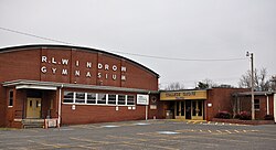
College Grove Community Center and R.L. Windrow Gymnasium, December 2013.
USA Tennessee location map.svg
Red pog.svg
College Grove
Usa edcp location map.svg
Red pog.svg
College Grove
Coordinates: 35°47′15.5″N86°40′30.3″W / 35.787639°N 86.675083°W / 35.787639; -86.675083
Country United States
State Tennessee
Counties Williamson
Elevation
733 ft (223 m)
Time zone UTC-6 (CST)
  Summer (DST) UTC-5 (CDT)
ZIP Code
37046 [1]

College Grove is an unincorporated community near Franklin and Murfreesboro in Williamson County, Tennessee. College Grove is predominantly rural.

Contents

History

Williamson County was founded in 1799, and College Grove was one of its early communities. College Grove gained population during 1880–1920. College Grove includes commercial and rural structures. [2] :3,4,8,9

In the spring of 1861 the Webb Guards company of the Tennessee infantry was raised from the towns of Triune, College Grove, Peytonsville and Bethesda. The company was then organized as Company D of the 20th Tennessee Volunteer Infantry. [3] [2] :24

In the 1880s, College Grove had "100 residents, with three cotton gins, two corn and saw mills, two general stores, and a wagon maker." [2] :29

Landmark buildings

Located in College Grove is the former The Bank of College Grove, whose National Register of Historic Places-listed building now houses a successor national banking institution.

The College Grove Methodist Church is NRHP-listed and is described in the Williamson MRA. [2] :31

Places listed on the National Register in or near College Grove are:

Notable residents

Related Research Articles

<span class="mw-page-title-main">Williamson County, Tennessee</span> County in Tennessee, United States

Williamson County is a county in the U.S. state of Tennessee. As of the 2020 United States census, the population was 247,726. The county seat is Franklin, and the county is located in Middle Tennessee. The county is named after Hugh Williamson, a North Carolina politician who signed the U.S. Constitution. Williamson County is part of the Nashville-Davidson–Murfreesboro–Franklin, TN Metropolitan Statistical Area. In the 19th century, tobacco and hemp were cultivated here, and planters also raised blooded livestock, including horses and cattle.

Burlington is a census-designated place (CDP) in Mineral County, West Virginia, United States, located along U.S. Route 50 where it crosses Pattersons Creek. As of the 2020 census, its population was 131. It is part of the Cumberland, MD-WV Metropolitan Statistical Area. The ZIP code for Burlington is 26710.

<span class="mw-page-title-main">Johnsville, Maryland</span> Unincorporated community in Maryland, U.S.

Johnsville is an unincorporated community in Frederick County, Maryland, United States. It is located approximately halfway between Libertytown and Union Bridge along Maryland Route 75. The Kitterman-Buckey Farm was listed on the National Register of Historic Places in 2005.

<span class="mw-page-title-main">U.S. Route 31A</span> U.S. Highway in Tennessee

U.S. Route 31A is a 76.94-mile-long (123.82 km) alternate route of U.S. Route 31 that exists between Nashville and Pulaski, Tennessee. It is located entirely in Middle Tennessee and except for the Lewisburg bypass, where it is concurrent with SR 106, it is entirely concurrent with unsigned State Route 11.

<span class="mw-page-title-main">The Bank of College Grove</span> United States historic place

The Bank of College Grove in College Grove, Tennessee, opened in a frame building in 1911, and the building was significantly remodelled in 1927, with the exterior gaining a brick veneer and Doric pilasters. The building was listed on the National Register of Historic Places in 1988.

Bethesda, Tennessee is an unincorporated community in rural southeastern Williamson County, Tennessee.

Triune is an unincorporated community in eastern Williamson County, Tennessee, approximately halfway between Franklin and Murfreesboro. The community is located along the Wilson Branch of the Harpeth River. The intersection of former local roads State Route 96 and the concurrency of U.S. Routes 31A and 41A is here. The community is located just north of these roads interchange with Interstate 840.

<span class="mw-page-title-main">College Grove Methodist Church</span> Historic church in Tennessee, United States

The College Grove Methodist Church is a building in College Grove, Tennessee that was listed on the National Register of Historic Places in 1988. It was built c.1888 and was designed and/or built by T.G. Slate.

Allisona is an unincorporated community in Rutherford and Williamson counties, Tennessee.

<span class="mw-page-title-main">Dr. Urban Owen House</span> Historic house in Tennessee, United States

The Dr. Urban Owen House is a property in College Grove, Tennessee that was listed on the National Register of Historic Places in 1988. When listed the property included one contributing building and one non-contributing structure on an area of 2.2 acres (0.89 ha).

The Hartwell B. Hyde House, also known as Solitude, is a property in Triune, Tennessee that was listed on the National Register of Historic Places (NRHP) in 1988.

<span class="mw-page-title-main">Newton Jordan House</span> Historic house in Tennessee, United States

The Newton Jordan House is a property in Triune, Tennessee, United States, that was listed on the National Register of Historic Places in 1988. It was built, remodelled, or has other significance in c. 1830 and c. 1900. It includes Central passage plan and other architecture. When listed the property included three contributing buildings on an area of 1 acre (0.40 ha).

The Jacob Critz House is a c. 1835 center-hall house in Thompson's Station, Tennessee, United States. It was listed on the National Register of Historic Places in 1988. When listed the property included one contributing building, one non-contributing building, and one non-contributing structure, on 1.7 acres (0.69 ha). The property was covered in a 1988 study of Williamson County historical resources.

<span class="mw-page-title-main">James Scales House</span> Historic house in Tennessee, United States

The James Scales House, built c. 1885 in Kirkland, Tennessee, United States, along with the William W. Johnson House, another Williamson County house, are notable as late 19th century central passage plan residences that "display period decoration at eaves and porch." It includes Stick/Eastlake, I-house, and central passage plan architecture.

The John S. Russwurm House is a house with Federal architecture, dating from 1819, in Triune, Tennessee that was listed on the National Register of Historic Places in 1988.

The Joseph Scales House is a property in Triune, Tennessee, United States, that was listed on the National Register of Historic Places in 1988, and delisted in 2022. It dates from c. 1845. It includes Central passage plan and other architecture. When listed the property included four contributing buildings, and three contributing structures on 92 acres (37 ha). The NRHP eligibility for the property was addressed in a 1988 study of Williamson County historical resources.

<span class="mw-page-title-main">Abram Glenn House</span> Historic house in Tennessee, United States

The Abram Glenn House is a property in Triune, Tennessee that was listed on the National Register of Historic Places in 1988. It dates from c.1815.

The James Webb House is a property in Triune, Tennessee that dates from c.1850 and that was listed on the National Register of Historic Places (NRHP) in 1988. It has also been known as Kirkview Farm.

<span class="mw-page-title-main">Tennessee State Route 16</span> State highway in Tennessee, United States

State Route 16 is a state highway in the U.S. state of Tennessee. Its southern terminus is at the Alabama state line, where it continues as State Route 79 in Alabama. From there, it continues to Winchester, where it becomes unsigned in a concurrency with U.S. Route 41A. This concurrency lasts until its northern terminus in Williamson County, at a junction with U.S. Route 31A.

<span class="mw-page-title-main">U.S. Route 41 Alternate (Tennessee–Kentucky)</span> U.S. Highway in Tennessee and Kentucky

U.S. Route 41 Alternate, also signed U.S. Route 41A in Tennessee (US 41A), connects the town of Monteagle, Tennessee, with Hopkinsville, Kentucky, 10 miles (16 km) north of the Tennessee line. It serves the city of Clarksville, Tennessee, on its way to Nashville, where it briefly runs concurrently with US 41. It then separates again to serve Shelbyville, Winchester, and Tullahoma before rejoining the main route atop Monteagle Mountain. US 41A runs west of US 41 for its entire length, aside from one mile in downtown Nashville where they are concurrent. US 41A is also concurrent with U.S. Route 31A from Nashville to Triune, Tennessee, for a distance of approximately 25 miles (40 km).

References

  1. "Zip Code 37046 Map and Profile". zipdatamaps.com. 2022. Retrieved November 1, 2022.
  2. 1 2 3 4 Thomason Associates and Tennessee Historical Commission (February 1988). "Historic Resources of Williamson County (Partial Inventory of Historic and Architectural Properties), National Register of Historic Places Inventory Nomination". National Park Service.
  3. 1 2 McMurray, W J (1904). History of the Twentieth Tennessee Regiment Volunteer Infantry, C.S.A. Tennessee: Publication Committee. p.  103.
  4. "Business Page on opencorporates". opencorporates.com. Retrieved March 18, 2023.