Lillard Mill, Tennessee

Last updated

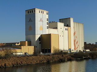
Lillard Mill is an extinct town in Marshall County, in the U.S. state of Tennessee. The GNIS classifies it as a populated place. [1]

Marshall County, Tennessee County in the United States

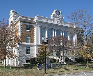
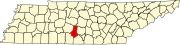
Marshall County is a county located in the U.S. state of Tennessee. As of the 2010 census, the population was 30,617. Its county seat is Lewisburg.

U.S. state constituent political entity of the United States

In the United States, a state is a constituent political entity, of which there are currently 50. Bound together in a political union, each state holds governmental jurisdiction over a separate and defined geographic territory and shares its sovereignty with the federal government. Due to this shared sovereignty, Americans are citizens both of the federal republic and of the state in which they reside. State citizenship and residency are flexible, and no government approval is required to move between states, except for persons restricted by certain types of court orders. Four states use the term commonwealth rather than state in their full official names.

Tennessee State of the United States of America

Tennessee is a state located in the southeastern region of the United States. Tennessee is the 36th largest and the 16th most populous of the 50 United States. Tennessee is bordered by Kentucky to the north, Virginia to the northeast, North Carolina to the east, Georgia, Alabama, and Mississippi to the south, Arkansas to the west, and Missouri to the northwest. The Appalachian Mountains dominate the eastern part of the state, and the Mississippi River forms the state's western border. Nashville is the state's capital and largest city, with a 2017 population of 667,560 and a 2017 metro population of 1,903,045. Tennessee's second largest city is Memphis, which had a population of 652,236 in 2017.

History

A variant name was "Lillards Mills". [1] The community once had Lilliard's Mill, a gristmill. [2] A post office called Lillard's Mill was established in 1866, and remained in operation until 1914. [3]

Gristmill mill; grinds grain into flour

A gristmill grinds cereal grain into flour and middlings. The term can refer to both the grinding mechanism and the building that holds it.

Related Research Articles

Dundee, Ohio census-designated place in Ohio, United States

Dundee is a census-designated place in central Wayne Township, Tuscarawas County, Ohio, United States. Although it is unincorporated, it has a post office, with the ZIP code of 44624. It lies at the intersection of State Routes 93 and 516.

Noah, Tennessee human settlement in Tennessee, United States of America

Noah is an unincorporated community in Coffee County, Tennessee. In 1887 it was described as being 8.5 miles (13.7 km) north of the county seat of Manchester and having a population between 50 and 100. Noah is believed to be the first settlement in Coffee County, having been settled on the Noah Fork of the Duck River about 1800 by the Patton Brothers, John, Daniel, and Neely.

Denmark, Ohio human settlement in Morrow County, Ohio, United States of America

Denmark is an unincorporated community in Morrow County, in the U.S. state of Ohio.

Petersburg is an unincorporated community in Gordon County, in the U.S. state of Georgia.

South Plymouth is an unincorporated community in Fayette County, in the U.S. state of Ohio.

Risner is an unincorporated community in Floyd County, in the U.S. state of Kentucky.

Cainsville is an unincorporated community in Wilson County, in the U.S. state of Tennessee.

Greenvale is an unincorporated community in Wilson County, in the U.S. state of Tennessee.

Salem is an unincorporated community in Rutherford County, in the U.S. state of Tennessee.

Versailles is an unincorporated community in Rutherford County, in the U.S. state of Tennessee.

Florence is an unincorporated community in Rutherford County, in the U.S. state of Tennessee.

Verona is an unincorporated community in Marshall County, in the U.S. state of Tennessee.

Mooresville is an unincorporated community in Marshall County, in the U.S. state of Tennessee.

Silver Creek is an unincorporated community in Marshall and Maury counties, in the U.S. state of Tennessee. A variant name was "Silvercreek".

Rich Creek is an unincorporated community in Marshall County, in the U.S. state of Tennessee. A variant name was "Richcreek".

Cochran is an unincorporated community in Marshall County, in the U.S. state of Tennessee.

Lunns Store is an unincorporated community in Marshall County, in the U.S. state of Tennessee. A variant name was "Lunn Store".

Beasley is an unincorporated community in Marshall County, in the U.S. state of Tennessee.

Delina is an unincorporated community in Marshall County, in the U.S. state of Tennessee.

Skeels is an unincorporated community in Gladwin County, in the U.S. state of Michigan.

References

  1. 1 2 U.S. Geological Survey Geographic Names Information System: Lillard Mill
  2. History of Tennessee from the Earliest Time to the Present. Goodspeed Publishing Company. 1886. p. 899.
  3. "Post Offices". Jim Forte Postal History. Retrieved 18 June 2017.

Coordinates: 35°35′12″N86°47′05″W / 35.58667°N 86.78472°W / 35.58667; -86.78472

Geographic coordinate system Coordinate system

A geographic coordinate system is a coordinate system that enables every location on Earth to be specified by a set of numbers, letters or symbols. The coordinates are often chosen such that one of the numbers represents a vertical position and two or three of the numbers represent a horizontal position; alternatively, a geographic position may be expressed in a combined three-dimensional Cartesian vector. A common choice of coordinates is latitude, longitude and elevation. To specify a location on a plane requires a map projection.