Smyrna, Tennessee

Last updated

Smyrna, Tennessee
Smyrna town hall.JPG
Smyrna Town Hall, July 2014
Williamson County Tennessee Incorporated and Unincorporated areas Smyrna Highlighted 4769420.svg
Location of Smyrna in Rutherford County, Tennessee.
Coordinates: 35°58′46″N86°31′16″W / 35.97944°N 86.52111°W / 35.97944; -86.52111
Country United States
State Tennessee
County Rutherford
Founded1855 [1]
Incorporated1869 [2]
Named for Ancient Smyrna [1]
Area
[3]
  Total34.01 sq mi (88.09 km2)
  Land33.91 sq mi (87.83 km2)
  Water0.10 sq mi (0.26 km2)
Elevation
545 ft (166 m)
Population
 (2020) [4]
  Total53,070
  Density1,564.98/sq mi (604.24/km2)
Time zone UTC-6 (Central (CST))
  Summer (DST) UTC-5 (CDT)
ZIP code
37167
Area code 615
FIPS code 47-69420
GNIS feature ID1270735 [5]
Website Town of Smyrna

Smyrna is a town in Rutherford County, Tennessee. Smyrna's population was 53,070 at the 2020 census, [6] making it the largest town in Tennessee by population in that census. In 2007, U.S. News & World Report listed Smyrna as one of the best places in the United States to retire. [7] Smyrna is part of the Nashville metropolitan statistical area.

Contents

History

Sam Davis House Sam Davis House.jpg
Sam Davis House

The town of Smyrna has its European American roots in the early 19th century and began as an agrarian community. It was important during the Civil War because its railroad station lies between Nashville and Chattanooga. One of the major events of the war for the town involved the Confederate States soldier Sam Davis, who, after being charged with spying, gave up his life instead of giving any information to the Union Army. He was captured November 20, 1863, and was hanged by Union forces on November 27 of that year. [8] The Sam Davis Plantation, located on 160 acres (0.65 km2) of well-maintained farmland, is the town's most important historical site. [9] [10]

Smyrna was originally incorporated in 1869 but its charter was rescinded by the state several years later. In 1915, the town re-incorporated and adopted a commission-mayor form of government.

In 1941 during World War II, Sewart Air Force Base was established here and served as a B-17 Flying Fortress and B-24 advanced training facility. During the 1950s and 1960s, the military personnel and dependents totaled more than 10,000 persons stationed at the base. The base was scheduled for closing in 1971. Most of the property was divided among the State of Tennessee, Rutherford County, and the Metropolitan Nashville Airport Authority. On its portion, the state opened and operates a Tennessee Army National Guard base and the Tennessee Rehabilitation Center. Much of the additional land was developed as the Smyrna/Rutherford County Airport Authority in 1990. [10]

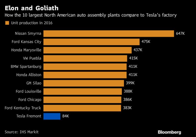
During the 1970s, many new industries moved to the area. The city began a period of growth stimulated by production of such companies as Better Built Aluminum, Cumberland Swan (currently known as Vi-Jon, Inc.), and Square D building plants. In the early 1980s, Nissan Motors constructed a manufacturing plant in the city, and in 1983, the first vehicle was produced. [11] The Nissan plant now employs around 8,400 workers, [12] has a production capacity of 640,000 vehicles annually, [12] and covers an area of 5,200,000 sq ft (480,000 m2). [13] In 2012, Smyrna began manufacturing Nissan's electric car, the Nissan Leaf, and its batteries. [14]

On March 14, 2000, the mayor and board of commissioners adopted a new charter. The city now operates under the city manager form of government, whereby the commissioners hire a city manager for daily operations. [10]

On June 2, 2016 Blue Angels #6 crashed in Smyrna when practicing for the Great Tennessee Air show, killing pilot Capt. Jeff Kuss, USMC. [15] The people of Smyrna raised funds to have a memorial built in his honor. The Capt. Jeff Kuss USMC Memorial sits across from the Smyrna Airport, where Capt. Kuss departed on his tragic final flight, and the centerpiece is a retired F/A-18 Hornet loaned to Smyrna from the United States Navy, painted in the colors of the Blue Angels performance squadron with Capt. Kuss' name under the cockpit hatch and the number 6 on the tails to represent which plane he flew on his final flight.

Geography

According to the United States Census Bureau, the town has a total area of 23.0 square miles (60 km2), of which 22.8 square miles (59 km2) is land and 0.1 square miles (0.26 km2) (0.61%) is water.

Portions of the Percy Priest Lake reservoir lies within the town limits. The two main waterways are Stones River and Stewarts Creek.

Demographics

Historical population
CensusPop.Note
1880 215
1920 463
1930 53114.7%
1940 493−7.2%
1950 1,544213.2%
1960 3,612133.9%
1970 5,69857.8%
1980 8,83955.1%
1990 13,64754.4%
2000 25,56987.4%
2010 39,97456.3%
2020 53,07032.8%
U.S. Decennial Census [16]
[4]

2020 census

Smyrna racial composition [17]
RaceNumberPercentage
White (non-Hispanic)29,72856.02%
Black or African American (non-Hispanic)8,55416.12%
Native American 800.15%
Asian 3,0635.77%
Pacific Islander 550.1%
Other/Mixed 2,6034.9%
Hispanic or Latino 8,98816.94%

As of the 2020 United States census, there were 53,070 people, 18,059 households, and 12,282 families residing in the town.

2010 census

As of the census of 2010, [18] there were 39,974 people, 14,807 households, and 10,509 families living in the city. The population density was 1,753.25 persons per square mile, and the housing unit density was 649.43 units per square mile. The racial makeup of the city was 75.00% White, 11.21% Black or African American, 4.35% Asian, 0.59% Native American, 0.08% Pacific Islander, 6.02% from other races, and 2.75% from two or more races. Those of Hispanic or Latino origins constituted 10.72% of the population.

Of the 14,807 households, 37.23% had children under the age of 18 living in them, 50.46% were married couples living together, 5.54% had a male householder with no wife present, 14.98% had a female householder with no husband present, and 29.03% were non-families. 23.03% of all households were made up of individuals, and 5.94% had someone living alone who was 65 years of age or older. The average household size was 2.68 and the average family size was 3.15.

Of the 39,974 people living in the city, 27.89% were under the age of 18, 63.50% were between the ages of 18 and 64, and 8.60% were 65 years of age or older. The median age was 33.0 years. 51.32% of all persons were female and 48.68% were male.

The median household income in the city was $51,505, and the median family income was $61,286. Males had a median income of $43,633 versus $37,029 for females. The per capita income for the city was $24,448. About 9.4% of families and 12.2% of the population were below the poverty line, including 18.3% of those under the age of 18 and 7.4% of those age 65 and over.

2000 census

As of the census [19] of 2000, there were 25,569 people, 9,608 households, and 7,061 families living in the town. The population density was 1,119.8 inhabitants per square mile (432.4/km2). There were 10,016 housing units at an average density of 438.6 per square mile (169.3/km2). The racial makeup of the town was 87.23% White, 7.82% African American, 0.29% Native American, 1.21% Asian, 0.08% Pacific Islander, 1.81% from other races, and 1.56% from two or more races. Hispanic or Latino of any race were 4.31% of the population.

There were 9,608 households, out of which 39.8% had children under the age of 18 living with them, 55.0% were married couples living together, 14.2% had a female householder with no husband present, and 26.5% were non-families. 21.1% of all households were made up of individuals, and 4.3% had someone living alone who was 65 years of age or older. The average household size was 2.62 and the average family size was 3.04.

In the town, the population was spread out, with 27.6% under the age of 18, 10.5% from 18 to 24, 35.1% from 25 to 44, 19.9% from 45 to 64, and 6.8% who were 65 years of age or older. The median age was 32 years. For every 100 females, there were 95.9 males. For every 100 females age 18 and over, there were 92.9 males.

The median income for a household in the town was $44,405, and the median income for a family was $51,550. Males had a median income of $37,130 versus $27,325 for females. The per capita income for the town was $19,704. About 6.7% of families and 8.8% of the population were below the poverty line, including 11.4% of those under age 18 and 8.2% of those age 65 or over.

Economy

The Nissan Smyrna Assembly Plant is the largest automotive assembly plant in the US, making 640,000 cars per year. It began in 1983, and has made more than 10 million cars since then. Manufacturing of batteries for the Leaf began at the site in 2012. [20] [21] [22] Nissan's goal is that the plant in Smyrna will eventually produce 150,000 electric cars, and 200,000 electric car batteries per year. [23] In addition to serving as the U.S. production site for the Leaf, the plant assembles five other models.

The top employers in the city are: [24]

Prior to their dissolution, RegionsAir (formerly Corporate Airlines) and Capitol Air were headquartered in Smyrna.

Parks and recreation

Smyrna has 10 parks, a public golf course, 7 miles of greenway trails and an outdoor water park. [7]

Education

Smyrna is served by the Rutherford County Schools school district. [25]

Public schools

Private schools

Notable people

Sister City

Government

Past mayors

Related Research Articles

<span class="mw-page-title-main">Rutherford County, Tennessee</span> County in Tennessee, United States

Rutherford County is a county located in the U.S. state of Tennessee. It is located in Middle Tennessee. As of a 2021 estimate, the population was 352,182, making it the fifth-most populous county in Tennessee. A study conducted by the University of Tennessee projects Rutherford County to become the third largest county in Tennessee by population by 2050. Its county seat is Murfreesboro, which is also the geographic center of Tennessee. As of 2010, it is the center of population of Tennessee. Rutherford County is included in the Nashville-Davidson–Murfreesboro–Franklin, TN Metropolitan Statistical Area.

<span class="mw-page-title-main">Loudon County, Tennessee</span> County in Tennessee, United States

Loudon County is a county in the U.S. state of Tennessee. It is located in the central part of East Tennessee. As of the 2020 census, the population was 54,886. Its county seat is Loudon. Loudon County is included in the Knoxville, TN Metropolitan Statistical Area.

<span class="mw-page-title-main">Cannon County, Tennessee</span> County in Tennessee, United States

Cannon County is a county located in the U.S. state of Tennessee. As of the 2020 census, the population was 14,506. Its county seat is Woodbury. Cannon County is part of the Nashville–Davidson–Murfreesboro–Franklin, TN Metropolitan Statistical Area.

<span class="mw-page-title-main">New Market, Alabama</span> Census-designated place in Alabama, United States

New Market is an unincorporated community and census-designated place (CDP) in Madison County, Alabama, United States, and is included in the Huntsville-Decatur Combined Statistical Area. As of the 2020 census, the population of the CDP was 1,543. Although it was the first area settled in Madison County, the town has never been incorporated.

<span class="mw-page-title-main">Overland, Missouri</span> City in Missouri, United States

Overland is a city in St. Louis County, Missouri, United States. The population was 16,062 at the 2010 census.

<span class="mw-page-title-main">Pleasant View, Tennessee</span> City in Tennessee, United States

Pleasant View is a city on the northern border of Cheatham County. Located in Middle Tennessee, it is part of the Nashville-Davidson–Murfreesboro–Franklin, TN Metropolitan Statistical Area. As of the 2020 census, the city's population was 4,807.

<span class="mw-page-title-main">Decherd, Tennessee</span> City in Tennessee, United States

Decherd is a city in Franklin County, Tennessee, United States. The population was 2,379 at the 2020 census and 2,361 at the 2010 census.

<span class="mw-page-title-main">Lawrenceburg, Tennessee</span> City in Tennessee, United States

The city of Lawrenceburg is the county seat of Lawrence County, Tennessee, United States, The largest city on the state's southern border between Chattanooga and Memphis, it lies on the banks of Shoal Creek. The population was 11,633 at the 2020 United States Census. The city is named after War of 1812 American Navy officer James Lawrence.

<span class="mw-page-title-main">Etowah, Tennessee</span> City in McMinn County, Tennessee, United States

Etowah is a city in McMinn County in the U.S. state of Tennessee. The population was 3,613 at the 2020 census.

<span class="mw-page-title-main">Tellico Plains, Tennessee</span> Town in Tennessee, United States

Tellico Plains is a town in Monroe County, Tennessee, United States. The population was 859 at the 2000 census and 880 at the 2010 census. Tellico Plains is home to several communities that include Coker Creek, Belltown, Rafter, Mount Vernon, Rural Vale, and more.

<span class="mw-page-title-main">Dayton, Tennessee</span> City in Tennessee, United States

Dayton is a city in and the county seat of Rhea County, Tennessee, United States. As of the 2020 census, the city population was 7,065. The Dayton Urban Cluster, which includes developed areas adjacent to the city and extends south to Graysville.

<span class="mw-page-title-main">Spring City, Tennessee</span> Town in Tennessee, United States

Spring City is a town in Rhea County, Tennessee, United States. The population was 1,949 at the 2020 census and 1,981 at the 2010 census. The town is located along Watts Bar Lake, and Watts Bar Dam and the Watts Bar Nuclear Generating Station are nearby.

<span class="mw-page-title-main">La Vergne, Tennessee</span> City in Tennessee, United States

La Vergne is a city in Rutherford County, Tennessee, United States. The population was 38,719 at the 2020 census. La Vergne lies within the Nashville Metropolitan Statistical Area.

<span class="mw-page-title-main">Lebanon, Tennessee</span> City in Tennessee, United States

Lebanon is the county seat of Wilson County, Tennessee, United States. The population was 38,431 at the 2020 census. Lebanon is located in Middle Tennessee, approximately 25 miles (40 km) east of downtown Nashville. Lebanon is part of the Nashville Metropolitan Statistical Area.

<span class="mw-page-title-main">Goodlettsville, Tennessee</span> City in Tennessee, United States

Goodlettsville is a city in Davidson and Sumner counties in the U.S. state of Tennessee. It was incorporated as a city in 1958 with a population of just over 3,000 residents; in 2020, the population was 17,789. It is part of the Nashville metropolitan area.

<span class="mw-page-title-main">Tennessee Ridge, Tennessee</span> Town in Tennessee, United States

Tennessee Ridge is a town in Houston and Stewart counties in the U.S. state of Tennessee. The population was 1,332 at the 2020 census and 1,368 at the 2010 census.

<span class="mw-page-title-main">Spring Hill, Tennessee</span> City in Tennessee, United States

Spring Hill is a city in Maury and Williamson counties in the U.S. state of Tennessee, located approximately 30 miles (48 km) south of Nashville. Its population as of 2022 is 55,800. Spring Hill is recognized as the 4th fastest growing city in Tennessee by the U.S. Census Bureau and is included in the Nashville metropolitan area.

<span class="mw-page-title-main">White House, Tennessee</span> City in Tennessee, United States

White House is a city in Robertson and Sumner counties in the United States state of Tennessee. The population was listed as 12,982 in the 2020 census. It is approximately twenty-two miles north of downtown Nashville.

<span class="mw-page-title-main">Smyrna, New York</span> Town in New York, United States

Smyrna is a town in Chenango County, New York, United States. The population was 1,280 at the 2010 census. Smyrna is named after a coastal city in ancient Greece, nowadays modern Izmir in Turkey.

<span class="mw-page-title-main">Smyrna Airport (Tennessee)</span> Airport in Smyrna, TN, US

Smyrna Airport is a public general aviation and military use airport located two nautical miles (4 km) north of the central business district of Smyrna, a town in Rutherford County, Tennessee, United States. It is owned by the Smyrna / Rutherford County Airport Authority. Smyrna Airport is the third largest airport in Tennessee and is the state's busiest general aviation airport. Prior to March 1971, the facility was an active military installation known as Sewart Air Force Base.

References

  1. 1 2 Walter Hoover, "Footprints in the Mud and Dust at Smyrna, Tennessee," 1982. Retrieved: February 7, 2013.
  2. Tennessee Blue Book 2021-2022 (PDF). Tennessee Secretary of State. 2021. pp. 870–874. Retrieved April 14, 2022.
  3. "ArcGIS REST Services Directory". United States Census Bureau. Retrieved October 15, 2022.
  4. 1 2 "Census Population API". United States Census Bureau. Retrieved October 15, 2022.
  5. "US Board on Geographic Names". United States Geological Survey. October 25, 2007. Retrieved January 31, 2008.
  6. "Smyrna (Town) QuickFacts from the US Census Bureau". Archived from the original on March 4, 2012. Retrieved March 3, 2012.
  7. 1 2 Emily Brandon (September 20, 2007). "Best Places to Retire: Smyrna, Tennessee". U.S. News & World Report. Retrieved February 10, 2013.
  8. "History" Archived October 18, 2013, at the Wayback Machine , Sam Davis website
  9. "The Historic Sam Davis Home and Plantation: A Nonprofit Organization". The Historic Sam Davis Home and Plantation: A Nonprofit Organization.
  10. 1 2 3 "History" Archived January 4, 2004, at archive.today , Town of Smyrna website
  11. Peter J. Boyer (April 27, 2009), "The Road Ahead: Smyrna, Tennessee, vs. Detroit", The New Yorker
  12. 1 2 3 "INFOGRAPHIC: Nissan Manufacturing in Tennessee - Nissan Smyrna Manufacturing and Assembly Plant". Nissan Smyrna Manufacturing and Assembly Plant. October 6, 2016. Archived from the original on February 18, 2017. Retrieved December 12, 2016.
  13. "About: Careers" Archived February 25, 2010, at the Wayback Machine , Nissan USA
  14. [ dead link ]
  15. "Capt. Jeff Kuss USMC Memorial | Capt. Jeff Kuss USMC Memorial".
  16. United States Census Bureau. "Census of Population and Housing" . Retrieved November 6, 2014.
  17. "Explore Census Data". data.census.gov. Retrieved December 26, 2021.
  18. "Smyrna town, Tennessee". United States Census Bureau . 2010. Retrieved December 29, 2019.
  19. "U.S. Census website". United States Census Bureau . Retrieved January 31, 2008.
  20. "FACT SHEET: Vehicle Assembly Plant and Battery Plant - Smyrna, Tennessee - Nissan Smyrna Manufacturing and Assembly Plant". Nissan. April 2017. Archived from the original on October 27, 2017. Retrieved October 27, 2017.
  21. "About Nissan - Nissan Smyrna Manufacturing and Assembly Plant (Videos)". Archived from the original on October 26, 2017. Retrieved October 27, 2017.
  22. Top10 US car factories Bloomberg
  23. "US Department of Energy on Nissan Leaf plans in Smyrna". Archived from the original on August 3, 2011. Retrieved June 25, 2017.
  24. [ permanent dead link ]
  25. Archived November 15, 2012, at the Wayback Machine , Rutherford County Schools
  26. "The Father of all Mayors". December 28, 2015.
  27. "Publication". Rutherford County Historical Society. June 7, 1982 via Internet Archive.
  28. "Smyrna's father of all mayors". DNJ.
  29. "Remembering Rutherford: Sam Ridley ouster verdict changed little in Smyrna". June 14, 2015.
  30. 1 2 "Town Parks & Facilities | Smyrna, TN". www.townofsmyrna.org.
  31. "Chamber to honor former mayor Spivey". The Murfreesboro Post.
  32. "Smyrna Mayor Tony Dover Resigns... Why?". Murfreesboro News and Radio. August 29, 2013.
  33. "Politics: Reed Announces Bid for Smyrna Mayor". Murfreesboro News and Radio. August 25, 2014.