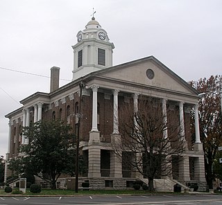
Wilson County is a county located in the U.S. state of Tennessee. As of the 2010 census, the population was 113,993. Its county seat is Lebanon. The largest city is Mt. Juliet.

Bedford County is a county located in the U.S. state of Tennessee. As of the 2010 census, the population was 45,058. Its county seat is Shelbyville.

Smyrna is a town in Rutherford County, Tennessee. Smyrna's population was 39,974 at the 2010 census and 43,063 in 2013. In 2007, U.S. News & World Report listed Smyrna as one of the best places in the United States to retire. On June 2nd 2016 Blue Angels #6 crashed in Smyrna when practising for the Great Tennesse Air show, killing pilot capt Jeff Kuss.
The Nashville Basin, also known as the Central Basin, is a term often used to describe the area surrounding Nashville, Tennessee. The Central Basin was caused by an uplifting which produced a dome known as the Nashville Dome. The Nashville Dome is evidenced by the underlying rock strata that all dip downwards away from Nashville. The uplifting of the Nashville Dome fractured overlying strata, making it more easily eroded and thus the "dome" resulted in a "basin". Uplifted strata in the center of a geological dome have higher potential erosive energy than the surrounding strata, because they are physically higher. Erosion thus acts on the uplifted area at a greater rate than on the surrounding flat-lying area, creating a low area, i.e. a basin. This area is more correctly referred to as the "Central Dome" of Tennessee.
Cedar Grove may refer to:

Cedar Grove is an unincorporated community and the location of the visitor center in Kings Canyon National Park. Situated near the South Fork of the Kings River, in Fresno County, California, Cedar Grove and Grant Grove Village are the only commercially developed areas in the park. Facilities include the Cedar Grove Visitor Center, the Cedar Grove Lodge, a market and four campgrounds. The road into the canyon closes mid-November to mid-April.

Cedar Grove is an unincorporated community in Carroll County, Tennessee, United States. The zipcode is: 38321.
Cedar Grove, Tennessee may refer to the following places in Tennessee:

Cedar Grove is an unincorporated community in Sullivan County, Tennessee, United States. Cedar Grove is located along Tennessee State Route 44 7.9 miles (12.7 km) south of Bristol.

Cedar Grove is an unincorporated community in Sullivan County, Tennessee, United States. Cedar Grove is located near the northern border of Kingsport, west of Tennessee State Route 93.

Cedar Grove is an unincorporated community in Bedford County, Tennessee, United States. Cedar Grove is 4 miles (6.4 km) east-northeast of Chapel Hill.

Cedar Grove is an unincorporated community in Henderson County, Tennessee, United States. Cedar Grove is located on Tennessee State Route 201, 2.6 miles (4.2 km) south-southwest of Scotts Hill.

Cedar Grove is an unincorporated community in Humphreys County, Tennessee, United States. Cedar Grove is located near the Duck River 9.5 miles (15.3 km) south of Waverly.

Cedar Grove is an unincorporated community in Pickett County, Tennessee, United States. Cedar Grove is located along Cedar Grove Road 4.2 miles (6.8 km) east-southeast of Byrdstown.

Cedar Grove is an unincorporated community in Roane County, Tennessee, United States. Cedar Grove is 3.5 miles (5.6 km) southeast of Kingston.

Cedar Grove is an unincorporated community in Van Buren County, Tennessee, United States. Cedar Grove is located on Tennessee State Route 30 5.4 miles (8.7 km) west of Spencer.

Cedar Grove is an unincorporated community in Wilson County, Tennessee, United States. Cedar Grove is located along the northwestern border of Mt. Juliet.

Cedar Grove is an unincorporated community located within Princeton in Mercer County, New Jersey, United States. In the 19th and early 20th centuries it was a village with a church, blacksmith, and schoolhouse. It is located on the brow of a hill along Great Road from Princeton to Blawenburg. The Cedar Grove area was settled by French families of some prominence who were Huguenot refugees, including Louis and Maria Tulane, to whom Paul Tulane, philanthropist and founder of Tulane University, was born in 1801. The suburbanization of Princeton Township in the second half of the 20th century led to a loss of Cedar Grove's place as a distinctive settlement, though some older buildings are still extant. As the main route of Great Road has been relocated to a bypass to the east, the area is much less traveled. Most of the area's land is owned by the Tenacre Foundation, a Christian Science care and nursing facility.


