Moores Mill is an unincorporated community and census-designated place (CDP) in Madison County, Alabama, United States, and is included in the Huntsville-Decatur Combined Statistical Area. The population was 6,729 at the 2020 census, up from 5,682 at the 2010 census.
Silver Springs is a census-designated place (CDP) in Copper River Census Area, Alaska, United States. At the 2020 census the population was 111, down from 114 in 2010.

Wilton is a census-designated place (CDP) in Sacramento County, California, United States. It is part of the Sacramento–Arden-Arcade–Roseville Metropolitan Statistical Area. The population was 5,363 at the 2010 census, up from 4,551 at the 2000 census.

Warrington is a census-designated place (CDP) in Escambia County, Florida, United States. Warrington is located between downtown Pensacola and the state line with Alabama; it is 6 miles (10 km) away from both.

Hamptons at Boca Raton was a former census-designated place (CDP) and current unincorporated place near Boca Raton in Palm Beach County, Florida, United States. The population was 11,306 at the 2000 census. While it is not officially in the City of Boca Raton, the community is frequently classified under its umbrella term.

Orchard Homes is a census-designated place (CDP) in Missoula County, Montana, United States. It is part of the Missoula Metropolitan Statistical Area. The population was 5,377 at the 2020 census.

Leisure Village West-Pine Lake Park is an unincorporated community and census-designated place (CDP) located within Manchester Township, in Ocean County, in the U.S. state of New Jersey. As of the 2000 United States Census, the CDP's population was 11,085. For the 2010 census the area was split into two CDPs, Leisure Village West and Pine Lake Park.

Altamahaw is a census-designated place (CDP) in Alamance County, North Carolina, United States. It is part of the Burlington, North Carolina Metropolitan Statistical Area. As of the 2010 census it had a population of 347. The community was listed as Altamahaw-Ossipee at the 2000 census, at which time the population was 996. The town of Ossipee incorporated in 2002 and currently has a population of 543. The remainder of the territory was reassigned as the Altamahaw CDP.

Cannon Ball is a census-designated place (CDP) on the Standing Rock Indian Reservation and in Sioux County, North Dakota, United States. It is located in the northeastern part of Sioux County, having developed at the confluence of the Cannonball River and Lake Oahe of the Missouri River. The population was 875 at the 2010 census.

Woodside is a census-designated place (CDP) in Lower Makefield Township, Pennsylvania, United States. The population was 2,425 at the 2010 census.

Socastee is a census-designated place (CDP) in Horry County, South Carolina, United States. The population was 19,952 at the 2010 census.

Mountville is an unincorporated community and census-designated place (CDP) in Laurens County, South Carolina, United States. The population was 108 at the 2010 census, down from 130 at the 2000 census. It is part of the Greenville–Mauldin–Easley Metropolitan Statistical Area.
Rural Hill is a census-designated place (CDP) in Wilson County, Tennessee. The population was 2,132 at the 2010 census.

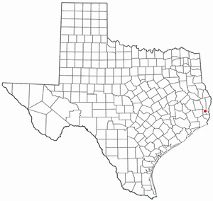
Buna is an unincorporated community and census-designated place (CDP) in Jasper County, Texas, United States. The population was 2,137 at the 2020 census.

Los Alvarez is a census-designated place (CDP) in Starr County, Texas, United States. The population was 303 at the 2010 census, a decline from the figure of 1,434 tabulated in 2000.

Lake Morton-Berrydale is a census-designated place (CDP) in King County, Washington, United States. The population was 10,474 at the 2020 census.

Roosevelt is an unincorporated community and census-designated place (CDP) in Klickitat County, Washington, United States. The population was 156 at the 2010 census, up from 79 at the 2000 census. The Roosevelt Regional Landfill, one of the largest landfills in the United States, is located at Roosevelt.

Daniels is a census-designated place (CDP) in Raleigh County, West Virginia, United States. The population was 1,881 at the 2010 census.

Lac du Flambeau is a census-designated place (CDP) in the town of Lac du Flambeau in Vilas County, Wisconsin, United States. The population was 1,845 at the 2020 census. Lac du Flambeau is the major community for the Lac du Flambeau Band of Lake Superior Chippewa tribe.
Bar Harbor is a census-designated place (CDP) in the town of Bar Harbor in Hancock County, Maine, United States. The CDP population was 2,552 at the 2010 census, out of a population of 5,235 in the town of Bar Harbor as a whole.


