Shoshone County | |
---|---|
Coordinates: 47°21′N115°53′W / 47.35°N 115.89°W | |
Country | United States |
State | Idaho |
Founded | February 4, 1864 |
Named for | Shoshone tribe |
Seat | Wallace |
Largest city | Kellogg |
Area | |
• Total | 2,635 sq mi (6,820 km2) |
• Land | 2,630 sq mi (6,800 km2) |
• Water | 5.5 sq mi (14 km2) 0.2% |
Population (2020) | |
• Total | 13,169 |
• Density | 5.0/sq mi (1.9/km2) |
Time zone | UTC−8 (Pacific) |
• Summer (DST) | UTC−7 (PDT) |
Congressional district | 1st |
Website | shoshonecounty |
Shoshone County (pronunciation: shuh-SHONE) is a county in the U.S. state of Idaho. As of the 2020 census, the population was 13,169. [1] The county seat is Wallace and the largest city is Kellogg. The county was established in 1864, named for the Native American Shoshone tribe.
Shoshone County is commonly referred to as the Silver Valley, due to its century-old mining history. The Silver Valley is famous nationwide for the vast amounts of silver, lead, and zinc mined from it.
This section needs additional citations for verification .(March 2009) |
Shoshone County was formed under the Territory of Washington on January 9, 1861. [2] The territorial legislature established the county in anticipation of the gold rush that occurred after the discovery of gold at Pierce in October 1860. Their location of the northern boundary at a line drawn due east from the mouth of the Clearwater River, unknowingly placed the emerging mining settlement at Pierce outside of the county's boundaries while residents of the new Mormon settlement at Franklin were unknowingly within the established boundaries. Regardless of the geographic reality, the county seat was at Pierce.
Growth at Pierce was so rapid that Shoshone County boasted the largest vote of any county within Washington Territory at the territorial election of July 8, 1861. In less than a year, Shoshone County contained additional settlements at Lewiston, Elk City, Newsome, and Florence. On December 20, 1861, Nez Perce and Idaho counties were created from most of the original territory of Shoshone County. On the following day, Shoshone's boundaries were shifted northward, containing most of present-day Clearwater County and a portion of present-day Shoshone County. [3] [4]
This new boundary alignment left the existing settlement at Pierce and the new settlement of Orofino as the county's only settlements. The county's population dwindled as prospectors abandoned Pierce for gold prospects at Elk City and Florence. Idaho Territory was created in 1863 and the first census of the territory in that year enumerated only 574 residents in Shoshone County. [5] The county boundaries were expanded to include the Silver Valley by the legislative assembly of Idaho Territory when it officially created Shoshone County on February 4, 1864. The expanded territory contained no population at the second census of Idaho Territory in 1864. All of the county's 276 residents were located at Pierce and Orofino. [6] In the 1870 national census, 65% of the population were Chinese.
Until 1904, Shoshone County included present-day Clearwater County to the south. That portion was annexed by Nez Perce County for several years and then was established as a new county in 1911. [7] When the Silver Valley population rose dramatically in the 1880s, the seat was moved to Murray in 1884 (and to Wallace in 1898) to better serve the majority of the county's population. The southern area's population increased with homesteading in the Weippe area in the late 1890s. The vast distance and time required for travel to Wallace from the Clearwater River area prompted the southern portion to move to Nez Perce County.
Hard rock miners in Shoshone County protested wage cuts with a strike in 1892. After several died in a shooting war provoked by discovery of a company spy, the U.S. Army forced an end to the strike. Hostilities erupted once again in 1899 when, in response to the company firing seventeen men for joining the union, the miners dynamited the Bunker Hill & Sullivan mill. Again, people died, and the U.S. Army intervened, requested by Governor Frank Steunenberg, as the Idaho National Guard troops were still stationed in the Philippines following the Spanish–American War. Steunenberg was assassinated outside his residence in Caldwell in 1905, nearly five years after leaving office, and the subsequent trials in Boise in 1907 made national headlines.
Much of the county was burned in the Great Fire of 1910, including parts of Wallace. [8]
According to the U.S. Census Bureau, the county has an area of 2,635 square miles (6,820 km2), of which 2,630 square miles (6,800 km2) is land and 5.5 square miles (14 km2) (0.2%) is water. [9]
Census | Pop. | Note | %± |
---|---|---|---|
1870 | 722 | — | |
1880 | 469 | −35.0% | |
1890 | 5,382 | 1,047.5% | |
1900 | 11,950 | 122.0% | |
1910 | 13,963 | 16.8% | |
1920 | 14,250 | 2.1% | |
1930 | 19,060 | 33.8% | |
1940 | 21,230 | 11.4% | |
1950 | 22,806 | 7.4% | |
1960 | 20,876 | −8.5% | |
1970 | 19,718 | −5.5% | |
1980 | 19,226 | −2.5% | |
1990 | 13,931 | −27.5% | |
2000 | 13,771 | −1.1% | |
2010 | 12,765 | −7.3% | |
2020 | 13,169 | 3.2% | |
2023 (est.) | 14,026 | [10] | 6.5% |
U.S. Decennial Census [11] 1790–1960 [12] 1900–1990 [13] 1990–2000 [14] 2010–2020 [15] 2020 [1] The county seat is Wallace, [16] |
As of the census [17] of 2000, there were 13,771 people, 5,906 households, and 3,856 families living in the county. The population density was 5 people per square mile (1.9 people/km2). There were 7,057 housing units at an average density of 3 units per square mile (1.2 units/km2). The racial makeup of the county was 95.84% White, 0.11% Black or African American, 1.52% Native American, 0.23% Asian, 0.07% Pacific Islander, 0.49% from other races, and 1.74% from two or more races. 1.93% of the population were Hispanic or Latino of any race. 22.1% were of German, 14.0% American, 11.3% English, 9.7% Irish and 5.9% Norwegian ancestry.
There were 5,906 households, out of which 26.70% had children under the age of 18 living with them, 52.70% were married couples living together, 8.10% had a female householder with no husband present, and 34.70% were non-families. 29.40% of all households were made up of individuals, and 13.60% had someone living alone who was 65 years of age or older. The average household size was 2.30 and the average family size was 2.82.
In the county, the population was spread out, with 22.90% under the age of 18, 6.70% from 18 to 24, 25.50% from 25 to 44, 27.40% from 45 to 64, and 17.40% who were 65 years of age or older. The median age was 42 years. For every 100 females there were 99.40 males. For every 100 females age 18 and over, there were 97.00 males.
The median income for a household in the county was $28,535, and the median income for a family was $35,694. Males had a median income of $30,439 versus $18,831 for females. The per capita income for the county was $15,934. About 12.40% of families and 16.40% of the population were below the poverty line, including 21.80% of those under age 18 and 10.00% of those age 65 or over.
As of the 2010 United States Census, there were 12,765 people, 5,605 households, and 3,511 families living in the county. [18] The population density was 4.9 inhabitants per square mile (1.9/km2). There were 7,061 housing units at an average density of 2.7 units per square mile (1.0 units/km2). [19] The racial makeup of the county was 95.4% white, 1.4% American Indian, 0.4% Asian, 0.2% black or African American, 0.1% Pacific islander, 0.5% from other races, and 2.0% from two or more races. Those of Hispanic or Latino origin made up 3.0% of the population. [18] In terms of ancestry, 32.2% were German, 17.6% were Irish, 13.5% were English, 6.4% were Norwegian, and 4.4% were American. [20]
Of the 5,605 households, 25.4% had children under the age of 18 living with them, 48.5% were married couples living together, 8.7% had a female householder with no husband present, 37.4% were non-families, and 31.3% of all households were made up of individuals. The average household size was 2.25 and the average family size was 2.79. The median age was 46.2 years. [18]
The median income for a household in the county was $36,654 and the median income for a family was $44,685. Males had a median income of $38,315 versus $25,273 for females. The per capita income for the county was $19,020. About 13.8% of families and 17.9% of the population were below the poverty line, including 22.5% of those under age 18 and 8.3% of those age 65 or over. [21]
Year | Republican | Democratic | Third party | |||
---|---|---|---|---|---|---|
No. | % | No. | % | No. | % | |
2020 | 4,216 | 69.70% | 1,693 | 27.99% | 140 | 2.31% |
2016 | 3,297 | 64.39% | 1,384 | 27.03% | 439 | 8.57% |
2012 | 2,699 | 52.43% | 2,277 | 44.23% | 172 | 3.34% |
2008 | 2,953 | 52.11% | 2,521 | 44.49% | 193 | 3.41% |
2004 | 2,922 | 54.75% | 2,331 | 43.68% | 84 | 1.57% |
2000 | 2,879 | 53.46% | 2,225 | 41.32% | 281 | 5.22% |
1996 | 1,588 | 26.67% | 2,981 | 50.07% | 1,385 | 23.26% |
1992 | 1,441 | 22.01% | 3,182 | 48.59% | 1,925 | 29.40% |
1988 | 2,134 | 38.20% | 3,379 | 60.49% | 73 | 1.31% |
1984 | 3,156 | 50.22% | 3,033 | 48.27% | 95 | 1.51% |
1980 | 3,994 | 52.04% | 3,102 | 40.42% | 579 | 7.54% |
1976 | 3,570 | 51.67% | 3,216 | 46.55% | 123 | 1.78% |
1972 | 3,868 | 53.67% | 3,020 | 41.90% | 319 | 4.43% |
1968 | 3,080 | 40.60% | 3,850 | 50.74% | 657 | 8.66% |
1964 | 2,884 | 35.70% | 5,194 | 64.30% | 0 | 0.00% |
1960 | 3,432 | 40.70% | 5,001 | 59.30% | 0 | 0.00% |
1956 | 4,598 | 50.83% | 4,448 | 49.17% | 0 | 0.00% |
1952 | 5,119 | 51.91% | 4,684 | 47.50% | 59 | 0.60% |
1948 | 3,200 | 38.74% | 4,472 | 54.13% | 589 | 7.13% |
1944 | 3,162 | 37.36% | 5,290 | 62.51% | 11 | 0.13% |
1940 | 3,525 | 34.65% | 6,565 | 64.54% | 82 | 0.81% |
1936 | 2,146 | 28.30% | 5,377 | 70.92% | 59 | 0.78% |
1932 | 2,902 | 39.49% | 4,347 | 59.15% | 100 | 1.36% |
1928 | 3,648 | 59.64% | 2,430 | 39.73% | 39 | 0.64% |
1924 | 3,034 | 51.02% | 835 | 14.04% | 2,078 | 34.94% |
1920 | 3,112 | 64.23% | 1,733 | 35.77% | 0 | 0.00% |
1916 | 2,431 | 33.90% | 4,239 | 59.11% | 501 | 6.99% |
1912 | 1,399 | 27.68% | 1,634 | 32.33% | 2,021 | 39.99% |
1908 | 3,256 | 55.07% | 2,109 | 35.67% | 547 | 9.25% |
1904 | 3,095 | 62.04% | 1,116 | 22.37% | 778 | 15.59% |
1900 | 2,378 | 44.27% | 2,994 | 55.73% | 0 | 0.00% |
Shoshone County was historically a Democratic-leaning county, but in recent years has voted for Republican presidential candidates, while favoring Democratic candidates locally and statewide. The county polled a majority for Democratic Gubernatorial candidate Jerry Brady and Democratic Senatorial candidate Larry LaRocco, but Barack Obama lost in 2008 by an eight-point margin.
School districts include: [23]
It is in the catchment area, but not the taxation zone, for North Idaho College. [24]
Lewiston is a city and the county seat of Nez Perce County, Idaho, United States, in the state's north central region. It is the third-largest city in the northern Idaho region, behind Post Falls and Coeur d'Alene, and the twelfth-largest in the state. Lewiston is the principal city of the Lewiston, ID-WA Metropolitan Statistical Area, which includes all of Nez Perce County and Asotin County, Washington. As of the 2020 census, the population of Lewiston was 34,203, up from 31,894 in 2010.
Nez Perce County is a county located in the U.S. state of Idaho. As of the 2020 census, the population was 42,090. The county seat is Lewiston. The county is named after the Native American Nez Perce tribe. Nez Perce County is part of the Lewiston, Idaho–WA Metropolitan Statistical Area.
Wallowa County is the northeastern most county in the U.S. state of Oregon. As of the 2020 census, the population was 7,391, making it Oregon's fifth-least populous county. Its county seat is Enterprise. According to Oregon Geographic Names, the origins of the county's name are uncertain, with the most likely explanation being it is derived from the Nez Perce term for a structure of stakes used in fishing. An alternative explanation is that Wallowa is derived from a Nez Perce word for "winding water". The journals of Lewis and Clark Expedition record the name of the Wallowa River as Wil-le-wah.
Beaverhead County is the largest county by area in the U.S. state of Montana. As of the 2020 census, the population was 9,371. Its county seat is Dillon. The county was founded in 1865.
Owyhee County is a county in the southwestern corner of the U.S. state of Idaho. As of the 2020 census, the population was 11,913. The county seat is Murphy, and its largest city is Homedale. In area it is the second-largest county in Idaho, behind Idaho County.
Lewis County is a county located in the north central region of the U.S. state of Idaho. As of the 2020 census, the population was 3,533, making it the fourth-least populous county in Idaho. The county seat is Nezperce, and Kamiah is the largest city. Partitioned from Nez Perce County and established in 1911, it was named after the explorer Meriwether Lewis. Most of the county is within the Nez Perce Indian Reservation, though Native Americans comprise less than 6% of the county population. Similar to the opening of lands in Oklahoma, the U.S. government opened the reservation for white settlement in November 1895. The proclamation had been signed less than two weeks earlier by President Cleveland.
Latah County is a county located in the north central region of the U.S. state of Idaho. As of the 2020 census, the population was 39,517. The county seat and largest city is Moscow, the home of the University of Idaho, the state's flagship university.
Kootenai County is located in the U.S. state of Idaho. As of the 2020 census, its population was 171,362, making it the third-most populous county in Idaho and by far the largest in North Idaho, the county accounting for 45.4% of the region's total population. The county seat and largest city is Coeur d'Alene. The county was established in 1864 and named after the Kootenai tribe.
Idaho County is a county in the U.S. state of Idaho, and the largest by area in the state. As of the 2020 census, the population was 16,541. The county seat is Grangeville. Previous county seats of the area were Florence (1864–68), Washington (1868–75), and Mount Idaho (1875–1902).
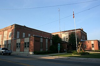
Clearwater County is a county located in the U.S. state of Idaho. As of the 2020 census, the population was 8,734. The county seat is Orofino. Established in 1911, the county was named after the Clearwater River.
Clark County is a rural county in the U.S. state of Idaho; its county seat and largest city is Dubois. As of the 2020 census, the population was 790, making it the least populous county in the state.
Bonner County is a county in the northern part of the U.S. state of Idaho. As of the 2020 census, the population was 47,110. The county seat and largest city is Sandpoint. Partitioned from Kootenai County and established in 1907, it was named for Edwin L. Bonner, a ferry operator.
Orofino is a city in and the county seat of Clearwater County, Idaho, United States, along Orofino Creek and the north bank of the Clearwater River. It is the major city within the Nez Perce Indian Reservation. The population was 3,142 at the time of the 2010 census.
Pierce is a city in the northwest United States, located in Clearwater County, Idaho. The population was 508 at the 2010 census, down from 617 in 2000.
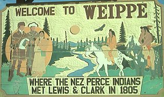
Weippe is a city in Clearwater County, Idaho, United States. The population was 441 at the 2010 census, up from 411 in 2000. In September 1805, the starving Lewis and Clark Expedition first met the Nez Perce on the Weippe Prairie, south of the city.
Kamiah is a city in Lewis and Idaho counties in the U.S. state of Idaho. The largest city in Lewis County, it extends only a small distance into Idaho County, south of Lawyer Creek. The population was 1,295 at the 2010 census, up from 1,160 in 2000. The city lies in the narrow valley of the Clearwater River; downstream are Orofino and Lewiston, at the confluence with the Snake River.
Kooskia is a city in Idaho County, Idaho, United States. It is at the confluence of the South and Middle forks of the Clearwater River, combining to become the main river. The population was 607 at the 2010 census, down from 675 in 2000.
Nezperce is a city in and the county seat of Lewis County, Idaho, United States. The population was 466 at the 2010 census, down from 523 in 2000. Nezperce is named for the local Nez Perce tribe of Native Americans. There is one school district, Nezperce School District #302.
Lapwai is a city in Nez Perce County, Idaho, United States. Its population was 1,137 at the 2010 census, and it is the seat of government of the Nez Perce Indian Reservation.
The Lewiston–Clarkston metropolitan area—colloquially referred to as the Lewiston–Clarkston Valley or Lewis–Clark Valley, and officially known as the Lewiston, ID–WA Metropolitan Statistical Area—is a metropolitan area comprising Nez Perce County, Idaho, and Asotin County, Washington. The metro is anchored by the cities of Lewiston, Idaho, and Clarkston, Washington—named after Meriwether Lewis and William Clark, respectively. As of the 2010 census, the MSA had a population of 60,888, making it the 4th smallest metropolitan area in the United States.