Shoshone County is a county in the U.S. state of Idaho. As of the 2020 census, the population was 13,169. The county seat is Wallace and the largest city is Kellogg. The county was established in 1864, named for the Native American Shoshone tribe.
Owyhee County is a county in the southwestern corner of the U.S. state of Idaho. As of the 2020 census, the population was 11,913. The county seat is Murphy, and its largest city is Homedale. In area it is the second-largest county in Idaho, behind Idaho County.
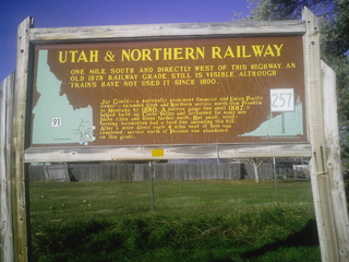
The Utah & Northern Railway is a defunct railroad that was operated in the Utah Territory and later in the Idaho Territory and Montana Territory in the western United States during the 1870s and 1880s. It was the first railroad in Idaho and in Montana. The line was acquired by a Union Pacific Railroad subsidiary, the Oregon Short Line, and is today operated by the Union Pacific Railroad as the Ogden Subdivision, part of the Pocatello Subdivision, and the Montana Subdivision.

Murphy is a census-designated place in, and the county seat of, Owyhee County, Idaho, United States. It is among the smallest of county seats nationwide, with a population as of the 2020 census of 96. Murphy is part of the Boise City–Nampa, Idaho Metropolitan Statistical Area. Murphy is also located within the census-designated place bearing its name. Murphy is home to the Owyhee County Historical Museum and Library.

Burke is a ghost town in Shoshone County, Idaho, United States, established in 1887. Once a thriving silver, lead and zinc mining community, the town saw significant decline in the mid-twentieth century after the closure of several mines.
The Silver Valley is a region in the northwest United States, in the Coeur d'Alene Mountains in northern Idaho. It is noted for its mining heritage, dating back to the 1880s.

Atlanta is an unincorporated community in the western United States, located in Elmore County, Idaho.

Burke Canyon is the canyon of the Burke-Canyon Creek, which runs through the northernmost part of Shoshone County, Idaho, U.S., within the northeastern Silver Valley. A hotbed for mining in the late-nineteenth and twentieth centuries, Burke Canyon now contains several ghost towns and remnants of former communities along Idaho State Highway 4, which runs northeast through the narrow canyon to the Montana border.
Fish Haven, originally named Rush Creek, is an unincorporated community along the shores of Bear Lake in Bear Lake County, Idaho, United States. It is 4 km north of the Utah border.

Cataldo is an unincorporated community in Kootenai and Shoshone counties in northern Idaho. It is located at an altitude of 2,139 feet (652 m). Cataldo lies on the southeast banks of the Coeur d'Alene River and Interstate 90 passes the south side of the community. The community of Kingston lies along I-90 to the east. The ZIP Code for Cataldo is 83810.

Leesburg is an unincorporated community in Lemhi County, Idaho, United States. It lies at 45°13′26″N114°6′50″W, along Napias Creek in the Salmon National Forest, west of Salmon. Its altitude is 6,653 feet (2,028 m).
Dixie is an unincorporated community in Idaho County, Idaho, United States, located 43 miles (69 km) east-northeast of Riggins. Dixie was an important gateway to the Thunder Mountain Mines of Idaho during the early 1900s when Dixie was on the northern terminus of the Three Blaze Trail, a shortcut route to the mines via Campbell's Ferry, and what is now the Frank Church-River of No Return Wilderness, Chamberlain Basin, and southward to the mining community of Roosevelt, located on Monumental Creek.
Calder is an unincorporated community in Shoshone County, Idaho, United States. Calder is located on the Saint Joe River 18 miles (29 km) east of St. Maries. Calder has a post office with ZIP code 83808.
Laclede is an unincorporated community in Bonner County, Idaho, United States. Laclede is located on U.S. Route 2 at the intersection of Riley Creek and the Pend Oreille River. Laclede has a post office with ZIP code 83841.
Kingston is an unincorporated community in Shoshone County, Idaho, United States. Kingston is located on the south bank of the Coeur d'Alene River along Interstate 90 about 2 miles (3.2 km) northwest of Pinehurst.

Harvard is an unincorporated community in the northwest United States, on the Palouse of north central Idaho in Latah County.
Lane is an unincorporated community in Kootenai County, Idaho, United States. Lane is located along the Coeur d'Alene River and Idaho State Highway 3. It is 12 miles (19 km) northeast of Harrison. The community was founded as a lumber town in the 1880s and named after a logger.
Mink Creek is an unincorporated community in Franklin County, Idaho, United States. Mink Creek is located along Idaho State Highway 36 12.5 miles (20.1 km) northeast of Preston.
Avon is an unincorporated community in Latah County, in the U.S. state of Idaho.

Helmer is an unincorporated community in Latah County, Idaho, United States.


