S.N.P.J. is a borough in western Lawrence County, Pennsylvania, United States. As of the 2020 Census, the borough had a population of 15. It is part of the Pittsburgh metropolitan area.

North Central Idaho is an area which spans the central part of the state of Idaho and borders Oregon, Montana, and Washington. It is the southern half of the state's Panhandle region and is rich in agriculture and natural resources. Lewis and Clark traveled through this area on their journey to the Pacific Ocean in September 1805, crossing Lolo Pass and continuing westward in canoes on the Clearwater River. They returned the following spring on their way eastward.

Rocky Bar is a ghost town in Elmore County, Idaho, United States. At its height in the late 19th century Rocky Bar boasted a population of over 2,500 and served as county seat of Alturas County from 1864 to 1882. It was also the original county seat of Elmore County when it was created in 1889.

The Great Fire of 1910 was a wildfire in the Inland Northwest region of the United States that in the summer of 1910 burned three million acres in North Idaho and Western Montana, with extensions into Eastern Washington and Southeast British Columbia. The area burned included large parts of the Bitterroot, Cabinet, Clearwater, Coeur d'Alene, Flathead, Kaniksu, Kootenai, Lewis and Clark, Lolo, and St. Joe national forests. The fire burned over two days on the weekend of August 20–21, after strong winds caused numerous smaller fires to combine into a firestorm of unprecedented size. It killed 87 people, mostly firefighters, destroyed numerous manmade structures, including several entire towns, and burned more than three million acres of forest with an estimated billion dollars' worth of timber lost. While the exact cause of the fire is often debated, according to various U.S. Forest Service sources, the primary cause of the Big Burn was a combination of severe drought and a series of lightning storms that ignited hundreds of small fires across the Northern Rockies. However, the ignition sources also include human activity such as railroads, homesteaders, and loggers. It is believed to be the largest, although not the deadliest, forest fire in U.S. history.
Limestone Run is a 4.6-mile-long (7.4 km) stream that lies to the east of New Creek Mountain in Mineral County, West Virginia. It is a tributary of the North Branch Potomac River.

Rugged Point Marine Provincial Park is a provincial park in British Columbia, Canada, located at the southeast entrance to Kyuquot Sound on the west coast of Vancouver Island. It is remote and largely visited by kayakers.
Garden Valley is an unincorporated census-designated place in Boise County, Idaho, United States. As of the 2010 census, its population was 394. The mountain setting and recreation opportunities attract visitors from the Boise area. Life there during the pioneer days was quite harsh and economic opportunity was based on logging, mining, and ranching. In later years there was work as hunting guides.

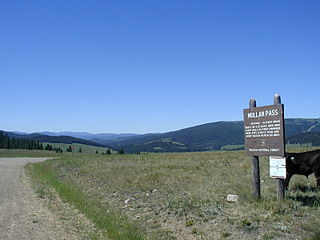
Mullan Pass is a mountain pass in the western United States, in the Rocky Mountains of Montana. It sits on the Continental Divide on the border between Powell and Lewis and Clark counties at 5,902 feet (1,799 m) above sea level. Located in the Helena National Forest, the pass is thirteen miles (20 km) west of the city of Helena.
Minnesota's 8th congressional district covers the northeastern part of Minnesota. It is anchored by Duluth, the state's fifth-largest city. It also includes most of the Mesabi & Vermilion iron ranges, and the Boundary Waters Canoe Area in the Superior National Forest. The district is best known for its mining, agriculture, tourism, and shipping industries.
Lookout Pass is a mountain pass in the Rocky Mountains of the northwestern United States. In the Coeur d'Alene Mountains of the Bitterroot Range, the pass is on the border between Idaho and Montana, traversed by Interstate 90 at an elevation of 4,710 feet (1,436 m) above sea level.

Burke Canyon is the canyon of the Burke-Canyon Creek, which runs through the northernmost part of Shoshone County, Idaho, U.S., within the northeastern Silver Valley. A hotbed for mining in the late-nineteenth and twentieth centuries, Burke Canyon now contains several ghost towns and remnants of former communities along Idaho State Highway 4, which runs northeast through the narrow canyon to the Montana border.
The Paint River is a 45.5-mile-long (73.2 km) river in the U.S. state of Michigan.

The Clearwater River is in the northwestern United States, in north central Idaho. Its length is 74.8 miles (120.4 km), it flows westward from the Bitterroot Mountains along the Idaho-Montana border, and joins the Snake River at Lewiston. In October 1805, the Lewis and Clark Expedition descended the Clearwater River in dugout canoes, putting in at "Canoe Camp," five miles (8 km) downstream from Orofino; they reached the Columbia Bar and the Pacific Ocean about six weeks later.

Yukon High School is a secondary school located within Canadian County in Yukon, Oklahoma.

Castelo de Longroiva is a castle in Portugal. It is classified as a National Monument.
Big Dick Point is a summit in Shoshone County, Idaho, in the United States. With an elevation of 5,414 feet (1,650 m), Big Dick Point is the 1,822nd tallest mountain in Idaho. It is located to the south of Big Dick Creek.
Prichard is an unincorporated community in Shoshone County, Idaho, United States.
Garfield is an unincorporated community in Bonneville and Jefferson counties, in the U.S. state of Idaho.


