Avery, Idaho

Last updated

Avery, Idaho
Averyfallnew.jpg
Avery and St. Joe River in the fall
USA Idaho relief location map.svg
Red pog.svg
Avery
Usa edcp relief location map.png
Red pog.svg
Avery
Coordinates: 47°15′00″N115°48′07″W / 47.25°N 115.802°W / 47.25; -115.802
Country United States
State Idaho
County Shoshone
Elevation
[1]
2,486 ft (758 m)
Population
 (2000)
  Total25
Time zone UTC-8 (Pacific Time Zone)
  Summer (DST) UTC-7
ZIP code
83802 [2]
Area code 208
Hotel Idaho in Avery (1915) Avery, Idaho. Hotel Idaho - NARA - 298402.tif
Hotel Idaho in Avery (1915)

Avery is a small unincorporated community in the northwest United States, located in the St. Joe River Valley in Shoshone County, Idaho. Avery is located in the middle of the St. Joe District of the Idaho Panhandle National Forest, and is a tourist attraction in the Idaho Panhandle known for its wilderness and outdoor recreation.[ citation needed ] It is upstream and east of St. Maries, the county seat of Benewah County.

Contents

Geography

Avery is located at a latitude of 47.25 ºN, longitude 115.81 ºW, and an elevation of 2562 ft (781m) above sea level. [3]

Climate

This climatic region is typified by large seasonal temperature differences, with warm to hot (and often humid) summers and cold (sometimes severely cold) winters. According to the Köppen Climate Classification system, Avery has a humid continental climate, abbreviated "Dfb" on climate maps. [4]

Demographics

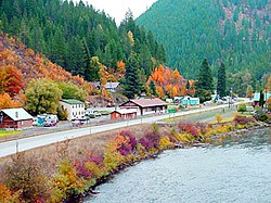
As of 2013, Avery had a population of 25 permanent residents. [5] The temporary population is higher in the summer though due to seasonal workers for the United States Forest Service and the many summer homes in Avery and along the St. Joe River.[ citation needed ]. The small population is served by the Avery School District, also serving Calder, Idaho and Clarkia, Idaho. [6]

History

The town was from the years 1909 to 1980 a division point on the Pacific Extension of the Chicago, Milwaukee, St. Paul and Pacific Railroad ("Milwaukee Road"). It was also once the western terminus for the easternmost of two electrified mountain sections on the route; the other ran in Washington from Othello, through the Cascade Range to the Puget Sound. Electric operations ran from 1914–74 on this section east to Harlowton, Montana. Trains stopped at the Avery Depot, now listed on the National Register of Historic Places. Here, steam or diesel locomotives were changed or hooked up to electric locomotives.[ citation needed ]

During the Great Fire of 1910, a 28-man firefighting team died near Setzer Creek outside of Avery. [7] The U.S. Army's 25th Infantry Regiment (known as the Buffalo Soldiers) helped build a back fire that saved Avery. [8] During the fire, many found refuge in the newly-constructed railroad tunnels between Avery and the St. Paul Pass Tunnel (a.k.a. Taft Tunnel) to the northeast.

Avery's population was 450 in 1960. [9]

With ongoing financial problems which worsened in the 1970s, the Milwaukee Road abandoned its right-of-way in the West in 1980, but the tunnels and grades east of Avery are now a rail trail route for hikers and bicyclists, the Route of the Hiawatha Trail. [10]

Recreation

Common activities include nature photography, camping, hunting, ATV riding, snowmobiling, hiking, horseback riding, mountain biking, fishing, and rafting.[ citation needed ]

Attractions

The main attraction in Avery is the Fish Pond. All year long, tourists can purchase a handful of fish food for twenty-five cents and watch as the massive rainbow trout leap out of the water to get a bite to eat. [11] [ tone ]

Related Research Articles

<span class="mw-page-title-main">Wallace, Idaho</span> City in Idaho, United States

Wallace, Idaho is a city in and the county seat of Shoshone County, Idaho, in the Silver Valley mining district of the Idaho Panhandle. Founded in 1884, Wallace sits alongside the South Fork of the Coeur d'Alene River. The town's population was 784 at the 2010 census.

<span class="mw-page-title-main">Harlowton, Montana</span> City in and county seat of Wheatland County, Montana, United States

Harlowton is a city in and the county seat of Wheatland County, Montana, United States. The population was 955 at the 2020 census.

<span class="mw-page-title-main">Continental Divide Trail</span> Long-distance scenic trail in the western United States

The Continental Divide National Scenic Trail is a United States National Scenic Trail with a length measured by the Continental Divide Trail Coalition of 3,028 miles (4,873 km) between the U.S. border with Chihuahua, Mexico and the border with Alberta, Canada. Frequent route changes and a large number of alternate routes result in an actual hiking distance of 2,700 miles (4,300 km) to 3,150 miles (5,070 km). The CDT follows the Continental Divide of the Americas along the Rocky Mountains and traverses five U.S. states — Montana, Idaho, Wyoming, Colorado, and New Mexico. In Montana near the Canadian border the trail crosses Triple Divide Pass.

<span class="mw-page-title-main">Milwaukee Road</span> Class I railroad that operated in the Midwest and Northwest of the United States

The Chicago, Milwaukee, St. Paul and Pacific Railroad (CMStP&P), better known as "Milwaukee Road", was a Class I railroad that operated in the Midwest and Northwest of the United States from 1847 until 1986.

<i>Empire Builder</i> Northern U.S. rail service

The Empire Builder is a daily long-distance passenger train operated by Amtrak between Chicago and either Seattle or Portland via two sections west of Spokane. Introduced in 1929, it was the flagship passenger train of the Great Northern Railway and was retained by Amtrak when it took over intercity rail service in 1971.

Taft is a populated place in Mineral County, Montana. Located in the Bitterroot Range near the Idaho border along the route of the Mullan Road, it was a thriving railroad town c. 1908, named after William H. Taft.

<span class="mw-page-title-main">Great Fire of 1910</span> 1910 wildfire in the northwestern United States

The Great Fire of 1910 was a wildfire in the Inland Northwest region of the United States that burned three million acres in North Idaho and Western Montana, with extensions into Eastern Washington and Southeast British Columbia, in the summer of 1910. The area burned included large parts of the Bitterroot, Cabinet, Clearwater, Coeur d'Alene, Flathead, Kaniksu, Kootenai, Lewis and Clark, Lolo, and St. Joe national forests.

<span class="mw-page-title-main">Idaho Panhandle National Forests</span> National forests in Idaho, United States

The Idaho Panhandle National Forests are a jointly administered set of three national forests located mostly in the U.S. state of Idaho. In 1973, major portions of the Kaniksu, Coeur d'Alene, and St. Joe National Forests were combined to be administratively managed as the Idaho Panhandle National Forests (IPNF). The IPNF consists of more than 2.5 million acres (10,000 km2) of public lands in the panhandle of north Idaho, with small areas extending into eastern Washington (4.7%) and western Montana (1.2%). The northernmost portion of the IPNF share a boundary with Canada. The Forest Supervisor's office is located in Coeur d'Alene, Idaho with district office's in Bonners Ferry, Sandpoint, Priest River, Fernan and Smelterville, and St. Maries and Avery.

<i>Olympian Hiawatha</i> 1911–1961 passenger train from Chicago to the Pacific Northwest

The Olympian and its successor the Olympian Hiawatha were passenger trains operated by the Chicago, Milwaukee, St. Paul and Pacific Railroad between Chicago and the Pacific Northwest. The Olympian operated from 1911 to 1947 and was, along with its running mate the Columbian, the first all-steel train to operate in the Pacific Northwest. The streamlined Olympian Hiawatha operated from 1947 to 1961 and was one of several Milwaukee Road trains to carry the name "Hiawatha." The Olympian Hiawatha was designed by industrial designer Brooks Stevens and included the distinctive glassed-in "Skytop" observation-sleeping cars. It later featured full-length "Super Dome" cars.

<span class="mw-page-title-main">Clarkia, Idaho</span> Unincorporated community in the state of Idaho, United States

Clarkia is a small unincorporated community in the southwestern corner of Shoshone County, Idaho. It is surrounded by publicly and privately managed forest lands of Douglas-fir, Ponderosa Pine, and Western Larch. Located just to the east of State Highway 3, the town is in the drainage area of the West Fork of the St. Maries River.

The Silver Valley is a region in the northwest United States, in the Coeur d'Alene Mountains in northern Idaho. It is noted for its mining heritage, dating back to the 1880s.

Lookout Pass is a mountain pass in the Rocky Mountains of the northwestern United States. In the Coeur d'Alene Mountains of the Bitterroot Range, the pass is on the border between Idaho and Montana, traversed by Interstate 90 at an elevation of 4,710 feet (1,436 m) above sea level.

Lookout Pass Ski and Recreation Area is a ski area in the western United States. It is at Lookout Pass on Interstate 90, on the border of Idaho and Montana, five miles (8 km) east of Mullan, Idaho. It has a summit elevation of 6,150 ft (1,870 m) on Eagle Peak and 5,650 ft (1,720 m) on Runt Mountain with a vertical drop of 1,650 ft (500 m). Lookout Pass operates seven days per week from mid-December until mid-April.

<span class="mw-page-title-main">Palouse to Cascades State Park Trail</span>

The Palouse to Cascades State Park Trail, formerly known as the John Wayne Pioneer Trail and the Iron Horse Trail, is a rail trail that spans most of the U.S. state of Washington. It follows the former railway roadbed of the Chicago, Milwaukee, St. Paul & Pacific Railroad for 300 miles (480 km) across two-thirds of the state, from the western slopes of the Cascade Mountains to the Idaho border.

Babb is a small unincorporated farming and ranching community in Glacier County, Montana, United States, on the Blackfeet Indian Reservation. The community experiences a large influx of tourists in the summer months as it is the gateway to the Many Glacier area of Glacier National Park. For statistical purposes, the United States Census Bureau has defined Babb as a census-designated place (CDP). It had a population of 174 at the 2010 census.

<span class="mw-page-title-main">Chicago, Milwaukee, St. Paul and Pacific Railroad Company Historic District</span> Historic district in Idaho, United States

The Chicago, Milwaukee, St. Paul and Pacific Railroad Company Historic District consists of the historic right-of-way of the Chicago, Milwaukee, St. Paul and Pacific Railroad in the Bitterroot Mountains from East Portal, Montana, to the mouth of Loop Creek, Idaho, a distance of 14.5 miles (23.3 km). The district was once part of the railroad's mainline from Chicago, Illinois to Tacoma, Washington.

<span class="mw-page-title-main">Edward Pulaski Tunnel and Placer Creek Escape Route</span> United States historic place

The Edward Pulaski Tunnel and Placer Creek Escape Route are two adjacent sites used by the United States Forest Service firefighter Edward Pulaski in the Great Fire of 1910 to save the lives of himself and most of his crew. The sites are located south of Wallace, Idaho in the Idaho Panhandle National Forests. Pulaski's tunnel and escape route are listed on the National Register of Historic Places in 1984.

<span class="mw-page-title-main">Sula, Montana</span> Census-designated place in Montana, United States

Sula is a census-designated place (CDP) in Ravalli County, Montana, United States. It is named after the village of Sula, which it encompasses, and was established about 2010, prior to that year's census. The population of the CDP was 37 at the 2010 census.

<span class="mw-page-title-main">Transportation in Montana</span>

Transportation in Montana comprises many different forms of travel. Montana shares a long border with Canada, hence international crossings are prevalent in the northern section of the state; there are 13 road crossings and one rail crossing.

The St. Paul Pass Tunnel was a railway tunnel in the northwest United States at St. Paul Pass, on the Montana-Idaho border. The tunnel was on the main line of the Chicago, Milwaukee, St. Paul & Pacific Railroad, commonly known as "The Milwaukee Road."

References

  1. U.S. Geological Survey Geographic Names Information System: USGS Place names
  2. "Avery ZIP Code". zipdatamaps.com. 2022. Retrieved November 11, 2022.
  3. "Map Avery - Idaho Longitude, Altitude - Sunset". www.usclimatedata.com. Retrieved October 26, 2020.
  4. Climate Summary for Avery, Idaho
  5. Robinson, Jessica (September 9, 2013). "Avery, Idaho Struggles To Keep Its Remaining 25 Residents And Its Spot On The Map". Boise State Public Radio. Retrieved February 17, 2014.
  6. "Avery School District". Avery School District 394. Retrieved March 21, 2022.
  7. Pyne, Stephen J. (2008). Year of the Fires: The Story of the Great Fires of 1910. Missoula, Montana: Mountain Press Publishing Company. pp. 155–157, 175–176. ISBN   978-0-87842-544-0.
  8. "The Big Burn-Transcript". American Experience. PBS. February 3, 2015. Retrieved January 23, 2019.
  9. World Book Encyclopedia. Vol. I. Field Enterprises Corporation. 1960. p. 27.
  10. "Trail map". Route of the Hiawatha. Retrieved January 31, 2018.
  11. Kaminsky, Stephen (May 20, 2003). "Get hooked in Avery". The Argonaut. University of Idaho. Archived from the original on February 14, 2006. Retrieved February 17, 2014.