Pinehurst, Idaho

Last updated
Pinehurst, Idaho
Shoshone County Idaho Incorporated and Unincorporated areas Pinehurst Highlighted 1663100.svg
Location of Pinehurst in Shoshone County, Idaho.
Coordinates: 47°32′14″N116°14′14″W / 47.53722°N 116.23722°W / 47.53722; -116.23722 Coordinates: 47°32′14″N116°14′14″W / 47.53722°N 116.23722°W / 47.53722; -116.23722
Country United States
State Idaho
County Shoshone
Government
  MayorRuss Lowe
Area
[1]
  Total1.00 sq mi (2.58 km2)
  Land1.00 sq mi (2.58 km2)
  Water0.00 sq mi (0.00 km2)
Elevation
2,224 ft (678 m)
Population
 (2010) [2]
  Total1,619
  Estimate 
(2019) [3]
1,626
  Density1,632.53/sq mi (630.40/km2)
Time zone UTC-8 (Pacific (PST))
  Summer (DST) UTC-7 (PDT)
ZIP code
83850
Area code(s) 208, 986
FIPS code 16-63100
GNIS feature ID0397038

Pinehurst is a city in Shoshone County, Idaho, United States. Located at the west end of the Silver Valley mining region, its population was 1,619 at the 2010 census.

Contents

Geography

Pine Creek Baptist Church, Pinehurst Pine Creek Baptist Church, Pinehurst, ID.jpg
Pine Creek Baptist Church, Pinehurst

Pinehurst is located at 47°32′14″N116°14′14″W / 47.53722°N 116.23722°W / 47.53722; -116.23722 (47.537193, -116.237085). [4] at an elevation of 2,224 feet (678 m) above sea level.

According to the United States Census Bureau, the city has a total area of 1.05 square miles (2.72 km2), all of it land. [5]

Demographics

Historical population
CensusPop.
1960 1,432
1970 1,93435.1%
1980 2,18312.9%
1990 1,722−21.1%
2000 1,661−3.5%
2010 1,619−2.5%
2019 (est.)1,626 [3] 0.4%
U.S. Decennial Census [6]

2010 census

As of the census [2] of 2010, there were 1,619 people, 721 households, and 458 families living in the city. The population density was 1,541.9 inhabitants per square mile (595.3/km2). There were 810 housing units at an average density of 771.4 per square mile (297.8/km2). The racial makeup of the city was 96.4% White, 0.1% African American, 1.0% Native American, 0.8% Asian, 0.2% from other races, and 1.5% from two or more races. Hispanic or Latino of any race were 3.5% of the population.

There were 721 households, of which 26.5% had children under the age of 18 living with them, 51.0% were married couples living together, 7.8% had a female householder with no husband present, 4.7% had a male householder with no wife present, and 36.5% were non-families. 31.9% of all households were made up of individuals, and 19.1% had someone living alone who was 65 years of age or older. The average household size was 2.25 and the average family size was 2.81.

The median age in the city was 45.8 years. 21.8% of residents were under the age of 18; 6.6% were between the ages of 18 and 24; 20.5% were from 25 to 44; 27.4% were from 45 to 64; and 23.7% were 65 years of age or older. The gender makeup of the city was 48.0% male and 52.0% female.

2000 census

As of the census [7] of 2000, there were 1,661 people, 720 households, and 495 families living in the city. The population density was 1,543.6 inhabitants per square mile (596.0/km2). There were 773 housing units at an average density of 718.4 per square mile (277.4/km2). The racial makeup of the city was 96.63% White, 1.38% Native American, 0.24% Asian, 0.06% Pacific Islander, 0.42% from other races, and 1.26% from two or more races. Hispanic or Latino of any race were 1.87% of the population.

There were 720 households, out of which 27.4% had children under the age of 18 living with them, 55.7% were married couples living together, 8.9% had a female householder with no husband present, and 31.3% were non-families. 28.1% of all households were made up of individuals, and 15.6% had someone living alone who was 65 years of age or older. The average household size was 2.31 and the average family size was 2.80.

In the city, the population was spread out, with 23.1% under the age of 18, 6.9% from 18 to 24, 25.1% from 25 to 44, 25.6% from 45 to 64, and 19.3% who were 65 years of age or older. The median age was 42 years. For every 100 females, there were 89.2 males. For every 100 females age 18 and over, there were 89.9 males.

The median income for a household in the city was $27,757, and the median income for a family was $34,185. Males had a median income of $31,932 versus $20,000 for females. The per capita income for the city was $15,268. About 13.5% of families and 14.8% of the population were below the poverty line, including 22.3% of those under age 18 and 9.4% of those age 65 or over.

Related Research Articles

<span class="mw-page-title-main">Deer Park, California</span> Census-designated place in California, United States

Deer Park is a census-designated place (CDP) in Napa County, California, United States. The population was 1,267 at the 2010 census. It is part of the Napa, California Metropolitan Statistical Area. Its area code is 707. Its zip code is 94576. It is in the Pacific time zone. Deer Creek is where Elmshaven, a large Victorian home lived in by Ellen White in the early twentieth century, is located.

<span class="mw-page-title-main">Granite Hills, California</span> Census-designated place in California, United States

Granite Hills is a census-designated place in San Diego County, California. The name is also applied to a neighborhood within the city limits of El Cajon in the eastern part of that city. The population of the CDP, which does not include the people living within the city of El Cajon, was 3,035 at the 2010 census, down from 3,246 at the 2000 census.

<span class="mw-page-title-main">Union Park, Florida</span> Census-designated place in Florida, United States

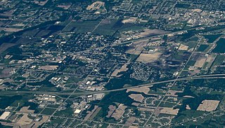
Union Park is a census-designated place (CDP) in Orange County, Florida, United States. The population was 10,452 at the 2020 census. It is part of the Orlando–Kissimmee Metropolitan Statistical Area. The ZIP codes for Union Park are 32817 and 32825. The community is southwest of the University of Central Florida.

<span class="mw-page-title-main">Dover, Idaho</span> City in Idaho, United States

Dover is a city in Bonner County, Idaho. The population was 556 at the 2010 census.

<span class="mw-page-title-main">East Hope, Idaho</span> City in Idaho, United States

East Hope is a city in Bonner County, Idaho, United States. The population was 210 at the 2010 census.

<span class="mw-page-title-main">Ponderay, Idaho</span> City in Idaho, United States

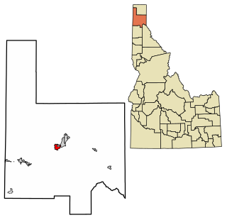
Ponderay is a city in Bonner County, Idaho. The population was 1,137 at the 2010 census, up from 638 in 2000. Ponderay's city motto is "Little City with the Big Future". Its name is an English phonetic spelling of the French words “Pend Oreille”, the name of the lake the city sits upon.

<span class="mw-page-title-main">Priest River, Idaho</span> City in Idaho, United States

Priest River is a city in Bonner County, Idaho. The population was 1,751 at the 2010 census. Located in the Idaho Panhandle region of the state, the city is at the mouth of the Priest River on the Pend Oreille River.

<span class="mw-page-title-main">Moyie Springs, Idaho</span> City in Idaho, United States

Moyie Springs is a city in Boundary County, Idaho, United States. The population was 718 at the 2010 census.

<span class="mw-page-title-main">Wilder, Idaho</span> City in Idaho, United States

Wilder is a city in Canyon County, Idaho, United States. The population was 1,533 at the 2010 census.

<span class="mw-page-title-main">Spirit Lake, Idaho</span> City in Idaho, United States

Spirit Lake is a city in Kootenai County, Idaho. The population was 1,945 at the time of the 2010 census, up from 1,376 in 2000. It is part of the Coeur d'Alene Metropolitan Statistical Area, which includes the entire county.

<span class="mw-page-title-main">Cambridge, Idaho</span> City in Idaho, United States

Cambridge is a city in Washington County, Idaho, United States. The population was 328 at the 2010 census, down from 360 in 2000. It is the second largest city in the county, behind the significantly larger Weiser, the county seat.

<span class="mw-page-title-main">Saratoga, Indiana</span> Town in Indiana, United States

Saratoga is a town in Ward Township, Randolph County, in the U.S. state of Indiana. The population was 254 at the 2010 census.

<span class="mw-page-title-main">Oyens, Iowa</span> City in Plymouth County, Iowa, United States

Oyens is a city in Plymouth County, Iowa, United States. The population was 92 at the time of the 2020 census.

<span class="mw-page-title-main">Montour, Iowa</span> City in Iowa, United States

Montour is a city in Tama County, Iowa, United States. The population was 203 at the time of the 2020 census.

<span class="mw-page-title-main">Hudsonville, Michigan</span> City in Michigan, United States

Hudsonville is a city in Ottawa County in the U.S. state of Michigan, and is part of the Grand Rapids metropolitan area. The population was 7,116 at the 2010 census. Hudsonville is nicknamed "Michigan's Salad Bowl."

<span class="mw-page-title-main">Florence, Minnesota</span> City in Minnesota, United States

Florence is a city in Lyon County, Minnesota, United States. The population was 39 at the 2010 census.

<span class="mw-page-title-main">Bassett, Nebraska</span> City in Nebraska, United States

Bassett is a city in Rock County, Nebraska, United States. The population was 619 at the 2010 census. It is the county seat of Rock County.

<span class="mw-page-title-main">Winnebago, Nebraska</span> Village in Nebraska, United States

Winnebago is a village in Thurston County, Nebraska, United States. The population was 916 at the 2020 census.

<span class="mw-page-title-main">Hartford, South Dakota</span> City in South Dakota, United States

Hartford is a suburban American city in Minnehaha County, South Dakota, a few miles northwest of Sioux Falls. Its population was 3,354 at the 2020 census.

Fort Devens is a census-designated place (CDP) in the towns of Ayer and Shirley, in Middlesex County and Harvard in Worcester County in the U.S. state of Massachusetts. It encompasses the former Fort Devens. The population was 1,017 at the 2000 census.

References

  1. "2019 U.S. Gazetteer Files". United States Census Bureau. Retrieved July 9, 2020.
  2. 1 2 "U.S. Census website". United States Census Bureau . Retrieved 2012-12-18.
  3. 1 2 "Population and Housing Unit Estimates". United States Census Bureau. May 24, 2020. Retrieved May 27, 2020.
  4. "US Gazetteer files: 2010, 2000, and 1990". United States Census Bureau. 2011-02-12. Retrieved 2011-04-23.
  5. "US Gazetteer files 2010". United States Census Bureau. Archived from the original on January 12, 2012. Retrieved 2012-12-18.
  6. "Census of Population and Housing". Census.gov. Retrieved June 4, 2015.
  7. "U.S. Census website". United States Census Bureau . Retrieved 2008-01-31.