This list refers only to the population of individual municipalities within their defined limits; the populations of other municipalities considered suburbs of a central city are listed separately, and unincorporated areas within urban agglomerations are not included. Therefore, a different ranking is evident when considering U.S. urban areas or metropolitan areas.
The total 2020 enumerated population of all incorporated municipalities over 100,000 is 96,598,047, representing 29.14% of the United States population (excluding territories) and covering a total land area of 29,588 square miles (76,630km2). The mean municipality population is 301,765, and the mean density is 4,151 inhabitants per square mile (1,603/km2).
The following table lists the five municipalities (municipios) of Puerto Rico with a population greater than 100,000 on July 1, 2024, as estimated by the United States Census Bureau. If Puerto Rican cities were included among the broader U.S. list, San Juan would rank as the 58th largest city in the country.[citation needed]
The table below contains the following information:
The municipality rank by population as of July 1, 2024, as estimated by the United States Census Bureau
The following table lists U.S. census-designated places (CDPs) with populations of at least 100,000 according to the 2020 census. A CDP is a concentration of population identified by the United States Census Bureau for statistical purposes. CDPs are delineated for each decennial census as the statistical counterparts of incorporated places such as cities, towns and villages. CDPs are populated areas that lack separate municipal government, but which otherwise physically resemble incorporated places. Unlike the incorporated cities in the main list, the US Census Bureau does not release annual population estimates for CDPs.
The table below contains the following information:
The following table lists U.S. cities that, in past censuses, have had populations of at least 100,000 but have since decreased beneath this threshold or have been consolidated with or annexed into a neighboring city.[1]
↑The State of Hawaiʻi has no incorporated municipalities other than the City and County of Honolulu, which comprises the entire Island of Oʻahu. In accordance with Hawaiian law, the United States Census Bureau defines the state's cities and towns as Census Designated Places (CDPs). The Census Bureau defines the Urban Honolulu CDP as the portion of the City and County of Honolulu that is coextensive with the Judicial District of Honolulu. The Urban Honolulu CDP is what is generally thought of as the "city" of Honolulu, and its population is used here and in other population comparisons. The Urban Honolulu CDP is currently the most populous Census Designated Place in the United States. The Honolulu, HI Metropolitan Statistical Area comprises the entire City and County of Honolulu.
↑The City of Honolulu, Hawaii, and Honolulu County, Hawaii, are separate entities with a single consolidated city–county government. The City of Honolulu (referred to as Urban Honolulu CDP by the US Census Bureau) comprises all of Honolulu County except the other unincorporated census-designated places within the county.
↑The City of Augusta, Georgia, and Richmond County, Georgia, are separate entities with a single consolidated city–county government. The City of Augusta comprises all of Richmond County except the two other incorporated municipalities within the county.
↑After approval by local voters in a 2012 referendum, the City of Macon, Georgia merged with most of unincorporated Bibb County, Georgia on January 1, 2014. The new consolidated government is officially "Macon-Bibb County".
↑Kansas City, Kansas, and Wyandotte County, Kansas, are separate entities with a single consolidated city–county government. Kansas City comprises all of Wyandotte County except the other incorporated municipalities within the county.
123Incorporated as a township. In New Jersey, townships are considered full-fledged municipalities on par with any town, city, borough, or village.
↑The City of Athens, Georgia, and Clarke County, Georgia, are separate entities with a single consolidated city–county government. The City of Athens comprises all of Clarke County except the other incorporated municipalities within the county.
↑Incorporated as a charter township. In Michigan, charter townships are granted certain rights and responsibilities of home rule that are similar to those of a city or village.
↑ Peak as an independent city, annexed by Pittsburgh in 1907. In the 2010 census, the population of all neighborhoods of Pittsburgh that were formerly part of Allegheny City totalled 43,421. All North Side neighborhoods of Pittsburgh (41,120), plus an additional 2,301 in Census Tract 4270 Blocks 2 & 3, which are the sections of Millvale, Pennsylvania that were formerly part of Allegheny City.
This page is based on this Wikipedia article Text is available under the CC BY-SA 4.0 license; additional terms may apply. Images, videos and audio are available under their respective licenses.


 13. Austin, Texas
 15. Columbus, Ohio


 19. Denver, Colorado


 23. El Paso, Texas


 28. Portland, Oregon

 33. Tucson, Arizona

 36. Atlanta, Georgia
 37. Mesa, Arizona

 41. Omaha, Nebraska
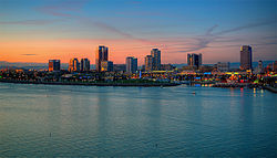
 42. Miami, Florida


 48. Tulsa, Oklahoma
 49. Tampa, Florida
 50. Arlington, Texas


