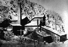
Lander, Nevada

Last updated
Lander, Nevada
USA Nevada location map.svg
Red pog.svg
Lander
Location within the state of Nevada
Usa edcp location map.svg
Red pog.svg
Lander
Lander (the United States)
Coordinates: 40°19′59″N116°42′23″W / 40.33306°N 116.70639°W / 40.33306; -116.70639 Coordinates: 40°19′59″N116°42′23″W / 40.33306°N 116.70639°W / 40.33306; -116.70639 [1]
Country United States
State Nevada
County Lander
Elevation
[1]
5,355 ft (1,632 m)
Time zone UTC-8 (Pacific (PST))
  Summer (DST) UTC-7 (PDT)
GNIS feature ID847387 [1]

Lander is a ghost town in Lander County in Nevada in the United States. The site is approximately 24 miles southeast of Battle Mountain. [1]

Contents

History

The town of Lander was established in the 1870s. [2] Early silver mines include the Silver Side, Grey Eagle and Lovie. [2] In 1883 there were 100 people in Lander. Several mills were built in that year and were open until 1885 when mills were closed. [3] Ore extraction was waning and stopped by 1890. Only temporary efforts were made after that year but a school was built in 1889 and was open until 1898 serving Lander and also Utah Mine camp and Mud Springs. In 1905, Charles Montgomery discovered gold 2 miles to the southeast of Lander, which became the site of Tenabo, Nevada. [2] In the summer of 1906 several were newly opened and were working. Lander had a post office from October 1906 until October 1909. [4] By 1907 Lander reached its peak with 75 residents. However the good times finished when mines were abandoned. Lander became in a ghost town and was abandoned in 1921. [3]

Related Research Articles

<span class="mw-page-title-main">Panamint City, California</span> Unincorporated community in California, United States

Panamint City is a ghost town in the Panamint Range, near Death Valley, in Inyo County, California, US. It is also known by the official Board of Geographic Names as Panamint. Panamint was a boom town founded after silver and copper were found there in 1872. By 1874, the town had a population of about 2,000. Its main street was one mile (1.6 km) long. Panamint had its own newspaper, the Panamint News. Silver was the principal product mined in the area. The town is located about three miles northwest of Sentinel Peak. According to the National Geographic Names Database, NAD27 latitude and longitude for the locale are 36°07′06″N117°05′43″W, and the feature ID number is 1661185. The elevation of this location is identified as being 6,280 feet AMSL. The similar-sounding Panamint Springs, California, is located about 25.8 miles at 306.4 degrees off true north near Panamint Junction.

<span class="mw-page-title-main">Belmont, Nevada</span> United States historic place

Belmont is a ghost town in Nye County, Nevada, United States along former State Route 82. The town is a historic district listed in the National Register of Historic Places. It is Nevada Historical Marker number 138.

Blair, Nevada is a mining ghost town in Esmeralda County, Nevada.

Etna is a former townsite, now a ghost town, in Pershing County, Nevada.

Vernon was a small mining town, now a ghost town, located in Pershing County, Nevada northwest of Lovelock.

<span class="mw-page-title-main">Wonder, Nevada</span> Ghost Town in Nevada, United States

Wonder, Nevada, is a ghost town in Churchill County, Nevada, approximately 39 miles (63 km) east of Fallon.

<span class="mw-page-title-main">Dun Glen, Nevada</span> Ghost Town in Nevada, United States

Dun Glen is a ghost town in Pershing County, Nevada, United States, 9 miles northeast of Mill City. Established in 1862, the mining camp soon became one of the largest towns in northern Nevada. By 1880, mining had declined and the town was abandoned. With a silver discovery in the area in 1908, the settlement attracted people and was re-named Chafey. Chafey was abandoned when mining operations stopped in 1913.

<span class="mw-page-title-main">Palmetto, Nevada</span> Ghost town in Nevada, United States

Palmetto, Nevada is a ghost town in Esmeralda County, in the U.S. state of Nevada.

<span class="mw-page-title-main">Fairview, Nevada</span> Historic site

Fairview is a ghost town in Churchill County, Nevada, in the United States of America.

<span class="mw-page-title-main">Argenta, Nevada</span> Ghost town in Nevada, United States

Argenta is a ghost town in Lander County, Nevada, in the United States.

Excelsior is a ghost town in Elko County, in the U.S. state of Nevada.

Eagleville is a former populated place in Mineral County, Nevada that is now a ghost town.

White Plains is a ghost town in Churchill County, in the U.S. state of Nevada.

<span class="mw-page-title-main">Seven Troughs, Nevada</span> Ghost town in Nevada, United States

Seven Troughs is a ghost town in Pershing County, Nevada, United States.

<span class="mw-page-title-main">Cortez, Nevada</span> Ghost town in Nevada, United States

Cortez is a ghost town in Lander County, in the U.S. state of Nevada. The GNIS classifies it as a populated place.

Johnnie is a populated place in Nye County, in the U.S. state of Nevada about 15 miles north of Pahrump.

<span class="mw-page-title-main">Bullionville, Nevada</span> Ghost town in Nevada, United States

Bullionville is a ghost town in Lincoln County, Nevada, United States, 1/4 mile east of U.S. Route 93, one mile north of Panaca and 10 miles (16 km) south of Pioche. The town prospered between 1870 and 1882, and is now abandoned.

Tempiute is a ghost town in Lincoln County, Nevada United States.

<span class="mw-page-title-main">Tenabo, Nevada</span> Ghost Town in Nevada, United States

Tenabo is a ghost town in Lander County, Nevada United States.

References

  1. 1 2 3 4 U.S. Geological Survey Geographic Names Information System: Lander, Nevada
  2. 1 2 3 Vanderburg, William O. (1939). Reconnaissance of Mining Districts in Lander County, Nevada (Report). U.S. Department of the Interior, Bureau of Mines. Retrieved January 7, 2020.
  3. 1 2 "Lander, Nevada". Ghosttowns.com. Retrieved July 13, 2014.
  4. U.S. Geological Survey Geographic Names Information System: Lander Post Office (historical)