
Clark County is a county located in the U.S. state of Nevada, which also comprises the Las Vegas-Henderson-North Las Vegas, NV Metropolitan Statistical Area. The land area of Clark County is 8,061 square miles (20,880 km2), or roughly the size of New Jersey. As of the 2020 census, the population was 2,265,461. Most of the county population resides in the Las Vegas Census County Divisions, which has 2,196,623 people as of the 2020 Census. It is by far the most populous county in Nevada, and the 11th-most populous county in the United States. It covers 7% of the state's land area but holds 73% of the state's population, making Nevada the most centralized state in the United States.

North Las Vegas is a suburban city in Clark County, Nevada, United States, in the Las Vegas Valley. As of the 2020 census it had a population of 262,527, with an estimated population of 280,543 in 2022. The city was incorporated on May 1, 1946. It is the 4th most populous city in the state of Nevada, and the 75th most populous city in the United States.

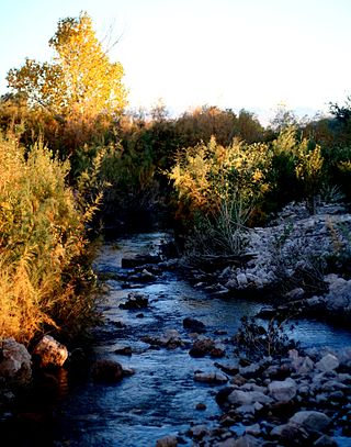
The Virgin River is a tributary of the Colorado River in the U.S. states of Utah, Nevada, and Arizona. The river is about 162 miles (261 km) long. It was designated Utah's first wild and scenic river in 2009, during the centennial celebration of Zion National Park.

The Las Vegas Valley is a major metropolitan area in the southern part of the U.S. state of Nevada, and the second largest in the Southwestern United States. The state's largest urban agglomeration, the Las Vegas Metropolitan Statistical Area is coextensive since 2003 with Clark County, Nevada. The Valley is largely defined by the Las Vegas Valley landform, a 600 sq mi (1,600 km2) basin area surrounded by mountains to the north, south, east and west of the metropolitan area. The Valley is home to the three largest incorporated cities in Nevada: Las Vegas, Henderson and North Las Vegas. Eleven unincorporated towns governed by the Clark County government are part of the Las Vegas Township and constitute the largest community in the state of Nevada.

The Amargosa River is an intermittent waterway, 185 miles (298 km) long, in southern Nevada and eastern California in the United States. The Amargosa River is one out of two rivers located in the California portion of the Mojave Desert with perennial flow. It drains a high desert region, the Amargosa Valley in the Amargosa Desert northwest of Las Vegas, into the Mojave Desert, and finally into Death Valley where it disappears into the ground aquifer. Except for a small portion of its route in the Amargosa Canyon in California and a small portion at Beatty, Nevada, the river flows above ground only after a rare rainstorm washes the region. A 26-mile (42 km) stretch of the river between Shoshone and Dumont Dunes is protected as a National Wild and Scenic River. At the south end of Tecopa Valley the Amargosa River Natural Area protects the habitat.

The ecology of the Sierra Nevada, located in the U.S. states of California and Nevada, is diverse and complex. The combination of climate, topography, moisture, and soils influences the distribution of ecological communities across an elevation gradient from 500 to 14,500 feet. Biotic zones range from scrub and chaparral communities at lower elevations, to subalpine forests and alpine meadows at the higher elevations. Particular ecoregions that follow elevation contours are often described as a series of belts that follow the length of the Sierra Nevada. There are many hiking trails, paved and unpaved roads, and vast public lands in the Sierra Nevada for exploring the many different biomes and ecosystems.
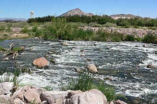
The Muddy River, formerly known as the Moapa River, is a short river located in Clark County, in southern Nevada, United States. It is in the Mojave Desert, approximately 60 miles (97 km) north of Las Vegas.

The Pahranagat Valley is a Tonopah Basin landform in Lincoln County, Nevada.
The Clark County Regional Flood Control District (CCRFCD) was created in 1985 by the Nevada Legislature allowing Clark County to provide broad solutions to flooding problems. The District has developed plans and so far successfully continued working on a 50-year program to eliminate most flooding from a 100-year flood in the populated areas for which the CCRFCD is responsible.
Las Vegas Wash is a 12-mile-long stream which feeds most of the Las Vegas Valley's excess water into Lake Mead. The wash is sometimes called an urban river, and it exists in its present capacity because of an urban population. The wash also works in a systemic conjunction with the pre-existing wetlands that formed the oasis of the Las Vegas Valley. The wash is fed by urban runoff, shallow ground water, reclaimed water used on parks and golf courses, and stormwater.

A ciénega is a wetland system unique to the American Southwest and Northern Mexico. Ciénagas are alkaline, freshwater, spongy, wet meadows with shallow-gradient, permanently saturated soils in otherwise arid landscapes that often occupy nearly the entire widths of valley bottoms. That description satisfies historic, pre-damaged ciénagas, although few can be described that way now. Incised ciénagas are common today. Ciénagas are usually associated with seeps or springs, found in canyon headwaters or along margins of streams. Ciénagas often occur because the geomorphology forces water to the surface, over large areas, not merely through a single pool or channel. In a healthy ciénaga, water slowly migrates through long, wide-scale mats of thick, sponge-like wetland sod. Ciénaga soils are squishy, permanently saturated, highly organic, black in color or anaerobic. Highly adapted sedges, rushes and reeds are the dominant plants, with succession plants—Goodding's willow, Fremont cottonwoods and scattered Arizona walnuts—found on drier margins, down-valley in healthy ciénagas where water goes underground or along the banks of incised ciénagas.

Coyote Springs, Nevada, is a master-planned community being developed in Lincoln County and Clark County, Nevada. The community was initially planned by developer and attorney-lobbyist Harvey Whittemore and Pardee Homes. Thomas Seeno and Albert Seeno, Jr. became the sole owners of Coyote Springs following Whittemore's resignation from the Wingfield Nevada Holding Group amidst legal troubles. No homes had been built as of June 2018.
The Provo River is located in Utah County and Wasatch County, Utah, in the United States. It rises in the Uinta Mountains at Wall Lake and flows about 71 miles (114 km) southwest to Utah Lake at the city of Provo, Utah.

Tolay Lake is a shallow freshwater lake in southern Sonoma County, California, United States. The lake, nestled within the southern vestiges of the Sonoma Mountains, is the site of significant Native American prehistoric seasonal settlement. In 2005, Sonoma County acquired the entirety of the lake and virtually its whole drainage basin from the Cardoza family for the sum of $18 million; the county's intention is to utilize the property as Tolay Lake Regional Park for ecological and archaeological preservation, as well as public use and enjoyment. Tolay Lake and its immediate drainage area is home to several nesting pairs of golden eagles, Aquila chrysaetos, and a number of rare, threatened or endangered species including the California red-legged frog, Rana draytonii; Western pond turtle, Actinemys marmorata; and Western burrowing owl, Athene cunicularia.

A beaver dam or beaver impoundment is a dam built by beavers; it creates a pond which protects against predators such as coyotes, wolves and bears, and holds their food during winter. These structures modify the natural environment in such a way that the overall ecosystem builds upon the change, making beavers a keystone species and ecosystem engineers. They build prolifically at night, carrying mud with their forepaws and timber between their teeth.

Smith and Bybee Wetlands Natural Area is a public park and nature reserve between the Columbia Slough and the Columbia River in Portland, Oregon. At about 2,000 acres (810 ha), it is one of the largest urban freshwater wetlands in the United States. Metro, the regional government for the Oregon part of the Portland metropolitan area, manages the park. A covered shelter, restrooms, a paved walkway, and a canoe launch lie on the north side of the natural area.

Vega State Park is a 1,823-acre (738 ha) Colorado state park in Mesa County, Colorado in the United States. Vega Reservoir is a fishing destination and is located at an elevation of 7,696 feet (2,346 m). Year-round recreational activities at Vega State Park include boating, hiking, snowmobiling and camping. The park was established in 1967 in cooperation with the Bureau of Reclamation which was responsible for the construction of Vega Dam and Vega Reservoir. It is located at the northeast edge of Grand Mesa National Forest in Western Colorado.

The Yanga National Park is a newly formed national park, located near the township of Balranald in south- western New South Wales. It covers an area of 66,734 hectares which includes 1,932 hectares of Yanga Nature Reserve, and has a frontage of 170 kilometres (110 mi) on the Murrumbidgee River. It is largely located in the Lower Murrumbidgee Floodplain, which is included on A Directory of Important Wetlands in Australia because of its importance as a breeding site for waterbirds when flooded.

The Las Vegas Tribe of Paiute Indians of the Las Vegas Indian Colony is a federally recognized tribe of Southern Paiute Indians in Southern Nevada.

Blue Diamond Hill is a 4,931-foot (1,503 m) peak that borders Red Rock Canyon in Nevada, west of Las Vegas. The Blue Diamond Mine is located on the hill, and the small community of Blue Diamond, Nevada is located nearby. Several housing projects have been proposed for the hill since 2002.

