U.S. Route 91 or U.S. Highway 91 (US-91) is a 172.663-mile-long (277.874 km) north–south United States highway running from Brigham City, Utah to Idaho Falls, Idaho in the U.S. states of Idaho and Utah. Despite the "1" as the last digit in the number, US-91 is no longer a cross country artery. The highway currently serves to connect the communities of the Cache Valley to Interstate 15 and beyond. Prior to the mid-1970s, US 91 was an international commerce route from Long Beach, California to the Canada–US border north of Sweetgrass, Montana. US 91 was routed on the main streets of most of the communities it served, including Las Vegas Boulevard in Las Vegas and State Street in Salt Lake City. From Los Angeles to Salt Lake, the route was built along the corridor of the Arrowhead Trail. US 91 has been largely replaced by Interstate 15. A portion of the highway's former route in California is currently State Route 91.
U.S. Route 466 was an east–west United States highway. Though it reached a length of around 500 miles (805 km), the route was co-signed with other US routes for much of its length. When California deleted most of its U.S. Highways in the mid-1960s, including US 466 in 1964, there was no longer a need for the designation.
The Las Vegas Beltway is a 50.3-mile (81.0 km) beltway route circling three-quarters of the Las Vegas Valley in southern Nevada. The Las Vegas Beltway carries two numerical designations. Approximately 11.1 miles (17.9 km) of the highway, from its southern terminus at Interstate 11/Interstate 515/U.S. Route 93/U.S. Route 95 in Henderson west and northwest to Interstate 15, is signed as Interstate 215 (I-215); however, only two distinct portions of this section, totaling a little over 4.6 miles (7.4 km), are maintained by the Nevada Department of Transportation. Clark County Route 215 composes the remaining 39.2 miles (63.1 km) of this semi-circumferral highway, with the county's Department of Public Works responsible for all construction and maintenance.
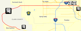
State Route 159 is a 31.204-mile (50.218 km) east–west highway in Clark County, Nevada, United States, providing access to Red Rock Canyon and serving as a thoroughfare in the Las Vegas metropolitan area. A portion of the west end of the route is designated a Nevada Scenic Byway.

State Route 147 is a state highway serving the Las Vegas Valley in southern Nevada. It is signed as Lake Mead Boulevard and runs from Interstate 15 (I-15) and U.S. Route 93 in North Las Vegas east to the border of the Lake Mead National Recreation Area. It is not to be confused with Lake Mead Parkway, which also goes to Lake Mead but mainly runs in southern Las Vegas Valley and carries the designation of State Route 564.
State Route 604 is the route number designation for parts of Las Vegas Boulevard, a major north–south road in the Las Vegas metropolitan area of Nevada in the United States best known for the Las Vegas Strip and its casinos. Formerly carrying U.S. Route 91, which had been the main highway between Los Angeles and Salt Lake City, it has been bypassed by Interstate 15 and serves mainly local traffic.
State Route 595 comprises a portion of Rainbow Boulevard, a north–south section line arterial in the Las Vegas Valley.
State Route 596 (SR 596) comprises a 4.088-mile (6.579 km) portion of Jones Boulevard, a section line arterial that runs north and south through the Las Vegas Valley.
State Route 599 is a 7.049-mile (11.344 km) state highway in Clark County, Nevada. The route follows Rancho Drive, a major arterial connecting downtown Las Vegas to the northwest part of the city. Much of SR 599 was previously designated as U.S. Route 95 prior to completion of the Las Vegas Expressway. The route is also designated as U.S. Route 95 Business.
State Route 579 is a state highway in Clark County, Nevada. It follows a portion of Bonanza Road near the downtown area of Las Vegas. The route encompasses a small portion of former State Route 5 and the entirety of former State Route 5A, and also carried U.S. Route 95 before it was relocated to its present freeway alignment.
State Route 602 is a short state highway in Clark County, Nevada. Located entirely within the downtown area of Las Vegas, it comprises a small section of Casino Center Boulevard. The route was previously a part of State Route 5B. The highway now primarily serves as a connection between State Route 579 and Interstate 515.
State Route 578 is a short state highway in Clark County, Nevada. It comprises a 0.661-mile (1.064 km) portion of Washington Avenue in Las Vegas.
Spring Mountain Road is a major east-west road in the Las Vegas Valley. It runs from Hualapai Way at its western terminus to Las Vegas Boulevard in the east. East of Las Vegas Boulevard, Spring Mountain becomes Sands Avenue, and then jogs south to join Twain Avenue. State Route 591 was a state highway that comprised a 0.242-mile (0.389 km) section of Spring Mountain at Interstate 15.
Tropicana Avenue is a major east–west section line arterial in the Las Vegas area. The road is named after Tropicana Las Vegas which is located on the Las Vegas Boulevard where it intersects with Tropicana Avenue. Part of it is signed as Nevada State Route 593.
Russell Road is a section line road within the Las Vegas Valley of Clark County, Nevada. It is no longer a continuous road through the valley, as McCarran International Airport interrupts its right of way. The eastern section terminates at the eastern edge of the airport, with the road resuming at Las Vegas Boulevard on the western edge of the airport. The intersection of Russell Road and Las Vegas Boulevard is often considered to mark the southern terminus of the Las Vegas Strip.
State Route 582 (SR 582) is a major 15.392-mile-long (24.771 km) highway in the Las Vegas Valley. The highway is the former route of U.S. Route 93 (US 93) and US 95 before they were moved to the current freeway alignment shared with Interstate 11 (I-11) and Interstate 515 (I-515). Known primarily as Boulder Highway, the route connects Downtown Las Vegas with Henderson and Boulder City to the southeast.
State Route 564 is an east–west highway in Clark County, Nevada, in the southeast portion of the Las Vegas Valley. The route travels through the city of Henderson, traveling from the junction of Interstate 215 (I-215) and I-11 south and I-515 north, also part of U.S. Route 93 and US 95, to Lake Las Vegas, ending near Lake Mead. The route was designated in 2002, replacing a portion of SR 146.
State Route 605 was a north–south state highway in the Las Vegas urban area. SR 605 comprised a portion of Paradise Road. The route was turned over to local control in 2001.

U.S. Route 95 is a major U.S. highway traversing the U.S. state of Nevada from north to south directly through Las Vegas and providing connections to both Carson City and Reno. US 95 is cosigned with Interstate 80 for 95 miles (153 km) between a junction in Trinity and Winnemucca before heading north into Oregon at McDermitt. At 646 miles, it is the longest highway in Nevada.
The McCarran Airport Connector (MAC) is a limited-access roadway system located in Paradise, an unincorporated town in the Las Vegas Valley, Clark County, Nevada, United States. Composed of State Route 171, the Airport Tunnel and arterial streets, the airport connector provides vehicular access to the passenger terminals at McCarran International Airport. Despite being completely owned by Clark County, the first 0.685 miles (1.102 km) of the McCarran Airport Connector is maintained by NDOT as unsigned SR 171, while the remaining section is maintained by Clark County.

