
The Ansel Adams Wilderness is a wilderness area in the Sierra Nevada of California, United States. The wilderness spans 231,533 acres (93,698 ha); 33.9% of the territory lies in the Inyo National Forest, 65.8% is in the Sierra National Forest, and the remaining 0.3% covers nearly all of Devils Postpile National Monument. Yosemite National Park lies to the north and northwest, while the John Muir Wilderness lies to the south.

The Humboldt–Toiyabe National Forest (HTNF) is the principal U.S. National Forest in the U.S. state of Nevada, and has a smaller portion in Eastern California. With an area of 6,289,821 acres (25,454.00 km2), it is the largest U.S. National Forest outside of Alaska.

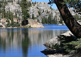
The John Muir Wilderness is a wilderness area that extends along the crest of the Sierra Nevada of California for 90 miles (140 km), in the Inyo and Sierra National Forests. Established in 1964 by the Wilderness Act and named for naturalist John Muir, it encompasses 652,793 acres (2,641.76 km2). The wilderness lies along the eastern escarpment of the Sierra from near Mammoth Lakes and Devils Postpile National Monument in the north, to Cottonwood Pass near Mount Whitney in the south. The wilderness area also spans the Sierra crest north of Kings Canyon National Park, and extends on the west side of the park down to the Monarch Wilderness.

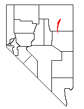
The East Humboldt Range is a mountain range in Elko County, Nevada, United States. It is located along the eastern edge of the upper watershed of the Humboldt River, which flows to the southwest from its source just north of the range. The range reaches a maximum elevation of 11,306 feet (3,446 m) atop Hole in the Mountain Peak. Most of the range is included within the Ruby Mountains Ranger District of the Humboldt-Toiyabe National Forest. In 1989, the United States Congress passed the Nevada Wilderness Protection Act establishing over 36,000 acres (150 km2) of the range as the East Humboldt Wilderness. The range takes its name from the Humboldt River. The name ultimately is derived from the German naturalist Alexander von Humboldt.
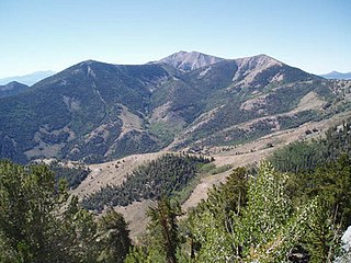
The Santa Rosa Range is a mountain range in Humboldt County, Nevada, United States. Most of the range is included within the Humboldt-Toiyabe National Forest. The highest peaks in the range are Granite Peak and Santa Rosa Peak. The range extends for approximately 75 miles (120 km) north from Winnemucca Mountain near Winnemucca through eastern Humboldt County to the border with Oregon. The upper elevations of the southern section of the range are protected as the Santa Rosa-Paradise Peak Wilderness Area.

The Toiyabe Range is a mountain range in Lander and Nye counties, Nevada, United States. Most of the range is included within the Humboldt-Toiyabe National Forest. The highest point in the range, near its southern end, is Arc Dome, an area protected as the Arc Dome Wilderness. The highest point in Lander County, Bunker Hill, is also located within the Toiyabe Range. The range starts in northwestern Nye County north of Tonopah, Nevada and runs approximately 120 miles (190 km) north-northeast into southern Lander County, making it the second longest range in the state.
The Ruby Mountains are a mountain range, primarily located within Elko County with a small extension into White Pine County, in Nevada, United States. Most of the range is included within the Humboldt-Toiyabe National Forest. The range reaches a maximum elevation of 11,387 feet (3,471 m) on the summit of Ruby Dome. To the north is Secret Pass and the East Humboldt Range, and from there the Rubies run south-southwest for about 80 miles (130 km). To the east lies Ruby Valley, and to the west lie Huntington and Lamoille Valleys. The Ruby Mountains are the only range of an introduced bird, the Himalayan snowcock, in North America. The mountain range was named after the garnets found by early explorers. The central core of the range shows extensive evidence of glaciation during recent ice ages, including U-shaped canyons, moraines, hanging valleys, and steeply carved granite mountains, cliffs, and cirques.
The Emigrant Wilderness of Stanislaus National Forest is a formally designated wilderness area in the Sierra Nevada. It is bordered by Yosemite National Park on the south, the Toiyabe National Forest and the Hoover Wilderness on the east, and State Route 108 over Sonora Pass on the north. It is an elongated area that extends northeast about 25 miles (40 km) in length and up to 15 miles (24 km) in width. Watersheds drain to the Stanislaus and Tuolumne Rivers. The Emigrant Wilderness area, which is a glaciated landscape, is entirely within Tuolumne County, California and is approximately 140 miles (230 km) east of San Francisco, California and 50 miles (80 km) south of Lake Tahoe.

Eldorado National Forest is a U.S. National Forest located in the central Sierra Nevada mountain range, in eastern California.

The Snake Range is a mountain range in White Pine County, Nevada, United States. The south-central portion of the range is included within Great Basin National Park, with most of the remainder included within the Humboldt-Toiyabe National Forest. The range reaches a maximum elevation of 13,065 feet (3,982 m) at the summit of Wheeler Peak, the tallest independent mountain within Nevada and the second highest point within the state. The range also contains four of the five highest mountain peaks in Nevada, including all peaks greater than 12,000 feet (3,658 m) except for Boundary Peak.
In 1989 the U.S. Government enacted the Nevada Wilderness Bill, expanding the one existing Wilderness Area (Jarbidge) and creating thirteen new areas. The estimated total of 733,400 acres (296,800 ha) was over eleven times the area that had previously been under wilderness protection.
The Grant Range Wilderness is a protected wilderness area in the Grant Range of Nye County, in the central section of the state of Nevada in the western United States.

The Mt. Moriah Wilderness is a 89,790-acre (36,340 ha) wilderness area in the northern part of the Snake Range of White Pine County, in the eastern section of the state of Nevada in the western United States.

Jennie Lakes Wilderness is a protected area in the Sierra Nevada, in Tulare County, California. It is located 60 miles (97 km) east of Fresno and managed by the US Forest Service. Jennie Lakes Wilderness is about nine square miles within the Sequoia National Forest, that was established by the California Wilderness Act of 1984, and added to the National Wilderness Preservation System.
The High Schells Wilderness is a 121,497-acre (49,168 ha) wilderness area in the Schell Creek Range of White Pine County, in the U.S. state of Nevada. The Wilderness lies within the Humboldt-Toiyabe National Forest and is therefore administered by the U.S. Forest Service.
The South Sierra Wilderness is a federally designated wilderness area in the Southern Sierra Nevada, in eastern California. It is located 65 miles (105 km) northeast of Bakersfield, and is southwest of Owens Lake and Olancha.
The Carson–Iceberg Wilderness is a federal wilderness area located 80 miles (130 km) northeast of Stockton, California. It encompasses 160,000 acres (650 km2) and was designated by the California Wilderness Act of 1984. It protects an area of High Sierra landscape with elevations from 4,800 feet (1,500 m) to 11,462 feet (3,494 m) along the Sierra Mountains from Ebbetts Pass to Sonora Pass in the south. The US Forest Service manages the wilderness which is in both the Stanislaus National Forest and the Humboldt–Toiyabe National Forest.

The Mokelumne Wilderness is a 105,165-acre federally designated wilderness area located 70 miles (110 km) east of Sacramento, California. It is within the boundaries of three national forests: Stanislaus, Eldorado and Toiyabe. First protected under the Wilderness Act of 1964, the Mokelumne's borders were expanded under the California Wilderness Act of 1984 with the addition of 55,000 acres. The wilderness takes its name from the Mokelumne River, which was named after a Mi-wok Indian village located on the riverbank in California's Central Valley.

Manzano Mountain Wilderness is a designated Wilderness Area within the Cibola National Forest, located about 50 miles (80 km) south-southeast of Albuquerque. It is located in western Torrance County and eastern Valencia County. The Wilderness area includes 36,875 acres (14,923 ha) with elevations ranging from 6,100 feet (1,900 m) to 10,098 feet (3,078 m) at Manzano Peak.
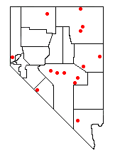
The protected areas of the Sierra Nevada, a major mountain range located in the U.S. states of California and Nevada, are numerous and highly diverse. Like the mountain range itself, these areas span hundreds of miles along the length of the range, and over 14,000 feet of elevation from the lowest foothills to the summit of Mount Whitney.


