Clark County is a county located in the U.S. state of Nevada, which also comprises the Las Vegas-Henderson-North Las Vegas, NV metropolitan statistical area. The land area of Clark County is 8,061 square miles (20,880 km2), or roughly the size of New Jersey. As of the 2020 census, the population was 2,265,461. Most of the county population resides in the Las Vegas Census County Divisions, which has 2,196,623 people as of the 2020 Census. It is by far the most populous county in Nevada, and the 11th-most populous county in the United States. It covers 7% of the state's land area but holds 73% of the state's population, making Nevada the most centralized state in the United States.

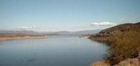
Lake Mead is a reservoir formed by the Hoover Dam on the Colorado River in the Southwestern United States. It is located in the states of Nevada and Arizona, 24 mi (39 km) east of Las Vegas. It is the largest reservoir in the US in terms of water capacity. Lake Mead provides water to the states of Arizona, California, and Nevada as well as some of Mexico, providing sustenance to nearly 20 million people and large areas of farmland.
Lake Mead National Recreation Area is a U.S. national recreation area in Southeastern Nevada and Northwestern Arizona. Operated by the National Park Service, Lake Mead NRA follows the Colorado River corridor from the westernmost boundary of Grand Canyon National Park to just north of the cities of Laughlin, Nevada and Bullhead City, Arizona. It includes all of the eponymous Lake Mead as well as the smaller Lake Mohave – reservoirs on the river created by Hoover Dam and Davis Dam, respectively – and the surrounding desert terrain and wilderness.
The Palen Mountains are located in the southern Mojave Desert – northern Colorado Desert in eastern Riverside County, California, US. The range lies southeast of the Coxcomb Mountains, and northeast of the Chuckwalla Mountains near Interstate 10. The mountains lie in a southwest-northeasterly direction and are approximately 15 miles long and nine miles wide at their widest point.

The Whipple Mountains are located in eastern San Bernardino County, California. They are directly west of the Colorado River, Parker Dam, and Lake Havasu; south of Needles, California; north of Parker, Arizona and Vidal, California; and northeast of Vidal Junction, California.

The Fish Creek Mountains Wilderness is located about 25 miles west of Brawley, California, and southeast of the Vallecito Mountains in the United States. The wilderness is located in the Fish Creek Mountains region in the northern part of the Carrizo Impact Area, which is closed to the public.
The Newberry Mountains in Nevada are located east of Cal-Nev-Ari and the United States Coast Guard LORAN station in the southern part of the state. The range is Nevada's southernmost named mountain range, and lies to the northwest of the town of Laughlin and west of Lake Mohave. The Newberry Mountains connect with the Eldorado Mountains and The Highland Mountains. The highest point in the range is Spirit Mountain at 5,642 feet (1,720 m).
Colonel Bob Wilderness is a 11,855-acre (4,798 ha) protected area located in the southwest corner of Olympic National Forest in the state of Washington. It is named after 19th-century orator Robert Green Ingersoll. Lake Quinault lies about 15 miles to the west. Elevations in the wilderness vary from 300 to 4,509 feet above sea level. The highest elevation is an unnamed peak; the second-highest elevation is Colonel Bob Mountain at 4,492 feet. The wilderness is a temperate rain forest with annual rainfall greater than 150 inches (3,800 mm).

The Deseret Peak Wilderness is located in the Stansbury Mountains of Tooele County, Utah, United States near the towns of Tooele and Grantsville, not far from the Great Salt Lake. It is part of the Wasatch-Cache National Forest. This semi-arid wilderness is part of the Great Basin ecosystem. Elevations range from about 6,000 feet to the top of Deseret Peak's limestone escarpment at 11,031 feet (3,362 m). In this high country, with barren Skull Valley to the west, you'll find some springs and intermittent creeks, despite the general dryness of the area.
Theodore Roosevelt Lake is a large reservoir formed by Theodore Roosevelt Dam on the Salt River in Arizona as part of the Salt River Project (SRP). Located roughly 80 miles (130 km) northeast of Phoenix in the Salt River Valley, Theodore Roosevelt is the largest lake or reservoir located entirely within the state of Arizona. The reservoir and the masonry dam that created it, Roosevelt Dam, were both named after U.S. President Theodore Roosevelt who dedicated the dam himself on March 18, 1911. Roosevelt Lake is a popular recreation destination within the Tonto National Forest; the facilities located at this lake are managed by that authority.

The Darwin Falls Wilderness is a protected area in the northern Mojave Desert adjacent to Death Valley National Park. The 8,189-acre (3,314 ha) wilderness area was created by the California Desert Protection Act of 1994 and is managed by the Bureau of Land Management as part of the National Wilderness Preservation System.

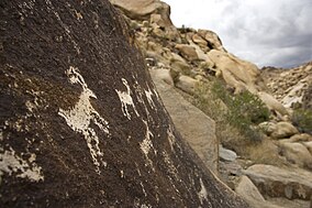
The Grapevine Canyon Petroglyphs are located in Grapevine Canyon on Spirit Mountain near Laughlin, Nevada, and are listed on the United States National Register of Historic Places. The area is also known as Christmas Tree Pass. While the petroglyphs extend through the canyon, a significant concentration lies at the entrance to the canyon which is at an elevation of 2,395 feet (730 m). The area features over 700 petroglyphs and many rock shelters.
The Black Mountains, a mid-Miocene formation, in Nevada are a series of rugged, arid rocky volcanic mountains ranging in elevations to 3310 ft. The range lies on the north shore of Lake Mead, at the southwest corner of the Overton Arm, about 25 mi south of Overton, Nevada.

The Eldorado Mountains, also called the El Dorado Mountains, are a north-south trending mountain range in southeast Nevada bordering west of the south-flowing Colorado River; the endorheic Eldorado Valley borders the range to the west, and the range is also on the western border of the Colorado River's Black Canyon of the Colorado, and El Dorado Canyon on the river. The range is 50 miles (80 km) southeast of Las Vegas, Nevada; and the Eldorado Mountains connect with the Highland and Newberry mountains.
Bristlecone Wilderness is a 14,095-acre (5,704 ha) wilderness area in White Pine County, in the U.S. state of Nevada. Located in the Egan Range approximately five miles west of the town of Mcgill, the Wilderness was created by the "White Pine County Conservation, Recreation and Development Act of 2006" and is administered by the U.S. Bureau of Land Management.

Spirit Mountain Wilderness Area is a 33,518-acre (13,564 ha) wilderness area located in the Newberry Mountains in Clark County, Nevada, 10 miles (16 km) northwest of Laughlin. Spirit Mountain lies within the area. It is managed by the Bureau of Land Management and the National Park Service.
The Black Canyon Wilderness in the state of Nevada is a 17,220-acre (6,970 ha) wilderness area located in the Dry Lake Watershed along Dry Lake Valley at Black Canyon of the Colorado, west of the Great Basin Divide. It is part of the Lake Mead National Recreation Area. Immediately to the south is the Eldorado Wilderness, in the El Dorado Mountains. Together, the two wilderness areas protect 49,170 acres (19,900 ha).

The Colorado River is a major river of the western United States and northwest Mexico in North America. Its headwaters are in the Rocky Mountains where La Poudre Pass Lake is its source. Located in north central Colorado it flows southwest through the Colorado Plateau country of western Colorado, southeastern Utah and northwestern Arizona where it flows through the Grand Canyon. It turns south near Las Vegas, Nevada, forming the Arizona–Nevada border in Lake Mead and the Arizona–California border a few miles below Davis Dam between Laughlin, Nevada and Needles, California before entering Mexico in the Colorado Desert. Most of its waters are diverted into the Imperial Valley of Southern California. In Mexico its course forms the boundary between Sonora and Baja California before entering the Gulf of California. This article describes most of the major features along the river.

The Grand Wash Cliffs extend south-southeast from the Grand Canyon-Parashant National Monument in northwest Arizona west of the Shivwits Plateau south through the Grand Cliffs Wilderness and into the Lake Mead Recreation Area. The Grand Wash Cliffs cross the Grand Canyon where the Colorado River enters Lake Mead. To the south of the Grand Canyon the Grand Wash Cliffs continue past the east side of Grapevine Mesa and then southeast above and east of the Hualapai Valley forming the southwest margin of the Music Mountains.
Jimbilnan Wilderness is an 18,879 acre wilderness area that starts from the northeast side of the Black Mountains and extends eastward towards Lake Mead. On its west side lies Pinto Valley Wilderness Park, and Las Vegas can be found 40 miles (64 km) west from the area. Jimbilnan Wilderness was designated as a wilderness area in 2002 and is under the management of the National Park Service.