Clark County is located in the U.S. state of Nevada. As of the 2020 census, the population was 2,265,461. Most of the county population resides in the Las Vegas Census County Divisions, which hold 1,771,945 people as of the 2010 Census, across 476 square miles (1,230 km2). It is by far the most populous county in Nevada, and the 11th most populous county in the United States. It covers 7% of the state's land area but holds 74% of the state's population, making Nevada one of the most centralized states in the United States.

Mohave County is in the northwestern corner of the U.S. state of Arizona. As of the 2020 census, its population was 213,267. The county seat is Kingman, and the largest city is Lake Havasu City. It is the fifth largest county in the United States.

The Red Rock Canyon National Conservation Area in Clark County, Nevada, is an area managed by the Bureau of Land Management as part of its National Landscape Conservation System, and protected as a National Conservation Area. It is about 15 miles (24 km) west of Las Vegas, and is easily seen from the Las Vegas Strip. More than three million people visit the area each year.

The Mojave Desert is a desert in the rain shadow of the Sierra Nevada mountains in the Southwestern United States. It is named for the indigenous Mojave people. It is located primarily in southeastern California and southwestern Nevada, with small portions extending into Arizona and Utah.

The Mojave River is an intermittent river in the eastern San Bernardino Mountains and the Mojave Desert in San Bernardino County, California, United States. Most of its flow is underground, while its surface channels remain dry most of the time, except for the headwaters and several bedrock gorges in the lower reaches.

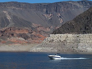
Lake Mead is a reservoir formed by the Hoover Dam on the Colorado River in the Southwestern United States. It is located in the states of Nevada and Arizona, 24 mi (39 km) east of Las Vegas. It is the largest reservoir in the US in terms of water capacity. Lake Mead provides water to the states of Arizona, California, and Nevada as well as some of Mexico, providing sustenance to nearly 20 million people and large areas of farmland.

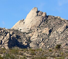
Bridge Mountain is a mountain located in the Spring Mountain range of southern Nevada. It is located on land managed by the United States Bureau of Land Management as the Red Rock Canyon National Conservation Area, part of the Rainbow Mountain Wilderness. Bridge Mountain is named for the natural feature of a bridge-like natural arch of sandstone near the summit.
Lake Mead National Recreation Area is a U.S. national recreation area in southeastern Nevada and northwestern Arizona. Operated by the National Park Service, Lake Mead NRA follows the Colorado River corridor from the westernmost boundary of Grand Canyon National Park to just north of the cities of Laughlin, Nevada and Bullhead City, Arizona. It includes all of the eponymous Lake Mead as well as the smaller Lake Mohave – reservoirs on the river created by Hoover Dam and Davis Dam, respectively – and the surrounding desert terrain and wilderness.

Sloan Canyon National Conservation Area is a National Conservation Area (NCA) administered by the United States Bureau of Land Management (BLM). It includes the Sloan Petroglyph Site which was listed on the National Register of Historic Places on December 19, 1978. It is located south of Las Vegas, Nevada, access is available from Las Vegas Boulevard, near the Del Webb Anthem development in Henderson. Sloan Canyon NCA protects 48,438 acres (19,602 ha).

The Old Spanish Trail is a historical trade route that connected the northern New Mexico settlements of Santa Fe, New Mexico with those of Los Angeles, California and southern California. Approximately 700 mi (1,100 km) long, the trail ran through areas of high mountains, arid deserts, and deep canyons. It is considered one of the most arduous of all trade routes ever established in the United States. Explored, in part, by Spanish explorers as early as the late 16th century, the trail was extensively used by traders with pack trains from about 1830 until the mid-1850s.

Lake Mohave is a reservoir on the Colorado River between the Hoover Dam and Davis Dam in Cottonwood Valley defining the border between Nevada and Arizona in the United States. This 67 mile stretch of the Colorado River flows past Boulder City, Nelson, Searchlight, Cottonwood Cove, Cal-Nev-Ari, and Laughlin to the west in Nevada and Willow Beach and Bullhead City to the east in Arizona. A maximum width of 4 miles wide and an elevation of 647 feet (197 m), Lake Mohave encompasses 28,260 acres of water. As Lake Mead lies to the north of the Hoover Dam, Lake Mohave and adjacent lands forming its shoreline are part of the Lake Mead National Recreation Area administered by the U.S. National Park Service.
The Newberry Mountains in Nevada are located east of Cal-Nev-Ari and the United States Coast Guard LORAN station in the southern part of the state. The range is Nevada's southernmost named mountain range, and lies to the northwest of the town of Laughlin and west of Lake Mohave. The Newberry Mountains connect with the Eldorado Mountains and The Highland Mountains. The highest point in the range is Spirit Mountain at 5,642 feet (1,720 m).
Sloan is an unincorporated community with a population of 105 in Clark County, Nevada, situated 18 miles southwest of Las Vegas. It is named for its limestone dolomite carnotite and was first settled in 1912 under the name Ehret; named for the founders' family name, but changed its name to Sloan on September 11, 1922. It is known for its canyon and its Sloan Canyon Petroglyph Site, Petroglyph Canyon, Black Mountain and is mostly located within the North McCullough Wilderness Area and is adjacent to the McCullough Range. It contains well-preserved petroglyphs and several hiking trails that allow visitors to photograph the petroglyphs. Sloan is also home to the George W. Dunaway Army Reserve Center which officially opened in April 2015, which is a large military area not open to the public. 2.7 miles west of Sloan was the site of the Bonanza Air Lines Flight 114 accident, which killed 29 people. Most of the residential areas are located on the main street, Sloan Road, and other smaller roads such as Arville Street, Hinston Street, and Roark Avenue. It is adjacent to Interstate 15 and is accessible from exit 25. The Sloan Canyon visitors center and trailhead to the Petroglyphs are accessible from a newer paved road through the Henderson neighborhood of Anthem, east of Interstate 15.

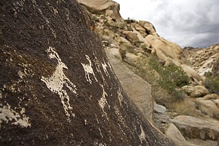
The Grapevine Canyon Petroglyphs are located in Grapevine Canyon on Spirit Mountain near Laughlin, Nevada, and are listed on the United States National Register of Historic Places. The area is also known as Christmas Tree Pass. While the petroglyphs extend through the canyon, a significant concentration lies at the entrance to the canyon which is at an elevation of 2,395 feet (730 m). The area features over 700 petroglyphs and many rock shelters.

The Eldorado Mountains, also called the El Dorado Mountains, are a north-south trending mountain range in southeast Nevada bordering west of the south-flowing Colorado River; the endorheic Eldorado Valley borders the range to the west, and the range is also on the western border of the Colorado River's Black Canyon of the Colorado, and El Dorado Canyon on the river. The range is 50 miles (80 km) southeast of Las Vegas, Nevada; and the Eldorado Mountains connect with the Highland and Newberry mountains.

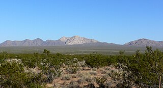
Spirit Mountain Wilderness Area is a 33,518-acre (13,564 ha) wilderness area located in the Newberry Mountains in Clark County, Nevada, 10 miles (16 km) northwest of Laughlin. Spirit Mountain lies within the area. It is managed by the Bureau of Land Management and the National Park Service.
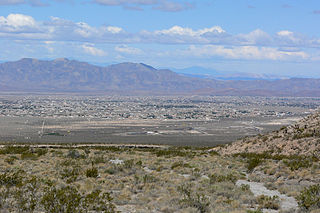
Pahrump Valley is a Mojave Desert valley west of Las Vegas and the Spring Mountains massif in southern Nye County, Nevada, and eastern San Bernardino County, California. Pahrump, Nevada, is in the valley's center and the Tecopa and Chicago Valleys are immediately to the west. The valley has routes to Death Valley and a route to Las Vegas. Pahrump Valley Days is the annual event in February each year, along with the sanctioned JRH-HS Rodeo.

The Colorado River is a major river of the western United States and northwest Mexico in North America. Its headwaters are in the Rocky Mountains where La Poudre Pass Lake is its source. Located in north central Colorado it flows southwest through the Colorado Plateau country of western Colorado, southeastern Utah and northwestern Arizona where it flows through the Grand Canyon. It turns south near Las Vegas, Nevada, forming the Arizona–Nevada border in Lake Mead and the Arizona–California border a few miles below Davis Dam between Laughlin, Nevada and Needles, California before entering Mexico in the Colorado Desert. Most of its waters are diverted into the Imperial Valley of Southern California. In Mexico its course forms the boundary between Sonora and Baja California before entering the Gulf of California. This article describes most of the major features along the river.
The Bridge Canyon Wilderness is a small wilderness area located in the Newberry Mountains in southern Nevada, United States, in the Lake Mead National Recreation Area. The rock outcrops and caves make this area very striking. Stands of cottonwood trees can be found along the Grapevine Wash and Sacatone Wash water courses. Canyon grape, cattails and rushes grow in Grapevine Canyon. Discover the petroglyphs of early Native Americans in the canyon. Reptiles include the Western chuckwalla, side-blotched lizard, and Gila monster.
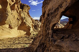
Gold Butte National Monument is a United States national monument located in Clark County, Nevada, northeast of Las Vegas and south of Mesquite and Bunkerville. The monument protects nearly 300,000 acres of desert landscapes featuring a wide array of natural and cultural resources, including rock art, sandstone towers, and important wildlife habitat for species including the Mojave Desert tortoise, bighorn sheep, and mountain lion. The area also protects historic ranching and mining sites such as the ghost town of Gold Butte, although little but mine openings, cement foundations, and a few pieces of rusting equipment remains. The monument is managed by the Bureau of Land Management.