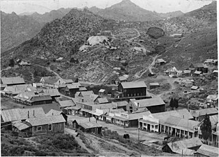
Bodie is a ghost town in the Bodie Hills east of the Sierra Nevada mountain range in Mono County, California, United States. It is about 75 miles (121 km) southeast of Lake Tahoe, and 12 mi (19 km) east-southeast of Bridgeport, at an elevation of 8,379 feet (2554 m). Bodie became a boom town in 1876 after the discovery of a profitable vein of gold; by 1879 it had established 2,000 structures with a population of roughly 8,000 people.

Malakoff Diggins State Historic Park is a state park unit preserving Malakoff Diggins, the largest hydraulic mining site in California, United States. The mine was one of several hydraulic mining sites at the center of the 1882 landmark case Woodruff v. North Bloomfield Mining and Gravel Company. The mine pit and several Gold Rush-era buildings are listed on the National Register of Historic Places as the Malakoff Diggins-North Bloomfield Historic District. The "canyon" is 7,000 feet (2,100 m) long, as much as 3,000 feet (910 m) wide, and nearly 600 feet (180 m) deep in places. Visitors can see huge cliffs carved by mighty streams of water, results of the mining technique of washing away entire mountains of gravel to wash out the gold. The park is 26 miles (42 km) north-east of Nevada City, California, in the Gold Rush country. The 3,143-acre (1,272 ha) park was established in 1965.

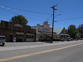
Austin is an unincorporated small town in, and former county seat of, Lander County, Nevada, United States. In 2020, the census-designated place of Austin had a population of 167. It is located on the western slopes of the Toiyabe Range at an elevation of 6,575 feet (2,004 m). U.S. Route 50 passes through the town.

Rhyolite is a ghost town in Nye County, in the U.S. state of Nevada. It is in the Bullfrog Hills, about 120 miles (190 km) northwest of Las Vegas, near the eastern boundary of Death Valley National Park.
Genoa is an unincorporated town in Douglas County, Nevada, United States. Founded in 1851, it was the first settlement in what became the Nevada Territory. It is situated within Carson River Valley and is approximately 42 miles (68 km) south of Reno. The population was 939 at the 2010 census. It is home to the oldest bar in the state of Nevada which opened in 1853.
Silver City is a ghost town in northwestern Owyhee County, Idaho, United States, that is listed on the National Register of Historic Places (NRHP). At its height in the 1880s, it was a gold and silver mining town with a population of around 2,500 and approximately 75 businesses.

Belmont is a ghost town in Nye County, Nevada, United States along former State Route 82. The town is a historic district listed in the National Register of Historic Places. It is Nevada Historical Marker number 138.

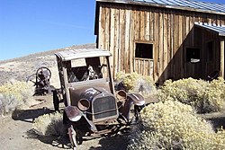
Aurora is a ghost town in Mineral County in the west central part of the US state of Nevada, approximately 22 mi (35 km) southwest of the town of Hawthorne, three miles from the California border.

Ward Charcoal Ovens State Historic Park is an area designated for historic preservation and public recreation located 20 miles (32 km) south of the town of Ely in White Pine County, Nevada. The 700-acre (280 ha) state park protects beehive-shaped charcoal ovens constructed in the latter half of the 19th century.

U.S. Route 50 (US 50) is a transcontinental highway in the United States, stretching from West Sacramento, California, in the west to Ocean City, Maryland, on the east coast. The Nevada portion crosses the center of the state and was named "The Loneliest Road in America" by Life magazine in July 1986. The name was intended as a pejorative, but Nevada officials seized it as a marketing slogan. The name originates from large desolate areas traversed by the route, with few or no signs of civilization. The highway crosses several large desert valleys separated by numerous mountain ranges towering over the valley floors, in what is known as the Basin and Range province of the Great Basin.

Leadfield was an unincorporated community, and historic mining town in Inyo County, California. It is now a ghost town. It is located in Titus Canyon in the Grapevine Mountains, east of Death Valley in Death Valley National Park. Leadfield lies at an elevation of 4,058 ft (1,237 m). It is on the National Register of Historic Places.

Garnet is a ghost town in Granite County, Montana, United States. A thriving mining town in the 1890s, Garnet's population declined when local hard rock mines closed. The remaining buildings have been preserved and are open to visitors. The site is managed by the Bureau of Land Management.
French Corral is an unincorporated community approximately five miles west of California State Highway 49 in Nevada County, California, United States.

Saint Elmo is a ghost town in Chaffee County, Colorado, United States. Founded in 1880, Saint Elmo lies in the heart of the Sawatch Range, 20 miles (32 km) southwest of Buena Vista and sits at an elevation of 9,961 feet (3,036 m). Nearly 2,000 people settled in this town when mining for gold and silver started. The mining industry started to decline in the early 1920s, and in 1922 the railroad discontinued service. The community is listed on the National Register of Historic Places as the Saint Elmo Historic District. It is one of Colorado's best preserved ghost towns.

Berlin–Ichthyosaur State Park is a public recreation area and historic preserve that protects undisturbed ichthyosaur fossils and the ghost town of Berlin in far northwestern Nye County, Nevada. The state park covers more than 1,100 acres (450 ha) at an elevation of 7,000 feet (2,100 m) on the western slope of central Nevada's Shoshone mountain range, 23 miles (37 km) east of Gabbs.

Bristol Wells, also known as National City, Bristol City and Tempest, is a ghost town in Lincoln County, Nevada. The mining town was located on the west side of Bristol Mountain, 14 miles (23 km) northwest of Pioche, Nevada.
Birchville is a historic mining and agricultural community in Nevada County, California. Birchville is located about 10 miles northwest of Nevada City and about 2 miles northeast of French Corral. It is situated at an elevation of 1,765 ft (538 m) above sea level.

Old Irontown, Old Iron Town, or Irontown, originally Iron City, is an unincorporated community and near-ghost town in Iron County, Utah, United States. It is located in Dixie National Forest, approximately 22 miles (35 km) from Cedar City. The settlement was founded in 1868 as a second attempt to mine iron from Iron Mountain after a disappointing yield from Cedar City. The colony lasted until 1876, when strife from the Edmunds–Tucker Act and the Panic of 1873 forced its closure. The site was added to the National Register of Historic Places in 1971.

Eureka Historic District is a historic district in Eureka, Nevada, United States, that is listed on the National Register of Historic Places.