
Duckwater is an American village located in the central portion of the U.S. state of Nevada, in the Duckwater Valley at about the same latitude as Sacramento, California. It is in Nye County, at the eastern edge of the Duckwater Indian Reservation, near the Red Mountain Wilderness at the end of Nevada State Route 379. The city of Las Vegas is about 200 miles to the south-southeast.

Belmont is a ghost town in Nye County, Nevada, United States along former State Route 82. The town is a historic district listed in the National Register of Historic Places. It is Nevada Historical Marker number 138.
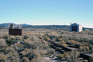
Stone House is a ghost town in Humboldt County, Nevada, United States.
Cobre is a ghost town in Elko County, Nevada, United States.
Wellington is an unincorporated town in southwestern Lyon County, Nevada, United States. It lies along State Route 208, southwest of the city of Yerington, the county seat of Lyon County. Its elevation is 4,836 feet (1,474 m). Although it is unincorporated, Wellington has a post office with the ZIP code of 89444,

Carrara is a ghost town in Nye County, Nevada. The townsite is located in the Amargosa Desert adjacent to US Route 95 about 8.5 miles southeast of Beatty. The old Tonopah and Tidewater Railroad line was about one half mile to the southwest. An old road, previously a railroad grade, runs straight for about 3 miles to the northeast up Carrara Canyon on the southeast flank of the Bare Mountains to an old marble quarry. The quarry is about 1400 feet higher in elevation than the townsite.
Potts is a ghost town and abandoned ranching property in Monitor Valley, Nye County, Nevada, approximately 2 miles east of Nevada State Route 82.

Sunnyside is a small unincorporated community in the White River Valley of eastern Nevada, near the southern terminus of the Egan Range. The site is located on State Route 318 approximately 31 miles by road south of Lund in White Pine County, the closest town, and 63 miles by road north of Hiko in Lincoln County.
Allred is a ghost town situated in Nye County, Nevada. A post office in the settlement opened on April 17, 1911 with Allen Oxborrow and George Kump as postmasters. The post office was closed more than a year later on October 31, 1912. There are no visible remains left of Allred.
Adaven is a former mining settlement and Ghost town in Nye County, Nevada.
Wahmonie was a mining town in Nevada. It was established as a gold mining camp in February 1928 and had a population of 500 by March. Peak population was reached that summer, with between 1000 and 1500 residents. Gold was not found in sufficient quantity to sustain the place, and the site was quickly abandoned. The post office was in operation from April 1928 until April 1929. Wahmonie was the last large mining rush in Nevada. The location was also known as Horn Silver Mine.
Silver Zone is an extinct town in Elko County, in the U.S. state of Nevada. The GNIS classifies it as a populated place.
White Rock is an extinct town in Elko County, in the U.S. state of Nevada.
Gilbert is an extinct town in Esmeralda County, in the U.S. state of Nevada.
Acoma is an extinct town in Lincoln County, in the U.S. state of Nevada.
Johnnie is a populated place in Nye County, in the U.S. state of Nevada about 15 miles north of Pahrump.
Lodi is an extinct town in Nye County, in the U.S. state of Nevada. The GNIS classifies it as a populated place.
Manse is an extinct town in Nye County, in the U.S. state of Nevada. The GNIS classifies it as a populated place.
Millett is an extinct town in Nye County, in the U.S. state of Nevada. The GNIS classifies it as a populated place.

Grantsville is a former town in Nye County, Nevada.

