Carrara, Nevada

Last updated
Road from Carrara, Nevada towards the marble quarry in the background. Road to Carrara, Nevada.jpg
Road from Carrara, Nevada towards the marble quarry in the background.

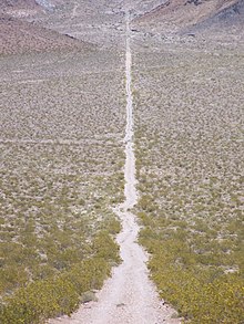
Carrara is a ghost town in Nye County, Nevada. [1] The townsite is located in the Amargosa Desert adjacent to US Route 95 about 8.5 miles southeast of Beatty. The old Tonopah and Tidewater Railroad line was about one half mile to the southwest. An old road, previously a railroad grade, runs straight for about 3 miles to the northeast up Carrara Canyon on the southeast flank of the Bare Mountains to an old marble quarry. The quarry is about 1400 feet higher in elevation than the townsite. [2]

Ghost town city depopulated of inhabitants and that stays practically intact

A ghost town is an abandoned village, town, or city, usually one that contains substantial visible remains. A town often becomes a ghost town because the economic activity that supported it has failed, or due to natural or human-caused disasters such as floods, prolonged droughts, government actions, uncontrolled lawlessness, war, pollution, or nuclear disasters. The term can sometimes refer to cities, towns, and neighbourhoods that are still populated, but significantly less so than in past years; for example, those affected by high levels of unemployment and dereliction.

Nye County, Nevada County in the United States

Nye County is a county in the U.S. state of Nevada. As of the 2010 census, the population was 43,946. Its county seat is Tonopah. At 18,159 square miles (47,030 km2), Nye is the largest county by area in the state and the third-largest county in the contiguous United States.

Nevada State of the United States of America

Nevada is a state in the Western United States. It is bordered by Oregon to the northwest, Idaho to the northeast, California to the west, Arizona to the southeast and Utah to the east. Nevada is the 7th most extensive, the 32nd most populous, but the 9th least densely populated of the U.S. states. Nearly three-quarters of Nevada's people live in Clark County, which contains the Las Vegas–Paradise metropolitan area where three of the state's four largest incorporated cities are located. Nevada's capital, however, is Carson City.

A post office was established at Carrara in 1913, and remained in operation until 1924. [3] The community was named after the Carrara marble. [4]

Carrara marble type of white or blue-grey marble popular for use in sculpture and building decor

Carrara marble is a type of white or blue-grey marble popular for use in sculpture and building decor. It is quarried in the city of Carrara located in the province of Massa and Carrara in the Lunigiana, the northernmost tip of modern-day Tuscany, Italy.

Related Research Articles

Au Train Township, Michigan Civil township in Michigan, United States

Au Train Township is a civil township of Alger County in the U.S. state of Michigan. As of the 2010 census, the township population was 1,138.

Munising Township, Michigan Civil township in Michigan, United States

Munising Township is a civil township of Alger County in the U.S. state of Michigan. As of the 2010 census, the township population was 2,983.

Volinia Township, Michigan Civil township in Michigan, United States

Volinia Township is a civil township of Cass County in the U.S. state of Michigan. The population was 1,112 at the 2010 census. When the township was organized in 1833, it was at first named Volhynia, after the province in Poland. It is believed to have been given to honor General Tadeusz Kościuszko, the Polish patriot who helped the United States during the American Revolutionary War. The name was altered first to "Volenia" and then by 1901 or earlier to "Volinia".

Powell Township, Michigan Civil township in Michigan, United States

Powell Township is a civil township of Marquette County in the U.S. state of Michigan. The population was 724 at the 2000 census.

Oak Grove, Oregon Census-designated place in Oregon, United States

Oak Grove is an unincorporated community in Clackamas County, Oregon, United States, in the Portland metropolitan area. For statistical purposes, the United States Census Bureau has defined Oak Grove as a census-designated place (CDP). The census definition of the area may not precisely correspond to local understanding of the area with the same name. The population was 16,629 at the 2010 census.

Contact, Nevada Unincorporated community in Nevada, United States

Contact is an unincorporated community in Elko County, Nevada, United States. It is located on a mineral-rich granite intrusion and there are many mines nearby.

Ogilby, California Ghost town in California, United States

Ogilby is a ghost town in Imperial County, California, United States. Ogilby is located on the Southern Pacific Railroad 42 miles (68 km) east of El Centro, and 3.8 miles (6.1 km) north of Interstate 8 on County Road S34. The name is official for federal use, and a feature ID number of 252950 has been assigned. Ogilby is defined by the US Geological Survey as a populated place at 356 feet (109 m) AMSL elevation. NAD27 latitude and longitude are listed at 32°49′01″N114°50′20″W on the "Ogilby, California" 7.5-minute quadrangle (map). It is included in the Imperial County Air Pollution Control District. It lies at an elevation of 364 feet (111 m).

Ivanpah (ghost town), California Ghost town in California, United States

Ivanpah was a short-lived silver mining town located in San Bernardino County, California, United States. It was founded in 1869 and existed until at least the mid-1880s.

Bare Mountain Range (Nevada)

The Bare Mountain Range is a mountain range in southern Nye County, Nevada, in the United States. Bare Mountain and Wildcat Peak are the high points of the range.

Biola Junction, California Unincorporated community in California, United States

Biola Junction is an unincorporated community in Fresno County, California. It is located on the Southern Pacific Railroad 5.5 miles (9 km) west-northwest of Fresno, at an elevation of 299 feet.

Nolin, Oregon Unincorporated community in Oregon, United States

Nolin is an unincorporated community in Umatilla County, Oregon, United States. Nolin is about 8 miles (13 km) southeast of Echo, next to the Umatilla River. At one time the area was known as "Happy Canyon". Adam "Ad" W. Nye, a settler of the 1860s, named the Nolin area Happy Canyon, for the spirit of the people who lived there. The name was later adopted by Pendleton Round-Up for its indoor show in commemoration of this time. Nye was County Sheriff in 1872–74. The nearby community of Nye was named for him.

Hazen, Nevada Churchill County, Nevada, USA

Hazen is an unincorporated community in Churchill County, Nevada, United States, about 12 miles (19 km) southeast of Fernley and 16 miles (26 km) northwest of Fallon, on U.S. Route 50 Alternate.

Fairlawn is a ghost town in Elko County, in the U.S. state of Nevada.

Avon is an unincorporated community in Latah County, in the U.S. state of Idaho.

Helmer is an unincorporated community in Latah County, in the U.S. state of Idaho.

Phenix, Missouri unincorporated community in Missouri

Phenix is an unincorporated community in northwest Greene County, in the U.S. state of Missouri. The community is located on the banks of Sugar Creek, approximately 2.5 miles south of Walnut Grove and 1.5 miles west of Harold and Missouri Route 123.

Nance is an extinct town in eastern Taney County, in the Ozarks of southwest Missouri. The GNIS classifies it as a populated place. The townsite sits above the east bank of the west fork of Big Creek about one mile north of U.S. Route 160 and about 1.7 miles west of the Taney - Ozark county line. The site is at an elevation of 876 feet.

Blair Junction, Nevada Ghost town

Blair Junction is the neglected site of a formerly populated settlement in Esmeralda County, in the U.S. state of Nevada.

National is an extinct town in Humboldt County, in the U.S. state of Nevada.

Johnnie is an extinct town in Nye County, in the U.S. state of Nevada. The GNIS classifies it as a populated place.

References

Coordinates: 36°48′03″N116°42′44″W / 36.80083°N 116.71222°W / 36.80083; -116.71222

Geographic coordinate system Coordinate system

A geographic coordinate system is a coordinate system that enables every location on Earth to be specified by a set of numbers, letters or symbols. The coordinates are often chosen such that one of the numbers represents a vertical position and two or three of the numbers represent a horizontal position; alternatively, a geographic position may be expressed in a combined three-dimensional Cartesian vector. A common choice of coordinates is latitude, longitude and elevation. To specify a location on a plane requires a map projection.