Springdale, Nevada

Last updated
Springdale, Nevada, ca. 1912 Springdale, Nevada ca. 1912.JPG
Springdale, Nevada, ca. 1912

Springdale is a privately owned ghost town in Nevada, United States. It is inaccessible to the general public.

Ghost town City depopulated of inhabitants and that stays practically intact

A ghost town is an abandoned village, town, or city, usually one that contains substantial visible remains. A town often becomes a ghost town because the economic activity that supported it has failed, or due to natural or human-caused disasters such as floods, prolonged droughts, government actions, uncontrolled lawlessness, war, pollution, or nuclear disasters. The term can sometimes refer to cities, towns, and neighbourhoods that are still populated, but significantly less so than in past years; for example, those affected by high levels of unemployment and dereliction.

Nevada U.S. state in the United States

Nevada is a state in the Western United States. It is bordered by Oregon to the northwest, Idaho to the northeast, California to the west, Arizona to the southeast, and Utah to the east. Nevada is the 7th most extensive, the 32nd most populous, but the 9th least densely populated of the U.S. states. Nearly three-quarters of Nevada's people live in Clark County, which contains the Las Vegas–Paradise metropolitan area where three of the state's four largest incorporated cities are located. Nevada's capital is Carson City.

Location

Topographic map of Bullfrog Goldfield Railroad 1908 north of Bullfrog Bullfrog Goldfield Railroad 1908 north of Bullfrog.jpg
Topographic map of Bullfrog Goldfield Railroad 1908 north of Bullfrog

Springdale lies in Nye County, along the Amargosa River at a crossroad of U.S. Route 95 between Las Vegas and Reno.

Nye County, Nevada County in the United States

Nye County is a county in the U.S. state of Nevada. As of the 2010 census, the population was 43,946. Its county seat is Tonopah. At 18,159 square miles (47,030 km2), Nye is the largest county by area in the state and the third-largest county in the contiguous United States.

Amargosa River intermittent waterway in southern Nevada and eastern California

The Amargosa River is an intermittent waterway, 185 miles (298 km) long, in southern Nevada and eastern California in the United States. It drains a high desert region, the Amargosa Valley in the Amargosa Desert northwest of Las Vegas, into the Mojave Desert, and finally into Death Valley where it disappears into the ground aquifer. Except for a small portion of its route in the Amargosa Canyon in California and a small portion at Beatty, Nevada, the river flows above ground only after a rare rainstorm washes the region. A 26-mile (42 km) stretch of the river between Shoshone and Dumont Dunes is protected as a National Wild and Scenic River. At the south end of Tecopa Valley the Amargosa River Natural Area protects the habitat.

U.S. Route 95 in Nevada highway in Nevada

U.S. Route 95 is a major U.S. highway traversing the U.S. state of Nevada from north to south directly through Las Vegas and providing connections to both Carson City and Reno. US 95 is cosigned with Interstate 80 for 95 miles (153 km) between a junction in Trinity and Winnemucca before heading north into Oregon at McDermitt.

The first settlers in the area were Native American Indians. When the first Europeans arrived in the late 1800s, six ranches were built along the Bonanza Trail, making use of the valley's fertile soil. Three were owned by George Davies, Ed Giles and "Panamint Joe" Stuart [1] of the Indian Joe Ranch, which was sold to A. J. Lidwell. One ranch was called Windmill Ranch. [2] [3]

Native Americans in the United States Indigenous peoples of the United States (except Hawaii)

Native Americans, also known as American Indians, Indigenous Americans and other terms, are the indigenous peoples of the United States, except Hawaii and territories of the United States. More than 570 federally recognized tribes live within the US, about half of which are associated with Indian reservations. The term "American Indian" excludes Native Hawaiians and some Alaskan Natives, while "Native Americans" are American Indians, plus Alaska Natives of all ethnicities. The US Census does not include Native Hawaiians or Chamorro, instead being included in the Census grouping of "Native Hawaiian and other Pacific Islander".

Albert J. "Lucky" Lidwell set up a town around the old Indian Joe Ranch in July 1906. A station of the Bullfrog Goldfield Railroad was opened in May 1907, which was also used by the Tonopah and Tidewater Railroad since 1908. The area was rich in both firewood and water, which were both needed to run steam locomotives. In 1907, the town got its own post office, of course with Lucky Lidwell as postmaster. By that time the town had four saloons, several restaurants, a school, a depot, a sawmill. A fifty-ton mill was used to process ores from the surrounding mines, a Gilds Mall, a hotel, a livery stable provided employment to many workers, who were served by 14 illicit prostitutes in the increasingly attractive red light area. [2]

Bullfrog Goldfield Railroad

The Bullfrog Goldfield Railroad (BGRR) was a former Class II railroad lying just inside and about midway of the southwestern State line of Nevada. It was incorporated in 1905 to provide an outlet from the mining section near Beatty to the north over the lines of the Tonopah and Goldfield Railroad and the Southern Pacific Railroad.

Tonopah and Tidewater Railroad

The Tonopah and Tidewater Railroad was a former class II railroad that ran within the locale of eastern California and southwestern Nevada.

Prostitution Engaging in sexual relations in exchange for payment

Prostitution is the business or practice of engaging in sexual activity in exchange for payment. Prostitution is sometimes described as sexual services, commercial sex or, colloquially, hooking. It is sometimes referred to euphemistically as "the world's oldest profession" in the English-speaking world. A person who works in this field is called a prostitute, and is a type of sex worker.

The Springdale Water & Power Co. began on 7 April 1909 to supply electricity to the town, which had 293 inhabitants in 1910. Springdale was very popular, but its attractiveness declined when the ore mill closed down in 1911. The post office was subsequently relocated to Pioneer on 15 January 1912. The railroad stopped operating in 1928, and the depot was dismantled and relocated to Las Vegas for another use. [2]

Pioneer, Nevada Ghost town in Nevada, United States

Pioneer is a ghost town in Nye County, in the U.S. state of Nevada. Beginning as a mining camp near the Mayflower and other gold mines in northern Bullfrog Hills, it became a formal town in 1908 and flourished briefly until fire destroyed much of its business district in 1909 and litigation delayed mining. Population peaked at an estimated 2,500 in 1908, and the community survived at least through the closing of the Pioneer post office in 1931. Mining continued near the town site through 1941. Few remnants of Pioneer structures survived through the end of the 20th century.

Due to the increasing popularity of private cars, U.S. Route 95 was built, along which a Union Oil gas station, one or two repair shops and a junkyard offered their services to motorists. Springdale was just outside of the Air Force's military ranges, where bomber pilots were trained for their service in World War II. [2] Use of extensive areas as bombing ranges limited the nearby population that the town had served.

As of 2017 some of the old buildings still exist. The properties in and around Springdale are owned by a half-dozen locals and are inhabited by four families. [2]

Related Research Articles

Dewey–Humboldt, Arizona Town in Arizona, United States

Dewey–Humboldt is a town in Yavapai County, Arizona, United States. The population of the town was 3,894 according to the 2010 census. The Dewey–Humboldt area was a census-designated place (CDP) at the 2000 census, at which time its population was 6,295.

Indian Springs, Nevada Unincorporated town in Nevada, United States

Indian Springs is an unincorporated town and a census-designated place near Creech Air Force Base in northwestern Clark County, southwestern Nevada.

Beatty, Nevada Unincorporated town in Nevada, United States

Beatty is an unincorporated town along the Amargosa River in Nye County in the U.S. state of Nevada. U.S. Route 95 runs through the town, which lies between Tonopah, about 90 miles (140 km) to the north, and Las Vegas, about 120 miles (190 km) to the southeast. State Route 374 connects Beatty to Death Valley National Park, about 8 miles (13 km) to the west.

Tonopah, Nevada Unincorporated town in Nevada, United States

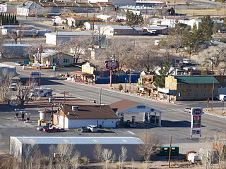
Tonopah is an unincorporated town in and the county seat of Nye County, Nevada, United States. It is located at the junction of U.S. Routes 6 and 95, approximately midway between Las Vegas and Reno. In the 2010 census, the population was 2,478. The census-designated place (CDP) of Tonopah has a total area of 16.2 square miles (42 km2), all land.

Rhyolite, Nevada Ghost town in Nevada, United States

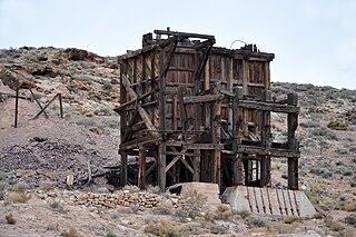
Rhyolite is a ghost town in Nye County, in the U.S. state of Nevada. It is in the Bullfrog Hills, about 120 miles (190 km) northwest of Las Vegas, near the eastern edge of Death Valley. The town began in early 1905 as one of several mining camps that sprang up after a prospecting discovery in the surrounding hills. During an ensuing gold rush, thousands of gold-seekers, developers, miners and service providers flocked to the Bullfrog Mining District. Many settled in Rhyolite, which lay in a sheltered desert basin near the region's biggest producer, the Montgomery Shoshone Mine.

This history of Las Vegas covers both the city of Las Vegas, Nevada and the Las Vegas Valley.

Scottys Junction, Nevada town

Scotty's Junction is an unincorporated community in the Sarcobatus Flat of Nye County, Nevada where State Route 267 meets with U.S. Route 95 at an elevation of 4,062 feet (1,238 m).

Nelson, Nevada Census-designated place in Nevada, United States

Nelson is a census-designated place in Clark County, Nevada, United States. The community is in the Pacific Standard Time zone. The location of Nelson is in El Dorado Canyon, Eldorado Mountains. The town is in the southeast region of the Eldorado Valley. As of the 2010 census it had a population of 37.

Delamar, Nevada Ghost town in Nevada, United States

Delamar, Nevada, nicknamed The Widowmaker, is a ghost town in central eastern Nevada, USA along the east side of the Delamar Valley. During its heyday, primarily between 1895 and 1900, it produced $13.5 million in gold.

Gold Center, Nevada human settlement in Nevada, United States of America

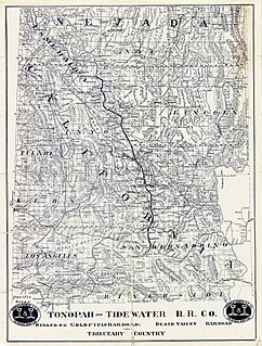
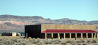
Gold Center was a mining town in Nye County, Nevada. Located in the Bullfrog Mining District south of Tonopah, Gold Center was established in December 1904 with a United States Post Office being authorized on January 21, 1905. The town began publishing its own newspaper in 1907. The location of the town was ideal as it was on the stagecoach route to Rhyolite and Beatty. It was also near the Amargosa River, allowing sufficient water for drinking and for two mills and an ice house. Gold Center also sold water to Rhyolite and Carrara. The Tonopah and Tidewater Railroad, the Las Vegas & Tonopah Railroad and the Bullfrog Goldfield Railroad all ran through Gold Center. Gold Center also had the first brewery in the area which was built underground to maintain a cool temperature.

Blair, Nevada Ghost town in Nevada, United States

Blair, Nevada is a mining ghost town in Esmeralda County, Nevada.

History of Nevada history of the US state of Nevada

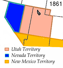
Nevada became the 36th state on October 31, 1864, after telegraphing the Constitution of Nevada to the Congress days before the November 8 presidential election. Statehood was rushed to help ensure three electoral votes for Abraham Lincoln's reelection and add to the Republican congressional majorities.

Las Vegas and Tonopah Railroad

The Las Vegas and Tonopah Railroad was a 197.9 mile railroad built by William A. Clark that ran northwest from a connection with the mainline of the San Pedro, Los Angeles and Salt Lake Railroad at Las Vegas, Nevada to the gold mines at Goldfield. The SPLA&SL railroad later became part of the Union Pacific Railroad and serves as their mainline between Los Angeles and Salt Lake City.

Tropicana Laughlin

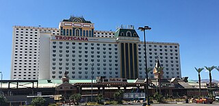
The Tropicana Laughlin is a hotel and casino in Laughlin, Nevada. It is owned by Gaming and Leisure Properties and operated by Eldorado Resorts. The hotel has 1,498 guest rooms and suites, located in the 12-story Casino Tower and the 24-story Promenade Tower. The casino has 1,050 slot machines and 21 table games. It includes the restaurants: The Steakhouse, Passaggio Italian Gardens, Carnegie's Café, Taqueria Del Rio, Poolside Café, Dips & Dogs and Victory Plaza.

Bonnie Springs Ranch

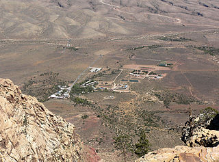
Bonnie Springs Ranch was an attraction near Blue Diamond, Nevada that included an 1880s western town replica and a zoo. It is located on 63.86 acres (25.84 ha) in the Mojave Desert, below the Spring Mountains in the Red Rock Canyon area, 20 miles west of Las Vegas. The ranch has natural oasis habitat, from the spring water surfacing there.

Pyramid, Nevada Unincorporated community in Nevada, United States

Pyramid is an unincorporated community in Washoe County, Nevada, United States. At one time, it was a station on the Fernley and Lassen Railway located between Bristol and Big Canyon. At one time there was a post office at this location.

Veteran, Nevada Ghost town in Nevada, United States

Veteran is a ghost town in the state of Nevada. Located just west of the current town of Ruth, Veteran was the site of a tent city and mining town between 1906 and 1914, though the current site is abandoned.

T&T Ranch

The T&T Ranch was a demonstration farm and dairy, that was situated in the Amargosa Valley, 5.5 miles southeast of Leeland in Nye County, Nevada. It was owned by the Tonopah and Tidewater Railroad between its foundation in 1915 and the 1940s. During that time five pieces of land were added to the property, that were obtained under the Pittman Underground Water Act. The T&T Ranch was thereafter occupied by Gordon and Billie Bettles.

References

  1. Stoffle, Richard W.; Olmsted, John E.; Evans, Michael J. (Jan 1990). Literature Review and Ethnohistory of Native American Occupancy and Use of the Yucca Mountain Region (PDF). Las Vegas, Nevada: Science Applications International Corporation. p. 33. Retrieved 25 April 2017.
  2. 1 2 3 4 5 jb. "Ghost Town, Springdale Nevada". frias.net. Retrieved 2017-04-21.
  3. "Springdale - Nevada Ghost Town". ghosttowns.com. Retrieved 2017-04-21.

Coordinates: 37°01′48″N116°45′19″W / 37.030108°N 116.755401°W / 37.030108; -116.755401