
Nye County is a county in the U.S. state of Nevada. As of the 2020 census, the population was 51,591. Its county seat is Tonopah. At 18,159 square miles (47,030 km2), Nye is Nevada's largest county by area and the third-largest county in the contiguous United States, behind Coconino County of Arizona and San Bernardino County of California.
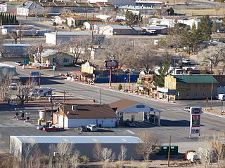
Beatty is an unincorporated town along the Amargosa River in Nye County, Nevada, United States. U.S. Route 95 runs through the town, which lies between Tonopah, about 90 miles (140 km) to the north and Las Vegas, about 120 miles (190 km) to the southeast. State Route 374 connects Beatty to Death Valley National Park, about 8 miles (13 km) to the west.

Amargosa Valley is an unincorporated town located on U.S. Route 95 in Nye County, in the U.S. state of Nevada.

Rhyolite is a ghost town in Nye County, in the U.S. state of Nevada. It is in the Bullfrog Hills, about 120 miles (190 km) northwest of Las Vegas, near the eastern boundary of Death Valley National Park.

The Tonopah and Tidewater Railroad was a former class II railroad that served eastern California and southwestern Nevada.

The Amargosa Desert is located in Nye County in western Nevada, United States, along the California–Nevada border, comprising the northeastern portion of the geographic Amargosa Valley, north of the Ash Meadows National Wildlife Refuge.
Ludlow is an unincorporated community in the Mojave Desert on Interstate 40, located in San Bernardino County, California, United States. The older remains of the ghost town are along historic Route 66.
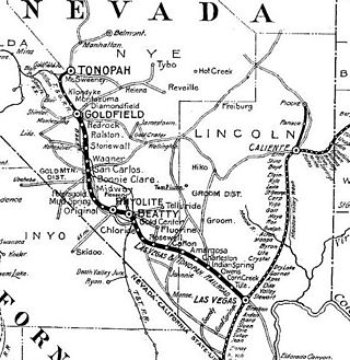
The Las Vegas and Tonopah Railroad was a 197.9-mile (318.5 km) railroad built by William A. Clark that ran northwest from a connection with the mainline of the San Pedro, Los Angeles, and Salt Lake Railroad at Las Vegas, Nevada to the gold mines at Goldfield. The SPLA&SL railroad later became part of the Union Pacific Railroad and serves as their mainline between Los Angeles and Salt Lake City.

The Keane Wonder Mine and mill is an abandoned mining facility located within Death Valley National Park in Inyo County, California. It is located in the Funeral Mountains east of Death Valley and Furnace Creek, California

The Bullfrog Hills are a small mountain range of the Mojave Desert in southern Nye County, southwestern Nevada. Bullfrog Hills was so named from a fancied resemblance of its ore to the color of a bullfrog.

Bullfrog is a ghost town in Nye County, in the U.S. state of Nevada. It is located at the north end of the Amargosa Desert about 4 miles (6.4 km) west of Beatty. Less than 1 mile (1.6 km) north of Bullfrog are the Bullfrog Hills and the ghost town of Rhyolite. The two ghost towns are about 120 miles (190 km) northwest of Las Vegas, 60 miles (97 km) south of Goldfield, and 90 miles (140 km) south of Tonopah.

Carrara is a ghost town in Nye County, Nevada. The townsite is located in the Amargosa Desert adjacent to US Route 95 about 8.5 miles southeast of Beatty. The old Tonopah and Tidewater Railroad line was about one half mile to the southwest. An old road, previously a railroad grade, runs straight for about 3 miles to the northeast up Carrara Canyon on the southeast flank of the Bare Mountains to an old marble quarry. The quarry is about 1400 feet higher in elevation than the townsite.
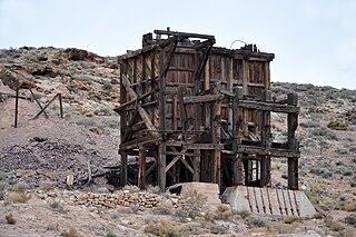
Pioneer is a ghost town in Nye County, in the U.S. state of Nevada. Beginning as a mining camp near the Mayflower and other gold mines in northern Bullfrog Hills, it became a formal town in 1908 and flourished briefly until fire destroyed much of its business district in 1909 and litigation delayed mining. Population peaked at an estimated 2,500 in 1908, and the community survived at least through the closing of the Pioneer post office in 1931. Mining continued near the town site through 1941. Few remnants of Pioneer structures survived through the end of the 20th century.

The Tonopah and Goldfield Railroad, a railroad of 100.4 miles (161.6 km) in length in the U.S. state of Nevada, offered point-to-point service between Mina and Goldfield, running over the Excelsior Mountains and parallel to the Monte Cristo Range. It operated from 1905 until 1947.
Hot Springs is located in Nye County, just north of Beatty, Nevada. In the early 1900s, the Las Vegas & Tonopah Railroad Company and the Bullfrog Goldfield Railroad stopped at a station in Hot Springs.
Leeland is a former railway hamlet in the Amargosa Valley in Nye County, Nevada. A year after its founding in 1906, a railway station was opened. Raw materials from the nearby Californian mining village Lee were brought to Leeland to be transported by train.

The T&T Ranch was a demonstration farm and dairy, that was situated in the Amargosa Valley, 5.5 miles southeast of Leeland in Nye County, Nevada. It was owned by the Tonopah and Tidewater Railroad between its foundation in 1915 and the 1940s. During that time five pieces of land were added to the property, that were obtained under the Pittman Underground Water Act. The T&T Ranch was thereafter occupied by Gordon and Billie Bettles.

The Bullfrog Goldfield Railroad (BGRR) was a railroad lying just inside and about midway of the southwestern State line of Nevada. It was incorporated in 1905 to provide an outlet from the mining section near Beatty to the north over the lines of the Tonopah and Goldfield Railroad and the Southern Pacific Railroad.

Springdale is a privately owned ghost town in Nevada, United States. It is inaccessible to the general public.

Beatty Museum, also known as Beatty Museum and Historical Society, is a volunteer-run local history museum in Beatty, Nevada that showcases the history of the Bullfrog mining district, including its townspeople and their way of life. The museum was founded in 1995 and has experienced several changes in location since its founding.

