Pioneer, Nevada

Last updated
Pioneer, Nevada
Pioneer (ghost town) ruins.jpg
Ruins at Pioneer, Nevada, a former mining town
USA Nevada location map.svg
Red pog.svg
Pioneer, Nevada
Coordinates: 37°00′19″N116°47′02″W / 37.00528°N 116.78389°W / 37.00528; -116.78389 [1]
CountryUnited States
StateNevada
County Nye
Elevation
[1]
4,222 ft (1,287 m)
Population
 (1908)
  Total~2,500
Time zone UTC-8 (Pacific (PST))
  Summer (DST)PDT (UTC-7)

Pioneer is a ghost town in Nye County, in the U.S. state of Nevada. Beginning as a mining camp near the Mayflower and other gold mines in northern Bullfrog Hills, it became a formal town in 1908 and flourished briefly until fire destroyed much of its business district in 1909 and litigation delayed mining. Population peaked at an estimated 2,500 in 1908, and the community survived at least through the closing of the Pioneer post office in 1931. Mining continued near the town site through 1941. Few remnants of Pioneer structures survived through the end of the 20th century.

Contents

Geography

Pioneer is on the north side of the Bullfrog Hills along Pioneer Road, a gravel road off U.S. Route 95. It is about 7 miles (11 km) north of Beatty, 8 miles (13 km) northeast of the ghost towns of Rhyolite and Bullfrog, and 130 miles (210 km) northwest of Las Vegas. Desert springs in or near the Oasis Valley of the Amargosa River are 2 to 4 miles (3.2 to 6.4 km) east of Pioneer. Donovan Mountain in the Bullfrog Hills rises to 5,597 feet (1,706 m) above sea level near Sarcobatus Flat slightly west of the ghost town, and the northeastern corner of Death Valley National Park is about 3 miles (4.8 km) further west. [2] [3]

History

Pioneer developed from a primitive mining camp near the Mayflower, Pioneer, and other gold mines on the north side of the Bullfrog Hills. These mines were part of the Bullfrog Mining District, which included mines on the south side of the hills in places like Rhyolite and Bullfrog. Industrialist Charles M. Schwab, who invested heavily in the Montgomery-Shoshone Mine near Rhyolite, also invested in the Mayflower in 1906. A Pioneer town-site company was formed in 1908 and began grading roads and selling lots. In that year, a daily stagecoach began making runs between Pioneer and the mining town of Springdale, about 2 miles (3.2 km) to the northeast along the Bullfrog Goldfield Railroad. Another daily stagecoach linked Pioneer and Rhyolite in 1909 along a road constructed for the purpose. [4]

As the mines near Rhyolite declined late in the decade, some miners and businesses moved to Pioneer and in some cases took their buildings with them. A group of investors from Rhyolite and Tonopah bought the Montgomery Hotel in Beatty and moved it to Pioneer in February 1909, renaming it the Holland House, "the grandest building Pioneer would ever have". [5] Later that spring, Pioneer's population had grown to an estimated 2,500 occupying an estimated 300 buildings. [6] They included the town's post office, which the federal government approved in March 1909. [4] In addition to the stagecoach, early automobiles ferried people back and forth between Pioneer and the Las Vegas and Tonopah Railroad station in Rhyolite.

Water was available by the barrel from Springdale and Crystal Springs, 3 miles (4.8 km) to the southeast. For about five months in 1909, the town had two weekly newspapers, the Pioneer Topics and the Pioneer Press. [4] Businesses in Pioneer included a drug store, a doctor's office, a barber shop, eating establishments, a liquor store, saloons, a meat market, a general store, a bank, and boarding houses, in addition to the Holland House. Just after the town reached its peak of development in March and April 1909, [5] a May 9 fire destroyed much of the business district, [7] and, although the town continued to prosper for a while, "the excitement would never be the same". [8]

The town rebuilt the business district and opened a school enrolling 44 students in mid-1909. [9] Several mines with steady payrolls sustained Pioneer through the end of the year, but litigation slowed work at the Mayflower and other nearby mines, and the town's growth ceased. Fall enrollment at the school dropped to 24, [9] and residents held a "Hard Times Dance" at the Holland Hotel at the beginning of 1910. [10] Disputes about mine ownership led to further litigation, and the failure of the First National Bank of Rhyolite hampered investments in Pioneer. Stores began to close, and in August 1910, the Holland Hotel was sold to pay delinquent taxes. [10] A shrinking population lived in or near Pioneer for many years, and the post office stayed open through early 1931. [10] Mining, continuing in the area through the 1930s, was suspended in 1941, and did not resume on a large scale after World War II. [10] As of 2004, little remained of Pioneer aside from "quite a bit of debris, levelled building sites, a few boards, and perhaps some foundations" [11] and, nearby, remnants of the Mayflower headframe and ore bin.

Related Research Articles

<span class="mw-page-title-main">Nye County, Nevada</span> County in Nevada, United States

Nye County is a county in the U.S. state of Nevada. As of the 2020 census, the population was 51,591. Its county seat is Tonopah. At 18,159 square miles (47,030 km2), Nye is Nevada's largest county by area and the third-largest county in the contiguous United States, behind Coconino County of Arizona and San Bernardino County of California.

<span class="mw-page-title-main">Beatty, Nevada</span> Unincorporated town in Nevada, United States

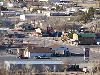
Beatty is an unincorporated town along the Amargosa River in Nye County in the U.S. state of Nevada. U.S. Route 95 runs through the town, which lies between Tonopah, about 90 miles (140 km) to the north and Las Vegas, about 120 miles (190 km) to the southeast. State Route 374 connects Beatty to Death Valley National Park, about 8 miles (13 km) to the west.

<span class="mw-page-title-main">Tonopah, Nevada</span> Unincorporated town in the State of Nevada, United States

Tonopah is an unincorporated town in, and the county seat of, Nye County, Nevada, United States. Nicknamed the Queen of the Silver Camps for its mining-rich history, it is now primarily a tourism-based resort city, notable for attractions like the Mizpah Hotel and the Clown Motel.

<span class="mw-page-title-main">Rhyolite, Nevada</span> Ghost town in Nevada, United States

Rhyolite is a ghost town in Nye County, in the U.S. state of Nevada. It is in the Bullfrog Hills, about 120 miles (190 km) northwest of Las Vegas, near the eastern boundary of Death Valley National Park. The town began in early 1905 as one of several mining camps that sprang up after a prospecting discovery in the surrounding hills. During an ensuing gold rush, thousands of gold-seekers, developers, miners and service providers flocked to the Bullfrog Mining District. Many settled in Rhyolite, which lay in a sheltered desert basin near the region's biggest producer, the Montgomery Shoshone Mine.

<span class="mw-page-title-main">Tonopah and Tidewater Railroad</span>

The Tonopah and Tidewater Railroad was a former class II railroad that served eastern California and southwestern Nevada.

<span class="mw-page-title-main">Gold Point, Nevada</span> Ghost town in Nevada, United States

Gold Point, Nevada is a well-preserved historic mining town in Esmeralda County, Nevada. The community was named after the local gold-mining industry. Gold Point is the southern terminus of Nevada State Route 774. Its current population is about seven.

Ludlow is an unincorporated community in the Mojave Desert on Interstate 40, located in San Bernardino County, California, United States. The older remains of the ghost town are along historic Route 66.

<span class="mw-page-title-main">Gold Center, Nevada</span> Ghost town in Nevada, US

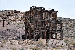
Gold Center was a mining town in Nye County, Nevada. Located in the Bullfrog Mining District south of Tonopah, Gold Center was established in December 1904 with a United States Post Office being authorized on January 21, 1905. The town began publishing its own newspaper in 1907. The location of the town was ideal as it was on the stagecoach route to Rhyolite and Beatty. It was also near the Amargosa River, allowing sufficient water for drinking and for two mills and an ice house. Gold Center also sold water to Rhyolite and Carrara. The Tonopah and Tidewater Railroad, the Las Vegas & Tonopah Railroad and the Bullfrog Goldfield Railroad all ran through Gold Center. Gold Center also had the first brewery in the area which was built underground to maintain a cool temperature.

<span class="mw-page-title-main">Rawhide, Nevada</span> Mining settlement, now ghost town

Rawhide, Nevada was a town in Mineral County, Nevada, approximately 55 miles southeast of Fallon. The site of Rawhide has been dismantled by recent mining activity, with little or nothing remaining to be seen.

<span class="mw-page-title-main">Las Vegas and Tonopah Railroad</span>

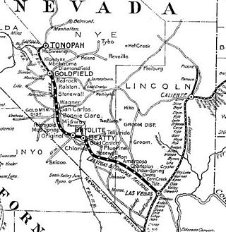
The Las Vegas and Tonopah Railroad was a 197.9-mile (318.5 km) railroad built by William A. Clark that ran northwest from a connection with the mainline of the San Pedro, Los Angeles and Salt Lake Railroad at Las Vegas, Nevada to the gold mines at Goldfield. The SPLA&SL railroad later became part of the Union Pacific Railroad and serves as their mainline between Los Angeles and Salt Lake City.

<span class="mw-page-title-main">Bullfrog Hills</span> Mountain range in Nevada, United States

The Bullfrog Hills are a small mountain range of the Mojave Desert in southern Nye County, southwestern Nevada. Bullfrog Hills was so named from a fancied resemblance of its ore to the color of a bullfrog.

<span class="mw-page-title-main">Goldwell Open Air Museum</span> Sculpture park and artist residency program

The Goldwell Open Air Museum is an outdoor sculpture park near the ghost town of Rhyolite in the U.S. state of Nevada. The 7.8-acre (3.2 ha) site is located at the northern end of the Amargosa Valley, about 120 miles (190 km) northwest of Las Vegas, and about 4 miles (6.4 km) west of Beatty off State Route 374. About 5 miles (8.0 km) further west is Death Valley National Park. In addition to the museum, the site includes the Red Barn Art Center, a 2,250-square-foot (209 m2) multi-purpose studio and exhibition space used by artists-in-residence and other artists. Near the art center are the ruins of a jail and other buildings of the historic mining town of Bullfrog.

<span class="mw-page-title-main">Berlin Historic District (Berlin, Nevada)</span> Historic district in Nevada, United States

The Berlin Historic District encompasses the ghost town of Berlin in Nye County, Nevada. The town was established in 1897 as part of the Union Mining District after the opening of the Berlin Mine the previous year. The name is a transfer from Berlin, in Germany, the native land of a share of the local prospectors. The town never prospered to the same extent as other boom towns like Tonopah and Goldfield, and declined following the Panic of 1907. The town was largely abandoned by 1911. The site was acquired by the state of Nevada as part of Berlin–Ichthyosaur State Park in 1970.

<span class="mw-page-title-main">Bullfrog, Nevada</span> Ghost town in Nevada, United States

Bullfrog is a ghost town in Nye County, in the U.S. state of Nevada. It is located at the north end of the Amargosa Desert about 4 miles (6.4 km) west of Beatty. Less than 1 mile (1.6 km) north of Bullfrog are the Bullfrog Hills and the ghost town of Rhyolite. The two ghost towns are about 120 miles (190 km) northwest of Las Vegas, 60 miles (97 km) south of Goldfield, and 90 miles (140 km) south of Tonopah.

<i>The Air Mail</i> 1925 film by Irvin Willat

The Air Mail is a 1925 American silent drama film directed by Irvin Willat and starring Warner Baxter, Billie Dove, and Douglas Fairbanks, Jr. It was produced by Famous Players–Lasky and distributed through Paramount Pictures. Filmed in Death Valley National Park and the ghost town of Rhyolite, Nevada, it was released in the United States on March 16, 1925.

<span class="mw-page-title-main">Tonopah and Goldfield Railroad</span>

The Tonopah and Goldfield Railroad, a railroad of 100.4 miles (161.6 km) in length in the U.S. state of Nevada, offered point-to-point service between Mina and Goldfield, running over the Excelsior Mountains and parallel to the Monte Cristo Range. It operated from 1905 until 1947.

Hot Springs is located in Nye County, just north of Beatty, Nevada. In the early 1900s, the Las Vegas & Tonopah Railroad Company and the Bullfrog Goldfield Railroad stopped at a station in Hot Springs.

<span class="mw-page-title-main">Bullfrog Goldfield Railroad</span>

The Bullfrog Goldfield Railroad (BGRR) was a railroad lying just inside and about midway of the southwestern State line of Nevada. It was incorporated in 1905 to provide an outlet from the mining section near Beatty to the north over the lines of the Tonopah and Goldfield Railroad and the Southern Pacific Railroad.

<span class="mw-page-title-main">Springdale, Nevada</span>

Springdale is a privately owned ghost town in Nevada, United States. It is inaccessible to the general public.

George Graham Rice was a convicted stock swindler. He was known as the "Jackal of Wall Street."

References

  1. 1 2 "Pioneer (locale)". Geographic Names Information System (GNIS). United States Geological Survey. December 12, 1980. Retrieved November 16, 2009.
  2. Nevada Road & Recreation Atlas (Map) (2007 ed.). Benchmark Maps. § 78. ISBN   978-0-929591-95-7.
  3. The Road Atlas (Map) (2008 ed.). Rand McNally & Company. § 64. ISBN   0-528-93961-0.
  4. 1 2 3 Patera, Alan H. (2004). "Rhyolite's Demise and the Rise and Fall of Pioneer and Springdale". Western Places. Lake Grove, Oregon. 7 (4): 11–20. ISSN   1092-8782.
  5. 1 2 Patera, p. 15
  6. Patera, pp. 1516, citing Pioneer townsite agent J.W. Conlisk and an article in the Rhyolite Bullfrog Miner
  7. Patera, pp. 1920
  8. Patera, p.20
  9. 1 2 Patera, pp. 2528
  10. 1 2 3 4 Patera, pp. 5557
  11. Patera, p. 57