Gatecliff Rockshelter

Last updated

Gatecliff Rockshelter
Gatecliff Rockshelter 1974-1.jpg
USA Nevada location map.svg
Red pog.svg
Usa edcp location map.svg
Red pog.svg
Nearest city Austin, Nevada
Coordinates 39°0′25″N116°46′43″W / 39.00694°N 116.77861°W / 39.00694; -116.77861
Built6000
NRHP reference No. 79001464 [1]
Added to NRHPApril 27, 1979

Gatecliff Rockshelter (26NY301) is a major archaeological site in the Great Basin area of the western United States that provides remarkable stratigraphy; it has been called the "deepest archaeological rock shelter in the Americas". [2] Located in Mill Canyon of the Toquima Range in the Monitor Valley of central Nevada, Gatecliff Rockshelter has an elevation of 7,750 feet (2,360 m). [3] David Hurst Thomas discovered Gatecliff Rockshelter in 1970 and began excavations in 1971. [4] Full scale excavations occurred at Gatecliff Rockshelter for about seven field seasons in which nearly 33 feet (10 m) of sediments were exposed for a well-defined stratigraphic sequence. [4] The well-preserved artifacts and undisturbed sediments at Gatecliff Rockshelter provides data and information have been applied to a range of research topics. [3] Based on the analysis of the artifacts at Gatecliff Rockshelter, it can be determined that it was most likely a short-term field camp throughout prehistory. [4] The latest evidence for human usage at Gatecliff occurs between ca. 5500 B.P. to 1250 B.P. [4]

Contents

In August 1974, a short-film was created: Gatecliff: American Indian Rock-Shelter. [3]

In April 1979, Gatecliff Rockshelter was listed in the National Register of Historic Places.

Discovery

David Hurst Thomas discovered Gatecliff Rockshelter in June 1970 following his first field season in the Reese River Valley and ancient Lake Tonopah. [3] [5] Thomas also conducted systematic settlement surveys of the Monitor Valley in Central Nevada in efforts to study prehistoric ecology, subsistence patterns, and chronological sequences of the Great Basin. [3] After a day of excavation, Thomas and his crew stopped by a local diner. [5] At the dinner, Thomas spoke with the waitress's husband, Gale Peer, a mining geologist with over 40 years of experience in the Great Basin. [4] Peer gave the crew of archaeologists a few general directions to an interesting cave with possible rock art. [5] The following year, Thomas returned and attempted to search for this cave. After searching through nearly 15 canyons in the area, driving through and getting out of the car to physically check the caves and rock shelters, Thomas ended at the Mill Canyon. [5] At the opening of the rock shelter, Thomas observed pictographs but no visual artifacts. [3] The paintings were human figures in red and yellow as well as cryptic motifs in black and white on the ceiling and rear wall. [4] [5] Thomas then dug a 12 inches (30 cm) deep test pit to ensure the potential of the site. [4] The test pit revealed sub-surface deposits and incised stones with some burned bones. [3] [4] Given the potential for undisturbed deposits useful for establishing a chronological framework for the area, further excavations began in 1971 and continued for nearly 7 years.

Naming

The archaeological site Gatecliff Rockshelter is named after the Silurian Gatecliff Formation, in which rock shelter occurs. It is made up of chert and dolomite strata. [3] [4]

Excavation

After the initial discovery in 1970, Thomas and a crew from the University of California Davis began an extensive, large scale excavation. [4] By the end of the first season, the crew had excavated a 7 meter long and 3 meter deep trench. [3] Research continued in 1973 with the sponsorship of the American Museum of Natural History and Expeditions International. [3] The excavations that year reached a depth of 4.8 meters and obtained radiocarbon dates of approximately 2500 B.C. [3] In 1974, the American Museum of Natural History and Education Expeditions International again sponsored the excavations at of Gatecliff Rockshelter again. [3] By the end of this season, the crew had excavated 98 cubic meters of deposits. [3] Due to the danger of the steep and exposed sidewalls, the excavation strategy switched from vertical to horizontal. Starting in 1975, the excavators at Gatecliff removed stratigraphic layers one by one based on their natural levels. [3] Natural levels were determined by the different strata in the deposits seen in the excavation profile. Horizontal strategies continued in 1976 in which the excavators ultimately removed deposits until reaching bedrock. [3] Excavations were completed in late August 1978 with a depth of nearly 39 feet (12 m) and a total of 23,000 cubic feet (650 m3) of deposits removed. [3] [4]

Vertical excavation

The initial objective at Gatecliff Rockshelter, Nevada was establishing and dating a stratigraphic sequence that could be applied regionally in the Great Basin area; this would require a vertical excavation strategy. During the early excavations, the deposits were troweled and screened with a 1/8 inch mesh screen. [4] The vertical excavation revealed a pattern of periodic floods that filled the rock shelter with silt and, when dried out, people exploited it again. [5] Due to the hazardous, steep walls produced by the vertical excavation, Thomas and his crew changed their strategy in 1975 as well as their primary objectives; instead of working on exposing a deep, stratified profile, the crew began to remove the deposits over a larger horizontal area to document activity areas. [4] No further excavation occurred on the sidewalls.

Horizontal excavation

During the excavations, Gatecliff Rockshelter proved to be more useful than just for chronology. The new objective with a horizontal excavation at the rock shelter, the previous being chronology, emphasized the reconstruction pre-historic activities and events that occurred at the site. [3] The focus shifted to finding artifacts and mapping them on large-scale living floor maps. [4] In 1975, over a period of ten days, the crew removed a massive chert roof fall that covered half of the rear of the rock shelter. [4] The excavation units were removed by the visible natural levels or strata; if natural levels exceeded 3.9 inches (10 cm), arbitrary levels were created within the natural levels. [5] Bags of deposits were passed outside of the cave and then screened outside. [5]

Stratigraphy

The decade of excavations from 1970 to 1978 exposed a remarkable stratigraphic sequence at Gatecliff Rockshelter. The lack of erosion and episodic deposits of sediments due to water provided a well-defined and intact cultural sequence that could be applied to the Great Basin area. [4] The deposits consisted of 56 geological strata with 16 cultural horizons; 23 strata contained rubble and 33 contained fine silt material. [6] [7] The deposits also include a 0.79 inches (2 cm) layer of tephra from Mount Mazama's eruption about 6600 to 7000 B.P. [8] The stratigraphy can also be divided into eight stages to reflect a specific climatic regime. [8] Forty-seven radiocarbon dates were obtained and thoroughly ground the chronological sequence of Gatecliff Rockshelter. [6]

Paleontology

In Gatecliff Rockshelter, the excavators recovered over 51,000 animal bones. [9] Donald K. Grayson identified and analyzed approximately 13,000 bones and teeth of small mammals. [10] Due to the nature of the rock shelter and the lack of taphonomic knowledge, Grayson argued that the processes that produced this massive collection of bones could not be determined. [10] It could be a result of human activities, other animals, and natural processes. These small mammals include rabbits, chipmunks, squirrels, gophers, rats, voles, mice, dogs, and coyotes; only two of the taxa found at Gatecliff are absent from the present Toquima-Monitor area. [10]

Large mammal remains represent the bulk of the bones found at Gatecliff. Roughly 90% of the bones came from the bighorn sheep, a major prey of high-altitude hunters. [9] Other large mammals include pronghorn, elk, and bison. [10]

On a smaller scale, approximately 500 elements of amphibians and reptiles were recovered. [10] The amphibians and reptiles at the rock shelter include lizards, toads, and snakes. [10]

Material culture

The excavations at Gatecliff Rockshelter recovered over 400 projectile points. [9] From this large collection of identifiable projectile points, Thomas was able to identify specific projectile point styles as specific time markers. [11] The sequence contains the Gatecliff series dating from ca. 4000 B.C. – 1000 B.C., the Elko series from ca. 1300 B.C. – A.D., Rosegate series from ca. A.D. 700- A.D. 1300, and the Desert series from ca. A.D. 1300 – 1850. [11] Other stone tools found include metates, palettes (small grinding stones), handstones, and workedturquoise. [12] Several turquoise mines exist throughout the Monitor Valley which could provide the turquoise source for Gatecliff; Indian Blue Mine is the best known mine located 3 miles south of Toquima Cave. [12]

Gatecliff Rockshelter also produced over 400 incised stones – the largest known concentration in the New World. [9] Incised stones include any portable stone purposefully modified with cuts or lines or holes. [13] The incised stones at Gatecliff Rockshelter include simple to complex motifs of lines, rows, chevrons, circles, and striations. [13] Incised stones have also been considered as a means of dating rock art styles. [13]

Approximately 35 perishable artifacts were recovered in Gatecliff Rockshelter; these include 11 basket fragments and 18 pieces of cordage. [14] The preferred material for cordage is Artemisia (genus) and Salix sp. for baskets. [14] According to James M. Adovasio, the preference for willow, despite its sporadic distribution across Monitor Valley, comes from its durability, flexibility, consistent thickness of the bark, and the lack of lateral twigs. [14] The techniques used in the Monitor Valley include simple twining, open and close diagonal twining, and coiling. [14]

In addition, the excavations at Gatecliff Rockshelter recovered 17 shell beads and 4 ornaments. [15] The shells include Olivella (gastropod), Haliotis cracherodii, and Haliotis cracherodii.[15] Other materials include mica and stone. [15]

Additional artifacts found at Gatecliff Rockshelter include wooden artifacts (promontory pegs, firemaking tools, bow fragments, etc.), bone artifacts (bone beads, awls, and tubes), a glass bead (possible trade bead), a few pieces of ceramic sherds, and some incised clay objects. [16]

Rock art

The rock art at Gatecliff Rockshelter includes white, red, yellow, and orange pigments; black was not used on the walls but decorated small stones. [17] The paint materials are derived from local sources. [17] Of the images, fifty-three were recognizable with 13 different motifs and some unidentifiable blotches. [17] The important images include human anthropomorphs and linear arrangements. [17] Cupule motifs account for 11 percent of the images, handprints 9 percent, and bisected chevrons 7 present. [17]

Related Research Articles

David Hurst Thomas is the curator of North American Archaeology in the Division of Anthropology at the American Museum of Natural History and a professor at Richard Gilder Graduate School. He was previously a chairman of the American Museum of Natural History's Anthropology Division.
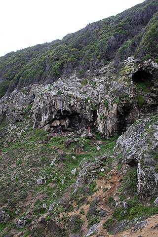
<span class="mw-page-title-main">Tsodilo</span> UNESCO World Heritage Site in Botswana

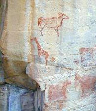
The Tsodilo Hills are a UNESCO World Heritage Site (WHS), consisting of rock art, rock shelters, depressions, and caves in southern Africa. It gained its WHS listing in 2001 because of its unique religious and spiritual significance to local peoples, as well as its unique record of human settlement over many millennia. UNESCO estimates there are over 4500 rock paintings at the site. The site consists of a few main hills known as the Child Hill, Female Hill, and Male Hill.

<span class="mw-page-title-main">Stanfield-Worley Bluff Shelter</span>

The Stanfield-Worley Bluff Shelter, located on private property in Colbert County in northwestern Alabama, United States, is one of the most important prehistoric sites excavated in the state due to the archeological evidence deposited by the Paleo-Indians who once occupied the rock shelter. Lying in Sanderson Cove along a tributary of Cane Creek approximately seven miles (11 km) south of the Tennessee Valley, the shelter and the high bluffs of the surrounding valley provided a well-protected environment for the Native American occupants.

<span class="mw-page-title-main">Fort Rock Cave</span> United States historic place

Fort Rock Cave was the site of the earliest evidence of human habitation in the US state of Oregon before the excavation of Paisley Caves. Fort Rock Cave featured numerous well-preserved sagebrush sandals, ranging from 9,000 to 13,000 years old. The cave is located approximately 1.5 miles (2.4 km) west of Fort Rock near Fort Rock State Natural Area in Lake County. Fort Rock Cave was declared a National Historic Landmark in 1961, and added to the National Register of Historic Places in 1966.

Mumba Cave, located near the highly alkaline Lake Eyasi in Karatu District, Arusha Region, Tanzania. The cave is a rich archaeological site noted for deposits spanning the transition between the Middle Stone Age and Late Stone Age in Eastern Africa. The transitional nature of the site has been attributed to the large presence of its large assemblage of ostrich eggshell beads and more importantly, the abundance of microlith technology. Because these type artifacts were found within the site it has led archaeologists to believe that the site could provide insight into the origins of modern human behavior. The cave was originally tested by Ludwig Kohl-Larsen and his wife Margit in their 1934 to 1936 expedition. They found abundant artifacts, rock art, and burials. However, only brief descriptions of these findings were ever published. That being said, work of the Kohl-Larsens has been seen as very accomplished due to their attention to detail, especially when one considers that neither was versed in proper archaeological techniques at the time of excavation. The site has since been reexamined in an effort to reanalyze and complement the work that has already been done, but the ramifications of improper excavations of the past are still being felt today, specifically in the unreliable collection of C-14 data and confusing stratigraphy.

<span class="mw-page-title-main">Padah-Lin Caves</span> Cave and archaeological site in Myanmar

The Padah-Lin Caves are limestone caves located in Taunggyi District, Shan State, Burma (Myanmar). It is located near a path from Nyaunggyat to Yebock, on a spur of the Nwalabo mountains within the Panlaung Reserved Forest. There are two caves; the smaller of the two is a rock shelter while the larger cave comprises nine chambers connected by narrow passages in a north-south axis, three large sinkholes that let natural light in, and several active speleothem formations.

<span class="mw-page-title-main">Franktown Cave</span> Archaeological site in Colorado, United States

Franktown Cave is located 25 miles (40 km) south of Denver, Colorado on the north edge of the Palmer Divide. It is the largest rock shelter documented on the Palmer Divide, which contains artifacts from many prehistoric cultures. Prehistoric hunter-gatherers occupied Franktown Cave intermittently for 8,000 years beginning about 6400 BC The site held remarkable lithic and ceramic artifacts, but it is better known for its perishable artifacts, including animal hides, wood, fiber and corn. Material goods were produced for their comfort, task-simplification and religious celebration. There is evidence of the site being a campsite or dwelling as recently as AD 1725.

The Cherry Creek Rockshelter is an archaeological site in central Colorado, located within modern-day Castlewood Canyon State Park near Franktown, Colorado. Current research indicates that it was used by Native American inhabitants beginning in the Archaic period. The site is situated on the Palmer Divide, which allowed for a unique prehistoric environment that contributed to an abundance of food and water sources, as well as lithic materials for tool-making. These factors, combined with the structure and situation of the shelter itself, made the site a particularly attractive environment for prehistoric peoples to settle in. Archaeological study of the site began in 1955, with the most current original research concluding in 2002.

The Lebombo bone is a bone tool made of a baboon fibula with incised markings discovered in Border Cave in the Lebombo Mountains located between South Africa and Eswatini. Changes in the section of the notches indicate the use of different cutting edges, which the bone's discoverer, Peter Beaumont, views as evidence for their having been made, like other markings found all over the world, during participation in rituals.

Hidden Cave is an archaeological cave site located in the Great Basin near Fallon, Nevada, United States. It got its name from Mark Harrington, who first excavated the cave and had a hard time finding the entrance, who said at the time, "This is one hidden cave!" It was excavated originally in the 1930s by Harrington and then excavated twice more before being returned to for the final time in 1978 by David Hurst Thomas for a more in depth excavation. The site dates back to the early Desert Archaic Culture from c. 4000 to 2000 years ago. Thousands of Archaic artifacts have been found here, and the site "provides important, if unusual clues about Desert Archaic lifeways". Hidden Cave was not lived in, but used as storage site for goods and tools for the 2000 years of its survival.

<span class="mw-page-title-main">Gault (archaeological site)</span>

The Gault archaeological site is an extensive, multicomponent site located in Florence, Texas, United States on the Williamson-Bell County line along Buttermilk Creek about 250 meters upstream from the Buttermilk Creek complex. It bears evidence of almost continuous human occupation, starting at least 16,000 years ago—making it one of the few archaeological sites in the Americas at which compelling evidence has been found for human occupation dating to before the appearance of the Clovis culture. Archaeological material covers about 16 hectares with a depth of up to 3 meters in places. About 30 incised stones from the Clovis period engraved with geometric patterns were found there as well as others from periods up to the Early Archaic. Incised bone was also found.

<span class="mw-page-title-main">Hidden Valley Rockshelter</span> Archaeological site in Virginia, United States

The Hidden Valley Rockshelter (44-BA-31) is a significant archaeological site located near the community of Warm Springs in Bath County, Virginia, United States. A large rockshelter located near the Jackson River, it has been occupied by humans for thousands of years, and it has been named a historic site.

The Kalemba Rockshelter is an archaeology site located in eastern Zambia, at coordinates 14°7 S and 32°3 E. Local tradition recalls the use of the rock shelter as a refuge during the time of Ngoni raiding in the 19th century. The site is known for various rock paintings as well as advanced microlithic use.
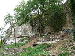
<span class="mw-page-title-main">Betal Rock Shelter</span> Cave and archaeological site in Slovenia

Betal Rock Shelter, a karst cave located on the south-eastern edge of the Lower Pivka river valley on a slope just above the road from Postojna to Bukovje is a site where rich cultural sediment layers with remains of stone tools, artifacts, and numerous fossilized bones of contemporary animals were found. Its entrance was formed by the collapse of the 174 m (571 ft) long cave's ceiling, carved out by the waters of the Pivka River.

<span class="mw-page-title-main">Castel Merle</span>

Castel Merle is a complex of 10 prehistoric rock shelters in Sergeac, in the Dordogne region of France. It is close to the Lascaux rock art caves and is situated in the region which forms the Unesco World Heritage site Prehistoric Sites and Decorated Caves of the Vézère Valley, but is not officially a part of it. The finds in the shelters date to the Mousterian and Magdalenian periods, or between 160,000 and 12,000 years ago. The most important of the 10 shelters is the Reverdit rockshelter.

The Fifield Site (Pr-55) is located on Damon Run Creek in Porter County, north-western Indiana. It is classified as a late prehistoric, single-component Upper Mississippian Fisher village.

The Huber Site (11Ck-1) is located on Tinley Creek 2 miles west of Blue Island in Cook County, Illinois, near the city of Chicago. It is classified as a late prehistoric site with Upper Mississippian affiliation.

The Anker Site (11Ck-21) is located on the Little Calumet River near Chicago, Illinois. It is classified as a late prehistoric site with Upper Mississippian Huber affiliation.

Church Rockshelter No.2 site situates near the Watauga River in Watauga County, North Carolina. It locates upstream from its twin site Church Rockshelter No.1 site. The No.2 site is east-southeast facing and includes two rock shelters formed by a Cranberry Gneiss outcrop. There is a lower shelter at the northern end and an upper shelter at the southern end. The site is owned by Charles Church, who discovered the site in the mid-1900s by finding many projectile points on the ground surface. A total of three excavations explored the site in the 1970s, 1975 and 2011 respectively. The site contains primarily stone and ceramic evidence from Early to Late Woodland period.

<span class="mw-page-title-main">Mlambalasi Rock Shelter</span> National Historic Site of Tanzania

The Mlambalasi Rock Shelter is a historic site located in Iringa District of Iringa Region in southern Tanzania, 50 km away from Iringa City. Excavations in 2006 and 2010 by the Iringa Region Archaeological Project uncovered artifactual deposits from the Later Stone Age (LSA), the Iron Age, and the historic periods, as well as external artifacts from the Middle Stone Age (MSA). Direct dating on Achatina shell and ostrich eggshell beads indicates that the oldest human burials at Mlambalasi are from the terminal Pleistocene. Mlambalasi is characterized by interment LSA and Iron Age periods, as well as by cycles of use and abandonment.

References

  1. "National Register Information System". National Register of Historic Places . National Park Service. April 15, 2008.
  2. "David Hurst Thomas". American Museum of Natural History. www.amnh.org.
  3. 1 2 3 4 5 6 7 8 9 10 11 12 13 14 15 16 17 National Register of Historic Places Inventory – Nomination Form. Name: Gatecliff Rockshelter (26NY301). Form prepared by Charles D. Zeier. December 1978.
  4. 1 2 3 4 5 6 7 8 9 10 11 12 13 14 15 16 Thomas, D. H. (1983). “Chapter 1 – Excavation Strategies.” The Archaeology of Monitor Valley: 2. Gatecliff. Anthropological Papers of the American Museum of Natural History. 59(1): 16-28.
  5. 1 2 3 4 5 6 7 8 Thomas, David H. and Robert L. Kelly. (2013). Archaeology. 6th edition. pp 38-90.
  6. 1 2 Gibbon, Guy E. et al. (1998). Archaeology of Prehistoric Native America: An Encyclopedia. Pp. 538.
  7. “Chapter 3 – Geology of Gatecliff Shelter: Physical Stratigraphy.” The Archaeology of Monitor Valley: 2. Gatecliff. Anthropological Papers of the American Museum of Natural History. 59(1): 39-63.
  8. 1 2 “Chapter 4 – Geology of Gatecliff Shelter: Sedimentary Facies and Holocene Climate.” The Archaeology of Monitor Valley: 2. Gatecliff. Anthropological Papers of the American Museum of Natural History. 59(1):64-87.
  9. 1 2 3 4 MaManamon, Francis P. (2009). Archaeology in America: An encycolopedia. Pp. 286.
  10. 1 2 3 4 5 6 Grayson, D. K. et al. (1983). “Chapter 6 – The Paleontology of Gatecliff Shelter.” The Archaeology of Monitor Valley: 2. Gatecliff. Anthropological Papers of the American Museum of Natural History. 59(1): 99-135.
  11. 1 2 Thomas, D. H. and Bierwirth, S. L. (1983). “Chapter 9 – Material Culture of Gatecliff Shelter: Projectile Points.” The Archaeology of Monitor Valley: 2. Gatecliff. Anthropological Papers of the American Museum of Natural History. 59(1): 177-211.
  12. 1 2 Thomas, David H. et al. (1983). “Chapter 10 – Material Culture of Gatecliff Shelter: Additional Stone Tools.” The Archaeology of Monitor Valley: 2. Gatecliff. Anthropological Papers of the American Museum of Natural History. 59(1): 212-245.
  13. 1 2 3 Thomas, T. (1983). “Chapter 11 – Material Culture of Gatecliff Shelter: Incised Stones.” The Archaeology of Monitor Valley: 2. Gatecliff. Anthropological Papers of the American Museum of Natural History. 59(1): 246-278.
  14. 1 2 3 4 Adovasio, J. M. and Andrews, R. L. (1983). “Chapter 12 – Material Culture of Gatecliff Shelter: Basketry, Cordage, and Miscellaneous Fiber Constructions.” The Archaeology of Monitor Valley: 2. Gatecliff. Anthropological Papers of the American Museum of Natural History. 59(1): 279-289.
  15. 1 2 Bennyhoff, J. A. and Hughes, R. E. (1983). “Chapter 13 – Material Culture of Gatecliff Shelter: Shell Beads and Ornaments.” The Archaeology of Monitor Valley: 2. Gatecliff. Anthropological Papers of the American Museum of Natural History. 59(1): 290-298.
  16. Thomas, D. H. (1983). “Chapter 14 – Material Culture of Gatecliff Shelter: Additional Artifacts.” The Archaeology of Monitor Valley: 2. Gatecliff. Anthropological Papers of the American Museum of Natural History. 59(1): 197-309.
  17. 1 2 3 4 5 Thomas, T. (1983). “Chapter 15 – Rock Art of Gatecliff Shelter.” The Archaeology of Monitor Valley: 2. Gatecliff. Anthropological Papers of the American Museum of Natural History. 59(1): 310-319.