Blombos Cave is an archaeological site located in Blombos Private Nature Reserve, about 300 km east of Cape Town on the Southern Cape coastline, South Africa. The cave contains Middle Stone Age (MSA) deposits currently dated at between c. 100,000 and 70,000 years Before Present (BP), and a Late Stone Age sequence dated at between 2000 and 300 years BP. The cave site was first excavated in 1991 and field work has been conducted there on a regular basis since 1997, and is ongoing.
The Big Eddy Site (23CE426) is an archaeological site located in Cedar County, Missouri, which was first excavated in 1997 and is now threatened due to erosion by the Sac River.
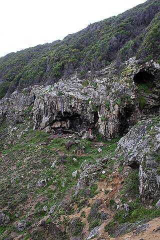
The Klasies River Caves are a series of caves located east of the Klasies River Mouth on the Tsitsikamma coast in the Humansdorp district of Eastern Cape Province, South Africa. The Klasies River Main (KRM) site consists of 3 main caves and 2 shelters located within a cliff on the southern coast of the Eastern Cape. The site provides evidence for developments in stone tool technology, evolution of modern human anatomy and behavior, and changes in paleoecology and climate in Southern Africa based on evidence from plant remains.
Balangoda Man refers to hominins from Sri Lanka's late Quaternary period. The term was initially coined to refer to anatomically modern Homo sapiens from sites near Balangoda that were responsible for the island's Mesolithic 'Balangoda Culture'. The earliest evidence of Balangoda Man from archaeological sequences at caves and other sites dates back to 38,000 BCE, and from excavated skeletal remains to 30,000 BC, which is also the earliest reliably dated record of anatomically modern humans in South Asia. Cultural remains discovered alongside the skeletal fragments include geometric microliths dating to 28,500 BC, which together with some sites in Africa is the earliest record of such stone tools.
Enkapune Ya Muto, also known as Twilight Cave, is a site spanning the late Middle Stone Age to the Late Stone Age on the Mau Escarpment of Kenya. This time span has allowed for further study of the transition from the Middle Stone Age to the Late Stone Age. In particular, the changes in lithic and pottery industries can be tracked over these time periods as well as transitions from a hunter-gatherer lifestyle to a herding lifestyle. Beads made of perforated ostrich egg shells found at the site have been dated to 40,000 years ago. The beads found at the site represent the early human use of personal ornaments. Inferences pertaining to climate and environment changes during the pre-Holocene and Holocene period have been made based from faunal remains based in this site.

Cueva Fell or Fell'sCave is a natural cave and archaeological site in southern Patagonia. Cueva Fell is in proximity to the Pali Aike Crater, another significant archaeological site. Cueva Fell combined with the nearby Pali Aike site have been submitted to UNESCO as a possible World Heritage Site.

Border Cave is an archaeological site located in the western Lebombo Mountains in Kwazulu-Natal. The rock shelter has one of the longest archaeological records in southern Africa, which spans from the Middle Stone Age to the Iron Age.
Minori Cave is part of the Callao limestone formation, located in Barangay Quibal, Municipality of Peñablanca, Cagayan Province in Northern Luzon. The said cave has two openings. One, designated as Mouth B, is located at 17° 43' 17" N latitude and 121° 49' 42" E longitude. The other opening, Mouth A is located 17° 43' 21" N latitude and 121° 49' 44" E longitude. The cave has an average elevation of about 200 m (656.2 ft) above sea level, and length and width of 147 m (482.3 ft) and 7 to 11 m, respectively. The cave is divided into four chambers with mouth A as chamber A and mouth B as chamber D. Chambers B and C are in between the two mouths.
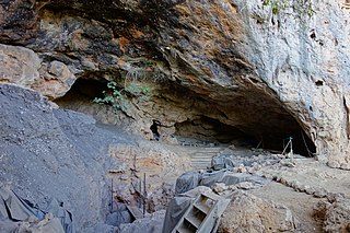
Taforalt, or Grotte des Pigeons, is a cave in the province of Berkane, Aït Iznasen region, Morocco, possibly the oldest cemetery in North Africa. It contained at least 34 Iberomaurusian adolescent and adult human skeletons, as well as younger ones, from the Upper Palaeolithic between 15,100 and 14,000 calendar years ago. There is archaeological evidence for Iberomaurusian occupation at the site between 23,200 and 12,600 calendar years ago, as well as evidence for Aterian occupation as old as 85,000 years.
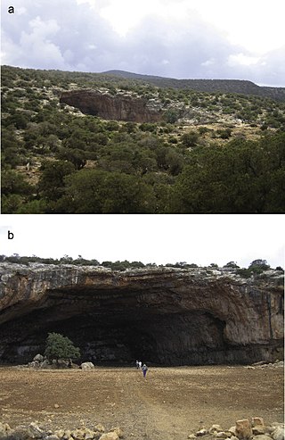
Haua Fteah is a large karstic cave located in the Cyrenaica in northeastern Libya. This site has been of significance to research on African archaeological history and anatomically modern human prehistory because it was occupied during the Middle and Upper Paleolithic, the Mesolithic and the Neolithic. Evidence of modern human presence in the cave date back to 200,000 BP.
The Gwisho hot-springs are an archaeological site in Lochinvar National Park, Zambia. The location is a rare site for its large quantity of preserved animal and plants remains. The site was first excavated by J. Desmond Clark in 1957, who found faunal remains and quartz tools in the western end of the site.
Gogo Falls is an archaeological site near a former and since 1956 dammed waterfall, located in the Lake Victoria Basin in Migori County, western Kenya. This site is important to archaeology as it includes some of the earliest appearances of artifacts and domestic animals in the area. The findings at the site help to reconstruct the later prehistory around Lake Victoria, including a Pastoral Neolithic occupation by Elmenteitan peoples and a later Iron Age occupation. Artifacts found at the site included pottery and iron artifacts. Through these artifacts some of the cultural traditions of the people who lived near Gogo Falls were discovered.
Elands Bay Cave is located near the mouth of the Verlorenvlei estuary on the Atlantic coast of South Africa's Western Cape Province. The climate has continuously become drier since the habitation of hunter-gatherers in the Later Pleistocene. The archaeological remains recovered from previous excavations at Elands Bay Cave have been studied to help answer questions regarding the relationship of people and their landscape, the role of climate change that could have determined or influenced subsistence changes, and the impact of pastoralism and agriculture on hunter-gatherer communities.
Melkhoutboom Cave is an archaeological site dating to the Later Stone Age, located in the Zuurberg Mountains, Cape Folded Mountain Belt, in the Addo Elephant National Park, Sarah Baartman District Municipality in the Eastern Cape Province of South Africa.
Boomplaas Cave is located in the Cango Valley in the foothills of the Swartberg mountain range, north of Oudtshoorn, Eden District Municipality in the Western Cape Province, South Africa. It has a 5 m (16 ft) deep stratified archaeological sequence of human presence, occupation and hunter-gatherer/herder acculturation that might date back as far as 80,000 years. The site's documentation contributed to the reconstruction of palaeo-environments in the context of changes in climate within periods of the Late Pleistocene and the Holocene. The cave has served multiple functions during its occupation, such as a kraal (enclosure) for animals, a place for the storage of oil rich fruits and as a hunting camp. Circular stone hearths and calcified dung remains of domesticated sheep as well as stone adzes and pottery art were excavated indicating that humans lived at the site and kept animals.

Pešturina is a cave in the municipality of Niška Banja in southeast Serbia. It is located southwest of Jelašnica and 20 km (12 mi) southeast of Niš. Artifacts from the Middle and Upper Paleolithic periods were discovered since the archaeological excavations began in 2006. The remains, identified as the Mousterian culture, were dated from 111,000 BP+ 5,000 to 39,000 BP + 3,000, which makes Pešturina one of the latest surviving Neanderthal habitats. The cave has been nicknamed the "Serbian Atapuerca".
Bambata Cave is one of the Southern Africa prehistoric sites situated in Motobo National Park along with Inanke, Nswatugi, Pomengwe and Silozwane caves in Zimbabwe.
Rose Cottage Cave (RCC) is an archaeological site in the Free State, South Africa, situated only a few kilometers away from Ladybrand, close to the Caledon River, on the northern slopes of the Platberg. RCC is an important site because of its long cultural sequence, its roots in modern human behavior, and the movement of early modern humans out of Africa. Rose Cottage is the only site from the Middle Stone Age that can tell us about the behavioral variability of hunter-gatherers during the Late Pleistocene and Holocene. Berry D. Malan excavated the site between 1943 and 1946, shortly followed by Peter B. Beaumont in the early 1960s, and the most recent excavations occurred from 1987 to 1997 by Lyn Wadley and Philip Harper in 1989 under Wadley's supervision. Humans have inhabited Rose Cottage for over 100,000 years throughout the Middle and Later Stone Ages. Site formation and sediment formation processes at Rose Cottage appear to be primarily anthropogenic. Archaeological research focuses primarily on blade technology and tool forms from the Middle Stone Age and the implications of modern human behavior. Structurally, the cave measures more than 6 meters deep and about 20 by 10 meters. A boulder encloses the front, protecting the cave, but allowing a small opening for a skylight and narrow entrances on both the east and west sides.
Porc-Epic Cave is an archaeological site located in Dire Dawa,Oromia, Ethiopia. Dated back to the Middle Stone Age, the site contains extensive evidence of microlithic tools, bone, and faunal remains. The lithic assemblage reveals that inhabitants at the time were well-organized with their environment. There is also rock art and strong evidence for ochre processing. The site was first discovered in 1920 by H. De Monfreid and P. Teilhard De Chardin. H. Breuil and P. Wernert performed the first excavation in 1933, followed from 1974 to 1976 by J. Desmond Clark and K.D. Williamson. Succeeding this was an excavation in 1998. Porc-Epic Cave provides insight into the behavior and technical capability of modern humans in eastern Africa during the Middle Stone Age.

The Mlambalasi Rock Shelter is a historic site located in Iringa District of Iringa Region in southern Tanzania, 50 km away from Iringa City. Excavations in 2006 and 2010 by the Iringa Region Archaeological Project uncovered artifactual deposits from the Later Stone Age (LSA), the Iron Age, and the historic periods, as well as external artifacts from the Middle Stone Age (MSA). Direct dating on Achatina shell and ostrich eggshell beads indicates that the oldest human burials at Mlambalasi are from the terminal Pleistocene. Mlambalasi is characterized by interment in the LSA and Iron Age periods, as well as by cycles of use and abandonment.