
The Snake River is a major river in the interior Pacific Northwest region of the United States. About 1,080 miles (1,740 km) long, it is the largest tributary of the Columbia River, which is the largest North American river that empties into the Pacific Ocean. Beginning in Yellowstone National Park, western Wyoming, it flows across the arid Snake River Plain of southern Idaho, the rugged Hells Canyon on the borders of Idaho, Oregon and Washington, and finally the rolling Palouse Hills of southeast Washington. It joins the Columbia River just downstream from the Tri-Cities, Washington, in the southern Columbia Basin.
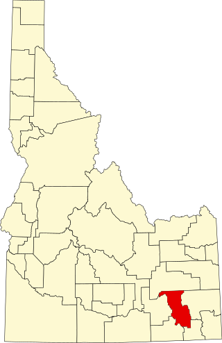
Bannock County is a county in the southeastern part of Idaho. As of the 2020 census, the population was 87,018, making it the sixth-most populous county in Idaho. The county seat and largest city is Pocatello. The county was established in 1893 and named after the local Bannock tribe. It is one of the counties with territories included in the Fort Hall Indian Reservation of the federally recognized Shoshone-Bannock Tribes.

Pocatello is the county seat and largest city of Bannock County, with a small portion on the Fort Hall Indian Reservation in neighboring Power County, in the southeastern part of the U.S. state of Idaho. It is the principal city of the Pocatello metropolitan area, which encompasses all of Bannock County.
Shoshone is the county seat and largest city of Lincoln County, Idaho, United States. The population was 1,461 at the 2010 census. In contrast to the Shoshone Native American tribe for which it is named, the city's name is correctly pronounced "Show-shown", with a silent "e".

Lava Beds National Monument is located in northeastern California, in Siskiyou and Modoc counties. The monument lies on the northeastern flank of Medicine Lake Volcano, which is the largest volcano by area in the Cascade Range.

Craters of the Moon National Monument and Preserve is a U.S. national monument and national preserve in the Snake River Plain in central Idaho. It is along US 20, between the small towns of Arco and Carey, at an average elevation of 5,900 feet (1,800 m) above sea level.

The Snake River Plain is a geologic feature located primarily within the U.S. state of Idaho. It stretches about 400 miles (640 km) westward from northwest of the state of Wyoming to the Idaho-Oregon border. The plain is a wide, flat bow-shaped depression and covers about a quarter of Idaho. Three major volcanic buttes dot the plain east of Arco, the largest being Big Southern Butte.
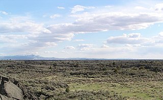
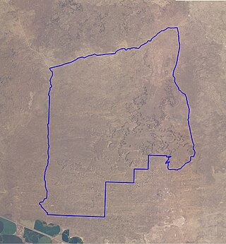
Hell's Half Acre Lava Field is a basaltic lava plain located on the Snake River Plain of Idaho in the United States. It is the easternmost of the basaltic lava fields on the Snake River Plain, located about 25 miles (40 km) west of Idaho Falls, Idaho and 30 miles (48 km) north of Pocatello, Idaho. In 1976, the National Park Service designated the northwestern portion of the site a National Natural Landmark. In 1986, the Bureau of Land Management recommended that 68,760 acres (27,830 ha) of the site, located just southeast of the National Natural Landmark, to be a wilderness study area.

Fort Rock Cave was the site of the earliest evidence of human habitation in the US state of Oregon before the excavation of the Paisley Caves. Fort Rock Cave featured numerous well-preserved sagebrush sandals, ranging from 9,000 to 13,000 years old. The cave is located approximately 1.5 miles (2.4 km) west of Fort Rock near Fort Rock State Natural Area in Lake County. Fort Rock Cave was declared a National Historic Landmark in 1961, and added to the National Register of Historic Places in 1966.

The Idaho Transportation Department (ITD) is the state of Idaho governmental organization responsible for state transportation infrastructure. This includes ongoing operations and maintenance as well as planning for future needs of the state and its citizens. The agency is responsible for overseeing the disbursement of federal, state, and grant funding for transportation programs in the state.

The Fossil Falls is a unique geological feature, located in the Coso Range of California in the United States. Volcanic activity in the mountain range, along with meltwater from glaciers in the nearby Sierra Nevada, played a role in the creation of the falls. They are located near the community of Little Lake, 1.0 mi (1.6 km) off US 395 on Cinder Road to Red Hill, with signs to Fossil Falls.
Fort Rock–Christmas Lake Valley is a basin of a former inland sea that existed in that region from Pliocene through late Pleistocene time.

The Horse Lava Tube System is a series of lava tubes within Deschutes County, Oregon, of the United States. The system starts within the Deschutes National Forest on the northern flank of Newberry Volcano and heads north into and near the city of Bend. The system continues north to Redmond and includes the Redmond Caves. The flow diverts into the Redmond Dry Canyon, where the last known segment is known to exist; however, the basalt flow that created the system goes beyond to Crooked River Ranch and terminates just short of the Crooked River Gorge. The lava flow that created the Horse system is also referred to as the Horse Cave lobe and it filled the ancient channel of the Deschutes River which at that time flowed around the east side of Pilot Butte. The Horse Cave lobe is a part of the basalt of Lava Top Butte which also consists of the Arnold Lava Tube System, the Badlands rootless shield, and the Lava Top butte basalt. All have a geologic age around 80,000 years old.

Salmon Falls Creek is a tributary of the Snake River, flowing from northern Nevada into Idaho in the United States. Formed in high mountains at the northern edge of the Great Basin, Salmon Falls Creek flows northwards 121 miles (195 km), draining an arid and mountainous basin of 2,103 square miles (5,450 km2). The Salmon Falls Creek valley served as a trade route between the Native American groups of the Snake River Plain and Great Basin. Today, most of its water is used for irrigation.

Hager Mountain is a volcanic peak in Oregon in the northwest corner of the Basin and Range Province in the United States. The mountain is located south of the small unincorporated community of Silver Lake in south-central Oregon, and it is in the Fremont–Winema National Forest. On the summit, there is a fire lookout operated during the summer and fall by the United States Forest Service. There are several hiking trails that lead to the lookout station.
Black Magic Canyon is a small canyon located north of Shoshone, Idaho along Idaho State Highway 75. It was created by the Big Wood River over the last 10,000 years. The river carved this canyon through 800,000-year-old basalt lava flows leaving sculpted black rock reminiscent of Utah's slot canyons. Because of irrigation use during the summer and snowfall in winter, the canyon is best explored in spring or fall.

The Guffey Butte–Black Butte Archeological District is a 14,000 acres (57 km2) historic district in southwestern Idaho, United States, that is listed on the National Register of Historic Places (NRHP). It includes numerous archeological sites in Ada, Canyon, Elmore, and Owyhee counties.
The Shale Butte Wilderness Study Area is a Bureau of Land Management wilderness study area (WSA) in Lincoln County, Idaho. It covers 15,560 acres (6,300 ha). The WSA is located to the south of Craters of the Moon National Monument and Preserve.

The Sand Butte Wilderness Study Area is a Bureau of Land Management wilderness study area (WSA) in Lincoln County, Idaho. It covers about 21,000 acres (8,500 ha). The WSA is located to the south of Craters of the Moon National Monument and Preserve.

The Nampa figurine is a 1.5-inch (38 mm) fired clay doll found near Nampa, Idaho, in 1889. The figurine has been dyed red, possibly due to iron oxide deposition, and depicts a female figure with jewelry and clothing. The artifact has been the subject of substantial controversy over its apparent age. While scholarly consensus today holds that the doll is a hoax, initial estimates of the artifact placed its age at 2 million years old, significantly outdating any other clay artifacts and humanity's arrival in the Americas.


