
The Great Serpent Mound is a 1,348-feet-long (411 m), three-feet-high prehistoric effigy mound located in Peebles, Ohio. It was built on what is known as the Serpent Mound crater plateau, running along the Ohio Brush Creek in Adams County, Ohio. The mound is the largest serpent effigy known in the world.

The Grave Creek Mound in the Ohio River Valley in West Virginia is one of the largest conical-type burial mounds in the United States, now standing 62 feet (19 m) high and 240 feet (73 m) in diameter. The builders of the site, members of the Adena culture, moved more than 60,000 tons of dirt to create it about 250–150 BC.
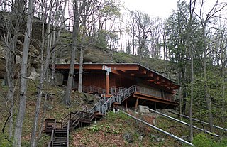
The Meadowcroft Rockshelter is an archaeological site which is located near Avella in Jefferson Township, Pennsylvania. The site is a rock shelter in a bluff overlooking Cross Creek, and contains evidence that the area may have been continually inhabited for more than 19,000 years. If accurately dated, it would be one of the earliest known sites with evidence of a human presence and continuous human occupation in the New World.

Rock Eagle Effigy Mound is an archaeological site in Putnam County, Georgia, U.S. estimated to have been constructed c. 1000 BC to AD 1000. The earthwork was built up of thousands of pieces of quartzite laid in the mounded shape of a large bird. Although it is most often referred to as an eagle, scholars do not know exactly what type of bird the original builders intended to portray. It is listed on the National Register of Historic Places (NRHP) because of its significance. The University of Georgia administers the site. It uses much of the adjoining land for a 4-H camp, with cottages and other buildings, and day and residential environmental education.

Gatecliff Rockshelter (26NY301) is a major archaeological site in the Great Basin area of the western United States that provides remarkable stratigraphy; it has been called the "deepest archaeological rock shelter in the Americas". Located in Mill Canyon of the Toquima Range in the Monitor Valley of central Nevada, Gatecliff Rockshelter has an elevation of 7,750 feet (2,360 m). David Hurst Thomas discovered Gatecliff Rockshelter in 1970 and began excavations in 1971. Full scale excavations occurred at Gatecliff Rockshelter for about seven field seasons in which nearly 33 feet (10 m) of sediments were exposed for a well-defined stratigraphic sequence. The well-preserved artifacts and undisturbed sediments at Gatecliff Rockshelter provides data and information have been applied to a range of research topics. Based on the analysis of the artifacts at Gatecliff Rockshelter, it can be determined that it was most likely a short-term field camp throughout prehistory. The latest evidence for human usage at Gatecliff occurs between ca. 5500 B.P. to 1250 B.P.
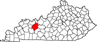
Indian Knoll is an archaeological site near the Green River in Ohio County, Kentucky that was declared to be a U.S. National Historic Landmark.
The Green River Shell Middens Archeological District is a historic district composed of archaeological sites in the U.S. state of Kentucky. All of the district's sites are shell middens along the banks of the Green River that date from the later portion of the Archaic period. Studies of this assemblage of sites were critical in the development of knowledge of the Archaic period in the eastern United States.
The Prehistory of West Virginia spans ancient times until the arrival of Europeans in the early 17th century. Hunters ventured into West Virginia's mountain valleys and made temporary camp villages since the Archaic period in the Americas. Many ancient human-made earthen mounds from various mound builder cultures survive, especially in the areas of Moundsville, South Charleston, and Romney. The artifacts uncovered in these areas give evidence of a village society with a tribal trade system culture that included limited cold worked copper. As of 2009, over 12,500 archaeological sites have been documented in West Virginia.

This is a list of the National Register of Historic Places listings in Butler County, Kentucky.
This is a list of the National Register of Historic Places listings in Ohio County, Kentucky.

This is a list of the National Register of Historic Places listings in McLean County, Kentucky.
The Chauga Mound (38OC1) is an archaeological site once located on the northern bank of the Tugaloo River, about 1,200 feet (370 m) north of the mouth of the Chauga River in present-day Oconee County, South Carolina. The earthen platform mound and former village site were inundated by creation of Lake Hartwell after construction of the Hartwell Dam on the Savannah River, which was completed in 1962.
The Carlston Annis Shell Mound is a prominent archaeological site in the western part of the U.S. state of Kentucky. Located along the Green River in Butler County, this shell midden has been declared a historic site because of its archaeological value.
The Ramey Mound, designated 15BH1, is an archaeological site in Bath County in the northeastern part of the U.S. state of Kentucky. Built by people of the prehistoric Adena culture, the site has been known for more than two centuries; it was recorded in 1807 as consisting of an enclosure at least 3 feet (0.91 m) high. In 1871, another survey observed four mounds in association with the main earthwork: one was located just east of the enclosure, another directly to the west, a larger one to the southeast, and a small one to the southwest. The source of a nearby brook lies within the site and transverses the enclosure; the 1871 survey supposed that it had been dug to provide earth for the enclosure. By the time of this later survey, cultivation had reduced the earthwork to the point that it was nearly indistinguishable.

The Blackrock Springs Site (44-AU-167) is an archaeological site in Shenandoah National Park, in Augusta County, Virginia, United States.

The Rockhouse Cliffs Rockshelters are a pair of rockshelters in the far southern region of the U.S. state of Indiana. Located amid broken terrain in the Hoosier National Forest, the shelters may have been inhabited for more than ten thousand years by peoples ranging from the Early Archaic period until the twentieth century. As a result of their extensive occupation and their remote location, they are important and well-preserved archaeological sites and have been named a historic site.
The LaGrange Rock Shelter is an archaeological site located on private property between Leighton and Muscle Shoals in Colbert County, Alabama, near the original campus of LaGrange College. The shelter measures 70 feet long by 15 feet deep and is located beneath a sandstone outcrop overlooking a dense series of Paleoindian sites in the valley below, which may have led to it being chosen for excavation.

Tainter Cave, also known as Tombstone Cave, is a dry sandstone cave in Crawford County, Wisconsin, in which prehistoric Native Americans carved petroglyphs and drew pictographs, including birds, men, deer, and abstract designs. With over 100 pictographs, the cave holds more than any other known site in Wisconsin. It is also notable as the first archaeological site recorded in the dark zone of a cave in the Upper Midwest.
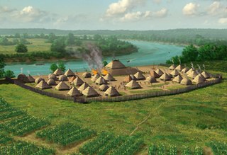
The Annis Mound and Village site is a prehistoric Middle Mississippian culture archaeological site located on the bank of the Green River in Butler County, Kentucky, several miles northwest of Morgantown in the Big Bend region. It was occupied from about 800 CE to about 1300 CE.

