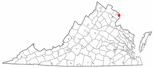
[3] Name on the Register Image Date listed [4] Location City or town Description 1 "A" Fort and Battery Hill Redoubt-Camp Early "A" Fort and Battery Hill Redoubt-Camp Early October 30, 1998 (# 98001315 Balmoral Greens Ave., 1 mile (1.6 km) south of the junction with Compton Rd. 38°47′22″N 77°25′40″W / 38.7894°N 77.4278°W / 38.7894; -77.4278 ("A" Fort and Battery Hill Redoubt-Camp Early ) Manassas Park 2 Belvoir Mansion Ruins and the Fairfax Grave Belvoir Mansion Ruins and the Fairfax Grave June 4, 1973 (# 73002337 Southeast of the junction of 23rd St. and Belvoir Rd. 38°40′51″N 77°07′42″W / 38.6807°N 77.1283°W / 38.6807; -77.1283 (Belvoir Mansion Ruins and the Fairfax Grave ) Fort Belvoir 3 Bloomfield Bloomfield February 5, 2013 (# 12001266 12000 Leesburg Pike 39°00′37″N 77°21′34″W / 39.0103°N 77.3594°W / 39.0103; -77.3594 (Bloomfield ) Herndon 4 Bois Doré Upload image December 7, 2020 (# 100005880 8008 Georgetown Pike 38°57′40″N 77°13′20″W / 38.9612°N 77.2221°W / 38.9612; -77.2221 (Bois Doré ) McLean 5 A. Smith Bowman Distillery A. Smith Bowman Distillery December 9, 1999 (# 99001503 1875 Old Reston Ave. 38°57′24″N 77°21′05″W / 38.9567°N 77.3514°W / 38.9567; -77.3514 (A. Smith Bowman Distillery ) Reston 6 Civil War Fort Sites Civil War Fort Sites July 15, 1974 (# 74000274 Arc of sites surrounding central Washington in Maryland, Virginia, and D.C. 38°56′02″N 77°07′34″W / 38.9339°N 77.1261°W / 38.9339; -77.1261 (Civil War Fort Sites ) McLean At the outset of the Civil War in 1861, Washington became a critical target for rebel attacks but was virtually without protection. The Union Army hastily began construction of a fortified defense line around the city, the physical remnants of which encompass these 19 earthwork forts, including Fort Marcy . [5] See also National Register listings in central D.C. , western NW D.C. , upper NW D.C. , NE D.C. , SE D.C. , and Prince George's County, Maryland . 7 Clifton Historic District Clifton Historic District August 15, 1985 (# 85001786 Roughly bounded by Popes Head Creek, Water St., Dell Ave., and Chestnut and Chapel Rds. 38°46′46″N 77°23′11″W / 38.7794°N 77.3864°W / 38.7794; -77.3864 (Clifton Historic District ) Clifton 8 Colvin Run Mill Colvin Run Mill August 16, 1977 (# 77001487 South of Great Falls at 10017 Colvin Run Rd. 38°58′07″N 77°17′35″W / 38.9686°N 77.2931°W / 38.9686; -77.2931 (Colvin Run Mill ) Great Falls 9 Cornwell Farm Cornwell Farm April 13, 1977 (# 77001488 Southeast of Great Falls, 9414 Georgetown Pike 38°59′29″N 77°16′17″W / 38.9915°N 77.2714°W / 38.9915; -77.2714 (Cornwell Farm ) Great Falls 10 D.C. Workhouse and Reformatory Historic District D.C. Workhouse and Reformatory Historic District February 16, 2006 (# 06000052 Between Silverbrook Rd., Lorton Rd., Ox Rd., and Furnace Rd. 38°41′53″N 77°15′16″W / 38.6981°N 77.2544°W / 38.6981; -77.2544 (D.C. Workhouse and Reformatory Historic District ) Lorton 11 Dranesville Tavern Dranesville Tavern November 9, 1972 (# 72001393 11919 Leesburg Pike 39°00′29″N 77°21′37″W / 39.0081°N 77.3603°W / 39.0081; -77.3603 (Dranesville Tavern ) Dranesville 12 Drover's Rest Upload image June 20, 2023 (# 100009070 8526 Georgetown Pk. 38°58′06″N 77°14′23″W / 38.9682°N 77.2398°W / 38.9682; -77.2398 (Drover's Rest ) McLean 13 Fairfax Arms Fairfax Arms May 21, 1979 (# 79003037 10712 Old Colchester Rd. 38°40′06″N 77°14′08″W / 38.6683°N 77.2356°W / 38.6683; -77.2356 (Fairfax Arms ) Colchester 14 Floris Historic District Floris Historic District August 12, 2010 (# 10000543 Bounded by Centreville Rd., W. Ox Rd., Monroe St., and Frying Pan Branch 38°56′11″N 77°24′35″W / 38.9364°N 77.4097°W / 38.9364; -77.4097 (Floris Historic District ) Herndon 15 Fort Hunt Fort Hunt March 26, 1980 (# 80000353 George Washington Memorial Parkway 38°42′54″N 77°03′07″W / 38.7150°N 77.0519°W / 38.7150; -77.0519 (Fort Hunt ) Alexandria 16 Four Stairs Four Stairs August 11, 2004 (# 04000842 840 Leigh Mill Rd. 38°59′04″N 77°16′36″W / 38.9844°N 77.2767°W / 38.9844; -77.2767 (Four Stairs ) Great Falls 17 Freeman Store Freeman Store May 16, 2012 (# 11000834 131 Church St., NE. 38°54′12″N 77°15′54″W / 38.9033°N 77.2650°W / 38.9033; -77.2650 (Freeman Store ) Vienna 18 Frying Pan Meetinghouse Frying Pan Meetinghouse February 5, 1991 (# 91000016 2615 Centreville Rd. 38°56′24″N 77°24′47″W / 38.9400°N 77.4131°W / 38.9400; -77.4131 (Frying Pan Meetinghouse ) Floris 19 George Washington Memorial Parkway George Washington Memorial Parkway June 2, 1995 (# 95000605 Roughly the southern side of the Potomac River from the American Legion to the Memorial Bridge and the north side from Brickyard Rd. to the Chain Bridge 38°57′38″N 77°08′54″W / 38.9606°N 77.1483°W / 38.9606; -77.1483 (George Washington Memorial Parkway ) Langley 20 Georgetown Pike Georgetown Pike August 22, 2012 (# 12000537 From the District of Columbia boundary at the Chain Bridge to the junction with Leesburg Pike at Seneca Rd. 38°57′14″N 77°11′31″W / 38.9539°N 77.1919°W / 38.9539; -77.1919 (Georgetown Pike ) McLean Extends into Arlington County 21 Great Falls Grange Hall and Forestville School Great Falls Grange Hall and Forestville School August 11, 2004 (# 04000861 9812 and 9818 Georgetown Pike 38°59′52″N 77°17′08″W / 38.9978°N 77.2856°W / 38.9978; -77.2856 (Great Falls Grange Hall and Forestville School ) Great Falls 22 Great Falls Park Historic District Great Falls Park Historic District December 22, 2014 (# 14001079 Bounded by the Potomac River , Georgetown Pike, and River Bend Rd. 38°59′30″N 77°15′02″W / 38.9917°N 77.2506°W / 38.9917; -77.2506 (Great Falls Park Historic District ) Great Falls 23 Green Spring Green Spring October 22, 2003 (# 03001089 4601 Green Spring Rd. 38°49′28″N 77°09′26″W / 38.8244°N 77.1572°W / 38.8244; -77.1572 (Green Spring ) Alexandria 24 John Gunnell House John Gunnell House November 27, 2006 (# 06001100 489 Arnon Meadow Rd. 39°00′48″N 77°17′23″W / 39.013333°N 77.289722°W / 39.013333; -77.289722 (John Gunnell House ) Great Falls 25 William Gunnell House William Gunnell House May 22, 2003 (# 03000447 600 Insbruck Ave. 39°00′13″N 77°17′05″W / 39.003611°N 77.284722°W / 39.003611; -77.284722 (William Gunnell House ) Great Falls 26 Gunston Hall Gunston Hall October 15, 1966 (# 66000832 10709 Gunston Rd. 38°39′51″N 77°09′37″W / 38.664167°N 77.160278°W / 38.664167; -77.160278 (Gunston Hall ) Mason Neck 27 Herndon Depot Herndon Depot June 18, 1979 (# 79003039 Elden St. 38°58′13″N 77°23′12″W / 38.970278°N 77.386583°W / 38.970278; -77.386583 (Herndon Depot ) Herndon 28 Herndon Historic District Herndon Historic District January 11, 1991 (# 90002121 Roughly bounded by Locust, Spring, Pearl, Monroe, Station, and Vine Sts. 38°58′06″N 77°23′05″W / 38.968333°N 77.384722°W / 38.968333; -77.384722 (Herndon Historic District ) Herndon 29 Hollin Hills Historic District Hollin Hills Historic District September 30, 2013 (# 13000807 Roughly Beechwood, Elba, Glasgow, Martha's, Paul Springs, Range, and Stafford Rds., and Mason Hill, Rebecca, and Whiteoaks Drs. 38°45′24″N 77°04′02″W / 38.756667°N 77.067222°W / 38.756667; -77.067222 (Hollin Hills Historic District ) Alexandria 30 Holmes Run Acres Historic District Holmes Run Acres Historic District March 22, 2007 (# 07000230 Generally bounded by Gallows Rd., Surrey Ln, and Holmes Run Dr. 38°51′09″N 77°12′38″W / 38.852500°N 77.210556°W / 38.852500; -77.210556 (Holmes Run Acres Historic District ) Falls Church 31 Hope Park Mill and Miller's House Hope Park Mill and Miller's House August 15, 1977 (# 77001486 12124 Pope's Head Rd. 38°48′55″N 77°21′56″W / 38.815139°N 77.365694°W / 38.815139; -77.365694 (Hope Park Mill and Miller's House ) Fairfax 32 Huntley Huntley November 3, 1972 (# 72001392 6918 Harrison Lane 38°45′56″N 77°05′41″W / 38.765694°N 77.094722°W / 38.765694; -77.094722 (Huntley ) Alexandria 33 Langley Fork Historic District Langley Fork Historic District October 19, 1982 (# 82001818 Junction of Georgetown Pike and Old Chain Bridge Rd. 38°56′46″N 77°09′36″W / 38.946111°N 77.16°W / 38.946111; -77.16 (Langley Fork Historic District ) Langley 34 Lake Anne Village Center Historic District Lake Anne Village Center Historic District June 5, 2017 (# 100001041 North Shore Dr. and Washington Plaza W. and N. 38°58′08″N 77°20′27″W / 38.968889°N 77.340833°W / 38.968889; -77.340833 (Lake Anne Village Center Historic District ) Reston 35 Lexington Lexington May 28, 2013 (# 13000336 7301 High Point Rd. 38°39′37″N 77°10′28″W / 38.660278°N 77.174444°W / 38.660278; -77.174444 (Lexington ) Lorton 36 Manassas National Battlefield Park Manassas National Battlefield Park October 15, 1966 (# 66000039 Northwest of Manassas off State Route 215 38°49′28″N 77°30′12″W / 38.824444°N 77.503333°W / 38.824444; -77.503333 (Manassas National Battlefield Park ) Manassas 37 Merrybrook Merrybrook April 26, 2007 (# 07000362 2346 Centreville Rd. 38°57′14″N 77°24′30″W / 38.953889°N 77.408333°W / 38.953889; -77.408333 (Merrybrook ) Herndon 38 Mount Vernon Mount Vernon October 15, 1966 (# 66000833 7 miles (11 km) south of Alexandria on the George Washington Memorial Parkway 38°42′29″N 77°05′10″W / 38.708056°N 77.086111°W / 38.708056; -77.086111 (Mount Vernon ) Alexandria 39 Mount Vernon Enterprise Lodge #3488-Pride of Fairfax County Lodge #298 Mount Vernon Enterprise Lodge #3488-Pride of Fairfax County Lodge #298 April 14, 2022 (# 100007613 7809 Fordson Rd. 38°44′47″N 77°04′51″W / 38.7463°N 77.0809°W / 38.7463; -77.0809 (Mount Vernon Enterprise Lodge #3488-Pride of Fairfax County Lodge #298 ) Alexandria vicinity 40 Mount Vernon High School Mount Vernon High School May 11, 2018 (# 100002439 8333 Richmond Highway 38°43′53″N 77°06′06″W / 38.731389°N 77.101667°W / 38.731389; -77.101667 (Mount Vernon High School ) Alexandria The 1939 building, not the current school. 41 Mount Vernon Memorial Highway Mount Vernon Memorial Highway May 18, 1981 (# 81000079 Washington St. and the George Washington Memorial Parkway 38°46′30″N 77°03′07″W / 38.775000°N 77.051944°W / 38.775000; -77.051944 (Mount Vernon Memorial Highway ) McLean The portion of the George Washington Memorial Parkway from the Arlington Memorial Bridge to Mount Vernon 42 Northwest No. 1 Boundary Marker of the Original District of Columbia Northwest No. 1 Boundary Marker of the Original District of Columbia February 1, 1991 (# 91000003 3607 Powhatan St. 38°54′12″N 77°09′33″W / 38.903472°N 77.159167°W / 38.903472; -77.159167 (Northwest No. 1 Boundary Marker of the Original District of Columbia ) McLean 43 Northwest No. 2 Boundary Marker of the Original District of Columbia Northwest No. 2 Boundary Marker of the Original District of Columbia February 1, 1991 (# 91000004 5145 N. 38th St. 38°54′49″N 77°08′46″W / 38.913667°N 77.146111°W / 38.913667; -77.146111 (Northwest No. 2 Boundary Marker of the Original District of Columbia ) McLean 44 Northwest No. 3 Boundary Marker of the Original District of Columbia Northwest No. 3 Boundary Marker of the Original District of Columbia February 1, 1991 (# 91000005 4013 N. Tazewell St. 38°55′28″N 77°07′55″W / 38.924583°N 77.132083°W / 38.924583; -77.132083 (Northwest No. 3 Boundary Marker of the Original District of Columbia ) McLean 45 Oak Hill Oak Hill May 19, 2004 (# 04000478 4716 Wakefield Chapel Rd. 38°49′15″N 77°14′24″W / 38.820972°N 77.240000°W / 38.820972; -77.240000 (Oak Hill ) Annandale 46 Oakton Trolley Station Oakton Trolley Station February 8, 1995 (# 95000026 2923 Gray St. 38°52′46″N 77°17′49″W / 38.879444°N 77.296944°W / 38.879444; -77.296944 (Oakton Trolley Station ) Oakton 47 Orange and Alexandria Railroad Bridge Piers Orange and Alexandria Railroad Bridge Piers August 8, 1989 (# 89001061 Both sides of Bull Run just east of Manassas Park [6] 38°46′35″N 77°25′17″W / 38.776389°N 77.421389°W / 38.776389; -77.421389 (Orange and Alexandria Railroad Bridge Piers ) Manassas Park Extends into Prince William County 48 Pohick Church Pohick Church October 16, 1969 (# 69000239 9201 U.S. Route 1 38°42′33″N 77°11′38″W / 38.709028°N 77.193889°W / 38.709028; -77.193889 (Pohick Church ) Lorton 49 Pope-Leighey House Pope-Leighey House December 18, 1970 (# 70000791 East of Accotink off U.S. Route 1 38°43′10″N 77°08′10″W / 38.719444°N 77.136111°W / 38.719444; -77.136111 (Pope-Leighey House ) Accotink 50 Potomac Canal Historic District Potomac Canal Historic District October 18, 1979 (# 79003038 East of Great Falls 38°59′44″N 77°15′14″W / 38.995556°N 77.253889°W / 38.995556; -77.253889 (Potomac Canal Historic District ) Great Falls 51 St. Mary's Church St. Mary's Church July 1, 1976 (# 76002104 5605 Vogue Rd. 38°48′10″N 77°19′36″W / 38.802778°N 77.326667°W / 38.802778; -77.326667 (St. Mary's Church ) Fairfax Station 52 Salona Salona July 24, 1973 (# 73002011 1214 Buchanan St. 38°56′17″N 77°10′15″W / 38.937917°N 77.170833°W / 38.937917; -77.170833 (Salona ) McLean 53 Silverbrook Methodist Church Silverbrook Methodist Church January 16, 2004 (# 03001438 8616 Silverbrook Rd. 38°43′33″N 77°14′35″W / 38.725833°N 77.242917°W / 38.725833; -77.242917 (Silverbrook Methodist Church ) Lorton 54 Southwest No. 6 Boundary Marker of the Original District of Columbia Southwest No. 6 Boundary Marker of the Original District of Columbia February 1, 1991 (# 91000011 S. Jefferson St. south of the junction with Columbia Pike, in the median strip 38°51′07″N 77°07′09″W / 38.8519°N 77.1192°W / 38.8519; -77.1192 (Southwest No. 6 Boundary Marker of the Original District of Columbia ) Bailey's Crossroads 55 Southwest No. 7 Boundary Marker of the Original District of Columbia Southwest No. 7 Boundary Marker of the Original District of Columbia February 1, 1991 (# 91000012 Behind 3101 S. Manchester St. 38°51′45″N 77°07′58″W / 38.8625°N 77.1328°W / 38.8625; -77.1328 (Southwest No. 7 Boundary Marker of the Original District of Columbia ) Seven Corners 56 Southwest No. 8 Boundary Marker of the Original District of Columbia Southwest No. 8 Boundary Marker of the Original District of Columbia February 1, 1991 (# 91000013 Junction of Wilson Boulevard and John Marshall Dr., behind an apartment building 38°52′21″N 77°08′45″W / 38.8726°N 77.1458°W / 38.8726; -77.1458 (Southwest No. 8 Boundary Marker of the Original District of Columbia ) Seven Corners Extends into Arlington County 57 Spring Hill Farm Spring Hill Farm November 22, 2002 (# 02000446 1121 Spring Hill Rd. 38°56′53″N 77°13′32″W / 38.9481°N 77.2256°W / 38.9481; -77.2256 (Spring Hill Farm ) McLean 58 Sully Sully December 18, 1970 (# 70000793 North of the junction of U.S. Route 50 and State Route 28 38°54′28″N 77°25′51″W / 38.9078°N 77.4308°W / 38.9078; -77.4308 (Sully ) Chantilly 59 Sydenstricker School Sydenstricker School August 22, 2012 (# 12000539 8511 Hooes Rd. 38°45′21″N 77°14′21″W / 38.7557°N 77.2392°W / 38.7557; -77.2392 (Sydenstricker School ) Springfield 60 Taft Archeological Site#029-5411 Taft Archeological Site#029-5411 August 11, 2004 (# 04000859 Address Restricted 38°38′55″N 77°11′40″W / 38.6486°N 77.1944°W / 38.6486; -77.1944 (Taft Archeological Site#029-5411 ) Lorton 61 Tauxemont Historic District Tauxemont Historic District February 9, 2006 (# 06000033 Between Fort Hunt Rd. and Accotink Place, including Shenandoah, Tauxemont, Namassin, Westmoreland and Gahant Rds., and Bolling 38°44′42″N 77°03′20″W / 38.7450°N 77.0556°W / 38.7450; -77.0556 (Tauxemont Historic District ) Alexandria 62 Tower House Tower House May 2, 2006 (# 06000341 9066 Tower House Place 38°42′41″N 77°04′01″W / 38.7114°N 77.0669°W / 38.7114; -77.0669 (Tower House ) Alexandria 63 U. S. Geological Survey National Center U. S. Geological Survey National Center August 10, 2020 (# 100005414 12201 Sunrise Valley Dr. 38°56′59″N 77°22′04″W / 38.9497°N 77.367667°W / 38.9497; -77.367667 (U. S. Geological Survey National Center ) Reston 64 Vale School-Community House Vale School-Community House June 8, 2011 (# 11000349 3124 Fox Mill Rd. 38°53′30″N 77°20′56″W / 38.8917°N 77.3489°W / 38.8917; -77.3489 (Vale School-Community House ) Oakton 65 George Washington's Gristmill George Washington's Gristmill August 8, 2003 (# 03000739 5512 George Washington Memorial Parkway 38°42′47″N 77°07′48″W / 38.7131°N 77.1300°W / 38.7131; -77.1300 (George Washington's Gristmill ) Lorton 66 West Cornerstone West Cornerstone February 1, 1991 (# 91000014 West side of Meridian St., south of the junction with Williamsburg Boulevard 38°53′36″N 77°10′20″W / 38.8933°N 77.1722°W / 38.8933; -77.1722 (West Cornerstone ) Falls Church 67 Woodlawn Plantation Woodlawn Plantation February 26, 1970 (# 70000792 West of the junction of U.S. Route 1 and State Route 235 ; also 9000 U.S. Route 1 38°43′03″N 77°08′14″W / 38.7175°N 77.1372°W / 38.7175; -77.1372 (Woodlawn Plantation ) Alexandria 9000 Richmond represents a boundary increase of November 18, 2011 68 Woodlawn Quaker Meetinghouse Woodlawn Quaker Meetinghouse May 21, 2009 (# 09000335 8990 Woodlawn Rd. 38°42′51″N 77°08′32″W / 38.7142°N 77.1422°W / 38.7142; -77.1422 (Woodlawn Quaker Meetinghouse ) Fort Belvoir