
Hybla Valley is a census-designated place (CDP) in Fairfax County, Virginia, United States, south of Alexandria. The population was 15,801 at the 2010 census, down from 16,721 in 2000 due to a reduction in area, resulting from some of the eastward neighborhoods including much of Hollin Hills being moved to the Fort Hunt CDP. The population increased to 16,319 in the 2020 census.

Mount Vernon is an American landmark and former plantation of Founding Father, commander of the Continental Army in the Revolutionary War, and the first president of the United States George Washington and his wife, Martha. The estate is on the banks of the Potomac River in Fairfax County, Virginia. It is located south of Washington, D.C., and Alexandria, Virginia, and is across the river from Prince George's County, Maryland.

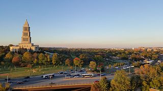
The George Washington Memorial Parkway, colloquially the G.W. Parkway, is a 25-mile-long (40 km) parkway that runs along the south bank of the Potomac River from Mount Vernon, Virginia, northwest to McLean, Virginia, and is maintained by the National Park Service (NPS). It is located almost entirely within Virginia, except for a short portion of the parkway northwest of the Arlington Memorial Bridge that passes over Columbia Island within the District of Columbia.

Hollin Hills is a historic district and neighborhood in southeast Fairfax County, Virginia. It is located primarily in the Fort Hunt area of the county with some portions remaining in the Hybla Valley and Groveton areas since a shift for census purposes prior to 2010. The community contains more than 30 acres (12 ha) of parkland across seven distinct parks, a pool and swim club, a bocce court, and a pickleball and tennis club, operated and maintained by the Civic Association of Hollin Hills (CAHH).
Taylorstown is a small community in Loudoun County, Virginia, built on the banks of Catoctin Creek and the surrounding hillside, about two miles (3 km) south of the Potomac River. First settled in 1734, it holds two of the oldest standing houses in Loudoun County, "Hunting Hill" and "Foxton Cottage", directly across the Catoctin Creek from each other.

Buildings, sites, districts, and objects in Virginia listed on the National Register of Historic Places:

The Northern Virginia trolleys were the network of electric passenger rails that moved people around the Northern Virginia suburbs of Washington, D.C., from 1892 to 1941. They consisted of as many as three separate companies connecting Rosslyn, Great Falls, Bluemont, Mount Vernon, Fairfax City, Camp Humphries and Nauck to Washington, D.C., on six different lines.

Holmes Run Acres is a community of 355 houses in Fairfax County, Virginia, in the Washington, D.C. suburbs. Nearly all of the neighborhood is within the Holmes Run Acres Historic District, listed on the National Register of Historic Places.

Woodlawn is a historic house located in Fairfax County, Virginia. Originally a part of Mount Vernon, George Washington's historic plantation estate, it was subdivided in the 19th century by abolitionists to demonstrate the viability of a free labor system. The address is now 9000 Richmond Highway, Alexandria, Virginia, but due to expansion of Fort Belvoir and reconstruction of historic Route 1, access is via Woodlawn Road slightly south of Jeff Todd Way/State Route 235. The house is a designated National Historic Landmark, primarily for its association with the Washington family, but also for the role it played in the historic preservation movement. It is now a museum property owned and managed by the National Trust for Historic Preservation.

Charles M. Goodman was an American architect who made a name for his modern designs in suburban Washington, D.C. after World War II. While his work has a regional feel, he ignored the colonial revival look so popular in Virginia. Goodman was quoted in the 1968 survey book Architecture in Virginia as saying that he aimed to "get away from straight historical reproduction."

Hollin Hall was an 18th-century plantation house three miles (5 km) southwest of Alexandria in Fairfax County, Virginia. George Mason, a United States Founding Father, gave Hollin Hall to his third son, Thomson Mason, through deeds of gift in 1781 and 1786. The land, as given, totalled 676 acres (2.74 km2). Thomson Mason was the first member of the Mason family to actually live here. Before then, tenants farmed the property.

Delaplane is an unincorporated community in northern Fauquier County, Virginia, approximately 50 miles (80 km) due west of Washington, D.C. Delaplane is situated along U.S. Route 17, U.S. Route 50, and Interstate 66; bordering Upperville, Virginia to the north, Hume, Virginia to the south, Paris, Virginia to the west, and Rectortown, Virginia to the east. Delaplane, Virginia has a ZIP Code of 20144.
Alexandria is an independent city in the northern region of the Commonwealth of Virginia, United States. It lies on the western bank of the Potomac River approximately 7 miles (11 km) south of downtown Washington, D.C. Alexandria is the third-largest "principal city" of the Washington metropolitan area which is part of the larger Washington-Baltimore combined statistical area.

Woodlawn, is a historic slave plantation located at Columbia, Howard County, Maryland. It is a two-story, stuccoed stone house built in 1840 with wood frame portions constructed about 1785. It was part of a 200-acre farm divided from larger parcels patented by the Dorsey family. The design reflects the transition between the Greek Revival and Italianate architecture styles. The home is associated with Henry Howard Owings, a prominent Howard County landowner and farmer, who also served as a judge of the Orphan's Court for Howard County. Owings purchased the property in 1858 and died at Woodlawn in 1869. The former tobacco farm produced corn, oats, hay, and pork. The majority of the property surrounding Woodland and its slave quarters were subdivided by 1966 and purchased by Howard Research and Development for the planned community development Columbia, Maryland, leaving only 5 acres surrounded by multiple lots intended for development of an Oakland Ridge industrial center and equestrian center. The summer kitchen, smokehouse, corn crib and stable built about 1830 have been replaced by a parking lot.

George Washington's Gristmill was part of the original Mount Vernon plantation, constructed during the lifetime of the United States' first president. The original structure was destroyed about 1850. The Commonwealth of Virginia and the Mount Vernon Ladies’ Association have reconstructed the gristmill and the adjacent distillery. The reconstructed buildings are located at their original site three miles (4.8 km) west of the Mount Vernon mansion near Woodlawn Plantation in the Mont Vernon area of Fairfax County. Because the reconstructed buildings embody the distinctive characteristics of late eighteenth century methods of production and are of importance to the history of Virginia, the site is listed on the National Register of Historic Places despite the fact that the buildings are not original.

Hollindale is an unincorporated community in Fort Hunt, Fairfax County, Virginia, United States close to the George Washington Memorial Parkway in ZIP code 22306. As of 2013, it had 945 residents. Mount Vernon Presbyterian Church and Hollin Meadows Elementary School are located within the community. Hollindale is set along the hilly woodlands across from the Potomac. It was built around several estates and on what used to be Sherwood Dairy Farm, and is adjacent to the Hollin Hills community. It is dominated by mid-century modern homes, colonials, and Tudors.
Mount Vernon is a magisterial district in the southeastern sector of Fairfax County, Virginia which encompasses the area along the Potomac River, Mount Vernon, Fort Belvoir, and Gunston Hall. It includes the CDPs of Belle Haven, New Alexandria, Huntington, Groveton, Hybla Valley, Fort Hunt, Mount Vernon, Fort Belvoir, Mason Neck, Lorton, and Newington, Virginia. The office of the district is on 2511 Parkers Lane, Alexandria, VA 22306; Annual Town Meetings are held at Mount Vernon High School's "Little Theatre". As of 2010 the population was 127,637. Dan Storck is the current supervisor.

Paul Eugene Krizek is an American politician. He has served in the Virginia House of Delegates since 2016, representing the 44th district of Virginia in Fairfax County. Krizek is a member of the Democratic Party.

Mount Vernon Unitarian Church (MVUC) is a Unitarian Universalist church in the Fort Hunt area of Fairfax County, Virginia and a member of the Unitarian Universalist Association (UUA). It meets on a portion of the historic Hollin Hall estate. It is a long-time "welcoming congregation," which means it is open and affirming to all. The church has a long history of supporting LGBTQ rights and is an active social justice congregation.


