National Register of Historic Places listings in Amherst County, Virginia

Last updated

Location of Amherst County in Virginia Map of Virginia highlighting Amherst County.svg
Location of Amherst County in Virginia

This is a list of the National Register of Historic Places listings in Amherst County, Virginia.

Contents

This is intended to be a complete list of the properties and districts on the National Register of Historic Places in Amherst County, Virginia, United States. The locations of National Register properties and districts for which the latitude and longitude coordinates are included below, may be seen in an online map. [1]

There are 37 properties and districts listed on the National Register in the county. Another property was once listed but has been removed.


    This National Park Service list is complete through NPS recent listings posted February 2, 2024. [2]

Map all coordinates using: OpenStreetMap

Current listings

[3] Name on the Register [4] ImageDate listed [5] Location City or townDescription
1 Amherst Baptist Church May 27, 2021
(#100006575)
190-194 2nd St.
37°34′59″N79°02′54″W / 37.5831°N 79.0482°W / 37.5831; -79.0482 (Amherst Baptist Church)
Amherst
2 Bear Mountain Indian Mission School
Bear Mountain Indian Mission School Bear Mountain Indian Mission School, full front.jpg
Bear Mountain Indian Mission School
February 21, 1997
(#97000152)
Southwestern corner of the junction of Kenmore and Indian Mission Rds.
37°34′22″N79°07′37″W / 37.5728°N 79.1269°W / 37.5728; -79.1269 (Bear Mountain Indian Mission School)
Amherst
3 Brick House
Brick House Brick House Clifford Dec 08.JPG
Brick House
February 1, 2006
(#05001620)
854 Fletcher's Level Rd.
37°38′38″N79°01′17″W / 37.6439°N 79.0214°W / 37.6439; -79.0214 (Brick House)
Clifford
4 Brightwells Mill Complex
Brightwells Mill Complex Brightwells Mill.jpg
Brightwells Mill Complex
August 15, 2016
(#16000527)
586 Brightwells Mill Rd.
37°27′31″N79°02′51″W / 37.4586°N 79.0475°W / 37.4586; -79.0475 (Brightwells Mill Complex)
Madison Heights
5 Clifford-New Glasgow Historic District
Clifford-New Glasgow Historic District The Saddlery at Clifford.jpg
Clifford-New Glasgow Historic District
March 12, 2012
(#12000122)
State Route 151 and Fletchers Level Rd.
37°38′25″N79°01′20″W / 37.640278°N 79.022222°W / 37.640278; -79.022222 (Clifford-New Glasgow Historic District)
Clifford
6 Dameron Cottage February 5, 2024
(#100009241)
462 South Main St.
37°34′41″N79°03′27″W / 37.5781°N 79.0576°W / 37.5781; -79.0576 (Dameron Cottage)
Amherst
7 Dulwich Manor
Dulwich Manor Dulwich Manor entrance.jpg
Dulwich Manor
May 28, 2013
(#13000335)
550 U.S. Route 60
37°34′27″N79°02′30″W / 37.57403°N 79.04167°W / 37.57403; -79.04167 (Dulwich Manor)
Amherst
8 Edge Hill
Edge Hill Edge Hill plantation driveway.jpg
Edge Hill
May 15, 2008
(#08000418)
1380 Edgehill Plantation Rd.
37°30′11″N78°55′33″W / 37.503056°N 78.925833°W / 37.503056; -78.925833 (Edge Hill)
Gladstone
9 Edgewood
Edgewood Edgewood farmhouse on Puppy Creek Road.jpg
Edgewood
March 14, 2008
(#08000200)
591 Puppy Creek Rd.
37°38′38″N79°09′34″W / 37.643750°N 79.159444°W / 37.643750; -79.159444 (Edgewood)
Amherst
10 Edgewood
Edgewood Edgewood 1818 Dec 08.JPG
Edgewood
August 16, 2006
(#06000706)
138 Garland Ave.
37°34′55″N79°03′20″W / 37.581806°N 79.055417°W / 37.581806; -79.055417 (Edgewood)
Amherst
11 El Bethel Methodist Church
El Bethel Methodist Church El Bethel Methodist Church at Allwood.jpg
El Bethel Methodist Church
April 20, 2018
(#100002354)
925 Buffalo Springs Turnpike
37°38′43″N79°13′15″W / 37.645278°N 79.220833°W / 37.645278; -79.220833 (El Bethel Methodist Church)
Amherst
12 Elon Village Library
Elon Village Library Elon Village Library.jpg
Elon Village Library
November 22, 2016
(#16000793)
Corner of Camden and Younger Drs.
37°30′50″N79°11′40″W / 37.513889°N 79.194444°W / 37.513889; -79.194444 (Elon Village Library)
Amherst
13 Emmanuel Baptist Church
Emmanuel Baptist Church Emmanuel Baptist Church at Sandidges.jpg
Emmanuel Baptist Church
April 27, 2018
(#100002391)
205 Sandidges Rd.
37°39′44″N79°08′45″W / 37.662361°N 79.145833°W / 37.662361; -79.145833 (Emmanuel Baptist Church)
Amherst
14 Fairview
Fairview Fairview on Lowesville Road.jpg
Fairview
June 3, 2009
(#09000391)
2416 Lowesville Rd.
37°41′58″N79°03′56″W / 37.699444°N 79.065556°W / 37.699444; -79.065556 (Fairview)
Amherst
15 Forest Hill
Forest Hill Forest Hill with the Blue Ridge behind.jpg
Forest Hill
March 22, 2007
(#07000218)
713 Indian Creek Rd.
37°42′26″N79°05′04″W / 37.707222°N 79.084444°W / 37.707222; -79.084444 (Forest Hill)
Amherst
16 Fort Riverview (44AH91 and 44AH195)
Fort Riverview (44AH91 and 44AH195) Fort Riverview from southeast.jpg
Fort Riverview (44AH91 and 44AH195)
November 16, 1989
(#89001921)
Hilltop above the James River [6]
37°23′45″N79°03′55″W / 37.395833°N 79.065278°W / 37.395833; -79.065278 (Fort Riverview (44AH91 and 44AH195))
Madison Heights
17 Galt's Mill Complex
Galt's Mill Complex GALT'S MILL COMPLEX, AMHERST COUNTY, VA.jpg
Galt's Mill Complex
September 30, 2009
(#09000791)
1133 Galt's Mill Rd.
37°26′49″N79°00′39″W / 37.446944°N 79.010833°W / 37.446944; -79.010833 (Galt's Mill Complex)
Madison Heights
18 Geddes
Geddes Geddes farmhouse from the road.jpg
Geddes
February 24, 1983
(#83003257)
Jefferson Trace
37°40′01″N78°59′14″W / 37.666944°N 78.987222°W / 37.666944; -78.987222 (Geddes)
Clifford
19 The Glebe
The Glebe The Glebe south of Clifford.jpg
The Glebe
May 15, 2008
(#08000419)
156 State Route 151
37°37′23″N79°00′50″W / 37.623056°N 79.013899°W / 37.623056; -79.013899 (The Glebe)
Amherst
20 Hanshill
Hanshill Hanshill entrance.jpg
Hanshill
September 29, 2011
(#11000715)
142 Leftwich Rd.
37°28′18″N79°09′15″W / 37.471667°N 79.154167°W / 37.471667; -79.154167 (Hanshill)
Madison Heights
21 Hite Store
Hite Store Hite Store at Lowesville.jpg
Hite Store
June 6, 1997
(#97000487)
0.25 miles (0.40 km) south of the junction of Woodson and Lowesville Rds.
37°43′06″N79°04′01″W / 37.718472°N 79.066944°W / 37.718472; -79.066944 (Hite Store)
Lowesville
22 Kenmore Farm
Kenmore Farm Kenmore Farmhouse.jpg
Kenmore Farm
February 17, 2015
(#15000012)
369 Kenmore Rd.
37°35′08″N79°04′12″W / 37.585556°N 79.070000°W / 37.585556; -79.070000 (Kenmore Farm)
Amherst
23 Macedonia Methodist Church
Macedonia Methodist Church Macedonia Methodist Church on Coffeytown Road.jpg
Macedonia Methodist Church
February 8, 2012
(#12000017)
1408 Coffeytown Rd.
37°46′20″N79°13′39″W / 37.772361°N 79.227500°W / 37.772361; -79.227500 (Macedonia Methodist Church)
Vesuvius
24 Madison Heights Elementary School
Madison Heights Elementary School Madison Heights Elementary School.jpg
Madison Heights Elementary School
April 2, 2019
(#100003601)
123 Phelps Rd.
37°25′52″N79°07′21″W / 37.431111°N 79.122500°W / 37.431111; -79.122500 (Madison Heights Elementary School)
Madison Heights
25 Mountain View Farm
Mountain View Farm Rebec Vineyards farmhouse.jpg
Mountain View Farm
September 3, 1997
(#96001453)
2229 N. U.S. Route 29
37°38′29″N78°59′08″W / 37.641389°N 78.985556°W / 37.641389; -78.985556 (Mountain View Farm)
Clifford
26 Norfolk Southern Six Mile Bridge No. 58
Norfolk Southern Six Mile Bridge No. 58 Norfolk Southern Six Mile Bridge No. 58.jpg
Norfolk Southern Six Mile Bridge No. 58
October 12, 1995
(#95001175)
Over the James River west of the junction of Mt. Athos Rd. and the Norfolk Southern Railroad tracks
37°23′35″N79°03′46″W / 37.393056°N 79.062778°W / 37.393056; -79.062778 (Norfolk Southern Six Mile Bridge No. 58)
Lynchburg
27 Oak Lawn
Oak Lawn Oak Lawn.JPG
Oak Lawn
September 6, 2006
(#06000802)
155 Winridge Dr.
37°29′03″N79°08′59″W / 37.484167°N 79.149722°W / 37.484167; -79.149722 (Oak Lawn)
Madison Heights
28 Royster C. Parr House November 16, 2021
(#100007185)
156 Parrtown Rd.
37°40′47″N79°04′34″W / 37.6797°N 79.0760°W / 37.6797; -79.0760 (Royster C. Parr House)
Amherst vicinity
29 Red Hill Farm
Red Hill Farm Driveway to Red Hill Farm near Pedlar Mills.jpg
Red Hill Farm
June 9, 1980
(#80004168)
West of Pedlar Mills on Minors Branch Rd.
37°33′28″N79°15′53″W / 37.557778°N 79.264722°W / 37.557778; -79.264722 (Red Hill Farm)
Pedlar Mills
30 St. Luke's Episcopal Church
St. Luke's Episcopal Church Pedlar Mills church.jpg
St. Luke's Episcopal Church
November 24, 2017
(#100001849)
3788 Buffalo Springs Turnpike
37°33′32″N79°15′17″W / 37.558889°N 79.254722°W / 37.558889; -79.254722 (St. Luke's Episcopal Church)
Pedlar Mills
31 Scott Zion Baptist Church March 23, 2022
(#100007568)
2602 Galts Mill Rd.
37°26′43″N79°04′04″W / 37.4454°N 79.0677°W / 37.4454; -79.0677 (Scott Zion Baptist Church)
Madison Heights
32 Speed the Plough
Speed the Plough Speed the Plough in Amherst County.jpg
Speed the Plough
April 30, 2007
(#07000391)
389 Fair Lea Ln.
37°32′00″N79°11′28″W / 37.533333°N 79.191250°W / 37.533333; -79.191250 (Speed the Plough)
Monroe
33 Sweet Briar College Historic District
Sweet Briar College Historic District Benedict Hall.jpg
Sweet Briar College Historic District
March 30, 1995
(#95000240)
Sweet Briar Dr., 0.5 miles west of U.S. Route 29
37°33′14″N79°04′48″W / 37.553889°N 79.08°W / 37.553889; -79.08 (Sweet Briar College Historic District)
Sweet Briar
34 Sweet Briar House
Sweet Briar House SWEET BRIAR HOUSE.jpg
Sweet Briar House
September 15, 1970
(#70000783)
Southwest of the junction of U.S. Route 29 and Sweet Briar Rd.
37°33′27″N79°04′58″W / 37.557500°N 79.082778°W / 37.557500; -79.082778 (Sweet Briar House)
Sweet Briar
35 Thompson's Mill-Amherst Mill Complex
Thompson's Mill-Amherst Mill Complex Thompson's Mill at Amherst.jpg
Thompson's Mill-Amherst Mill Complex
March 5, 2019
(#100003484)
138-140 Union Hill Rd.
37°34′36″N79°02′55″W / 37.576667°N 79.048611°W / 37.576667; -79.048611 (Thompson's Mill-Amherst Mill Complex)
Amherst
36 Tusculum
Tusculum Tusculum rear driveway.jpg
Tusculum
November 19, 2004
(#04001244)
2077 N. U.S. Route 29
37°38′10″N78°59′51″W / 37.636111°N 78.997500°W / 37.636111; -78.997500 (Tusculum)
Amherst
37 Winton
Winton Winton Dec 08.JPG
Winton
May 2, 1974
(#74002104)
West of State Route 151
37°38′17″N79°01′27″W / 37.638056°N 79.0241667°W / 37.638056; -79.0241667 (Winton)
Clifford

Former listing

[3] Name on the RegisterImageDate listedDate removedLocationCity or townDescription
1 Athlone September 24, 1992
(#92001029)
March 19, 2001Junction of VA 151 and VA 674
Amherst Destroyed by fire

See also

Related Research Articles

<span class="mw-page-title-main">National Register of Historic Places listings in Alleghany County, Virginia</span>

This is a list of the National Register of Historic Places listings in Alleghany County, Virginia.

<span class="mw-page-title-main">National Register of Historic Places listings in Amelia County, Virginia</span>

This is a list of the National Register of Historic Places listings in Amelia County, Virginia.

<span class="mw-page-title-main">National Register of Historic Places listings in Bedford County, Virginia</span>

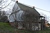
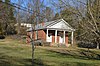
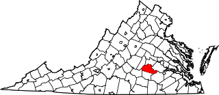
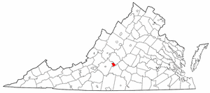
This is a list of the National Register of Historic Places listings in Bedford County, Virginia.

<span class="mw-page-title-main">National Register of Historic Places listings in Prince George County, Virginia</span>

This is a list of the National Register of Historic Places listings in Prince George County, Virginia.

<span class="mw-page-title-main">National Register of Historic Places listings in Lynchburg, Virginia</span>

This is a list of the National Register of Historic Places listings in Lynchburg, Virginia.

<span class="mw-page-title-main">National Register of Historic Places listings in Clarke County, Virginia</span>

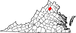
This is a list of the National Register of Historic Places listings in Clarke County, Virginia.

<span class="mw-page-title-main">National Register of Historic Places listings in Isle of Wight County, Virginia</span>

This is a list of the National Register of Historic Places listings in Isle of Wight County, Virginia.

<span class="mw-page-title-main">National Register of Historic Places listings in Winchester, Virginia</span>

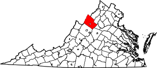
This is a list of the National Register of Historic Places listings in Winchester, Virginia.

<span class="mw-page-title-main">National Register of Historic Places listings in Rockingham County, Virginia</span>

This is a list of the National Register of Historic Places listings in Rockingham County, Virginia.

<span class="mw-page-title-main">National Register of Historic Places listings in Lancaster County, Virginia</span>

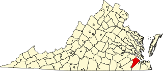
This is a list of the National Register of Historic Places listings in Lancaster County, Virginia.

<span class="mw-page-title-main">National Register of Historic Places listings in Louisa County, Virginia</span>

This is a list of the National Register of Historic Places listings in Louisa County, Virginia.

<span class="mw-page-title-main">National Register of Historic Places listings in New Kent County, Virginia</span>

This is a list of the National Register of Historic Places listings in New Kent County, Virginia.

<span class="mw-page-title-main">National Register of Historic Places listings in Orange County, Virginia</span>

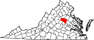
This is a list of the National Register of Historic Places listings in Orange County, Virginia.

<span class="mw-page-title-main">National Register of Historic Places listings in Rappahannock County, Virginia</span>

This is a list of the National Register of Historic Places listings in Rappahannock County, Virginia.

<span class="mw-page-title-main">National Register of Historic Places listings in Shenandoah County, Virginia</span>

This is a list of the National Register of Historic Places listings in Shenandoah County, Virginia.

<span class="mw-page-title-main">National Register of Historic Places listings in Patrick County, Virginia</span>

This is a list of the National Register of Historic Places listings in Patrick County, Virginia.

<span class="mw-page-title-main">National Register of Historic Places listings in Prince Edward County, Virginia</span>

This is a list of the National Register of Historic Places listings in Prince Edward County, Virginia.

<span class="mw-page-title-main">National Register of Historic Places listings in Southampton County, Virginia</span>

This is a list of the National Register of Historic Places listings in Southampton County, Virginia.

<span class="mw-page-title-main">National Register of Historic Places listings in Floyd County, Virginia</span>

This is a list of the National Register of Historic Places listings in Floyd County, Virginia.

<span class="mw-page-title-main">National Register of Historic Places listings in Grayson County, Virginia</span>

This is a list of the National Register of Historic Places listings in Grayson County, Virginia.

References

  1. The latitude and longitude information provided in this table was derived originally from the National Register Information System, which has been found to be fairly accurate for about 99% of listings. Some locations in this table may have been corrected to current GPS standards.
  2. National Park Service, United States Department of the Interior, "National Register of Historic Places: Weekly List Actions", retrieved February 2, 2024.
  3. 1 2 Numbers represent an alphabetical ordering by significant words. Various colorings, defined here, differentiate National Historic Landmarks and historic districts from other NRHP buildings, structures, sites or objects.
  4. "National Register Information System". National Register of Historic Places . National Park Service. April 24, 2008.
  5. The eight-digit number below each date is the number assigned to each location in the National Register Information System database, which can be viewed by clicking the number.
  6. Wittkotksi [sic], J. Mark, and John S. Salmon. National Register of Historic Places Inventory/Nomination: Fort Riverview. National Park Service, 1989-03, 9.