Lowesville, Virginia | |
|---|---|
 A collage of Hite Store (above) and Woodson's Mill (below) in Lowesville. | |
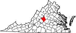
 Lowesville, Virginia Location in Virginia  Lowesville, Virginia Location in the United States | |
| Coordinates: 37°43′09″N79°03′53″W / 37.71917°N 79.06472°W |
Lowesville is an unincorporated community in Nelson County, Virginia, United States. It lies along the path of the now-defunct Virginia Blue Ridge Railway. [1]
Hite Store was added to the National Register of Historic Places in 1997. [2]