Afton, Virginia | |
---|---|
Coordinates: 38°01′56″N78°50′21″W / 38.03222°N 78.83917°W | |
Country | United States |
State | Virginia |
Counties | Albemarle, Nelson |
Elevation | 1,362 ft (415 m) |
Population (2021) | |
• Total | 313 |
Time zone | UTC-5 (Eastern (EST)) |
• Summer (DST) | UTC-4 (EDT) |
ZIP code | 22920 |
Area code | 540 |
FIPS code | 51-00484 |
GNIS feature ID | 1499043 |
[2] |
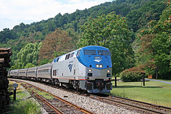
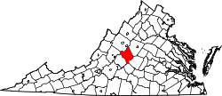
Afton is an unincorporated community and census-designated place in Albemarle and Nelson counties in the Commonwealth of Virginia. It is newly listed as a CDP in the 2020 census with a population of 313. [3]
It is located in the foothills of the Blue Ridge Mountains about 20 miles (32 km) west of Charlottesville. [4]
Afton is home to Hazy Mountain Vineyards & Brewery, Silverback Distillery, Veritas Vineyard and Winery, the Blue Mountain Brewery and Cardinal Point Vineyard & Winery.
Afton first appeared as a census designated place in the 2020 U.S. Census. [5]
Nelson County is a county located in the Commonwealth of Virginia, in the United States. As of the 2020 census, the population was 14,775. Its county seat is Lovingston. Nelson County is part of the Charlottesville, VA, Metropolitan Statistical Area.
Upper Lake is a census-designated place (CDP) in Lake County, California, United States. Upper Lake is located 8 miles (13 km) north of Lakeport, at an elevation of 1,345 feet (410 m). The population was 1,052 at the 2010 census, up from 989 at the 2000 census. The Habematolel Pomo of Upper Lake are headquartered here.
Glen Ellen is a census-designated place (CDP) in Sonoma Valley, Sonoma County, California, United States. The population was 784 at the 2010 census, down from 992 at the 2000 census. Glen Ellen is the location of Jack London State Historic Park, Sonoma Valley Regional Park, and a former home of Hunter S. Thompson.
Crozet is a census-designated place (CDP) in Albemarle County in the Commonwealth of Virginia, United States. It sits along the I-64 corridor, about 12 miles (19 km) west of Charlottesville and 21 miles (34 km) east of Staunton. Crozet is part of the Charlottesville Metropolitan Statistical Area. The population of Crozet was 5,565 at the 2010 census.
Daleville is a census-designated place (CDP) in southern Botetourt County, Virginia, United States. The population was 3,070 at the 2020 census. The CDP is located along U.S. Route 220. It is part of the Roanoke Metropolitan Statistical Area.
Woodlawn is a census-designated place (CDP) in Carroll County, Virginia, United States. The population was 2,045 at the 2020 census.
Mount Vernon is a census-designated place (CDP) and unincorporated community in Fairfax County, Virginia, United States. The population was 12,914 at the 2020 census. Primarily due to its historical significance and natural recreation and beauty, the Mount Vernon area receives over one million tourists each year.
Glen Allen is a census-designated place (CDP) in Henrico County, Virginia, United States. The population was 16,187 as of the 2020 Census, up from 14,774 at the 2010 census. Areas outside the CDP which use a "Glen Allen" mailing address include residences in neighboring Hanover County.
Crab Orchard is a census-designated place (CDP) in Raleigh County, West Virginia, United States. The population was 2,678 at the 2010 census.
Shady Spring is a census-designated place (CDP) in Raleigh County, West Virginia, United States. The population was 2,998 at the 2010 census. It is a residential community, with a low crime rate.
Bealeton is a census-designated place (CDP) in Fauquier County, Virginia, United States, at the intersection of U.S. Route 17 and State Route 28. The population was 5,882 at the 2020 census.
The Blue Ridge Tunnel is a historic railroad tunnel built during the construction of the Blue Ridge Railroad in the 1850s. The tunnel was the westernmost and longest of four tunnels engineered by Claudius Crozet to cross the Blue Ridge Mountains at Rockfish Gap in central Virginia.
Barboursville is an unincorporated community and census-designated place (CDP) in Orange County, Virginia, United States. It is the birthplace of renowned American military commander and president Zachary Taylor. It also contains Barboursville, the home of James Barbour, the 19th governor of the Commonwealth of Virginia, after which the community is named. The ruins of his home are now on land owned by one of the Piedmont region's wineries, Barboursville Vineyards. It was first listed as a CDP in the 2020 census with a population of 177.
Aldie is an unincorporated community and census-designated place (CDP) located between Chantilly and Middleburg in Loudoun County, Virginia, United States. The historic village of Aldie is located on the John Mosby Highway in a gap between the Catoctin Mountains and Bull Run Mountains, through which the Little River flows. Aldie traditionally serves as the gateway to the Loudoun Valley and beyond.
Belmont is a census-designated place (CDP) in Loudoun County, Virginia, United States. The population as of the 2010 United States Census was 5,966. It is 5 miles (8 km) southeast of Leesburg, the Loudoun county seat, and 31 miles (50 km) northwest of Washington, D.C. The Belmont Manor House, built between 1799 and 1802 by a son of Richard Henry Lee, is in the northeast part of the CDP and is now the clubhouse for a gated golf community.
Brucetown is an unincorporated community and census-designated place (CDP) in northern Frederick County, Virginia, United States. It was first listed as a CDP in the 2020 census with a population of 274. Brucetown lies at the intersection of Brucetown and Sir John Roads. A post office was established in the community in 1819. Brucetown also had its own school in operation from 1871 to 1941.
Baywood is an unincorporated community and census-designated place (CDP) in Grayson County, in the southwestern part of the U.S. state of Virginia. It was first listed as a CDP in the 2020 census with a population of 414.
Eagle Rock is a census-designated place (CDP) in Botetourt County, Virginia, United States, located along the James River between Iron Gate and Buchanan. It was first listed as a CDP in the 2020 census with a population of 209.
Brush Fork is a census-designated place (CDP) in Mercer County, West Virginia, United States. Brush Fork is 2 miles (3.2 km) northwest of Bluefield. As of the 2010 census, its population was 1,197.