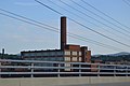
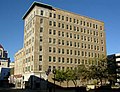
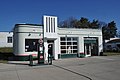
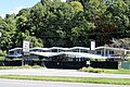
[ 3] Name on the Register [ 4] Image Date listed [ 5] Location Description 1 American Viscose Plant Historic District American Viscose Plant Historic District August 6, 2019 (# 100004260 Roughly 9th St., SE., Industry Ave., SE., River Ave., SE., and Progressive Dr., SE. 37°15′20″N 79°55′20″W / 37.255556°N 79.922222°W / 37.255556; -79.922222 (American Viscose Plant Historic District ) 2 Apartment Building on Windsor Avenue and Brunswick St. Apartment Building on Windsor Avenue and Brunswick St. August 23, 2010 (# 10000559 2049 Windsor Ave., SW. 37°15′47″N 79°58′49″W / 37.263056°N 79.980278°W / 37.263056; -79.980278 (Apartment Building on Windsor Avenue and Brunswick St. ) 3 Belle Aire Belle Aire April 15, 1975 (# 75002034 U.S. Route 11 37°15′49″N 80°01′03″W / 37.263611°N 80.0175°W / 37.263611; -80.0175 (Belle Aire ) 4 Belmont Historic District Belmont Historic District April 15, 2019 (# 100003618 Albemarle, Bullitt, Elm, Jamison, Dale, Campbell, Cedar Bluff, Church, Highland, Mountain, Stewart, Tazewell, and White Aves., SE., and 4th-11th Sts., SE. 37°16′12″N 79°55′45″W / 37.270000°N 79.929167°W / 37.270000; -79.929167 (Belmont Historic District ) 5 Belmont Methodist-Episcopal Church Belmont Methodist-Episcopal Church August 18, 2011 (# 11000551 806 Jamison Ave., SE. 37°16′09″N 79°55′49″W / 37.269167°N 79.930278°W / 37.269167; -79.930278 (Belmont Methodist-Episcopal Church ) 6 Boxley Building Boxley Building March 8, 1984 (# 84003587 416 Jefferson St., SW. 37°16′12″N 79°56′25″W / 37.270000°N 79.940278°W / 37.270000; -79.940278 (Boxley Building ) 7 Boxley-Sprinkle House Boxley-Sprinkle House November 27, 2004 (# 04001275 2611 Crystal Spring Ave. 37°14′39″N 79°57′01″W / 37.244167°N 79.950278°W / 37.244167; -79.950278 (Boxley-Sprinkle House ) 8 Buena Vista Buena Vista July 30, 1974 (# 74002244 Penmar Ave. and 9th St. 37°15′50″N 79°55′23″W / 37.263889°N 79.923056°W / 37.263889; -79.923056 (Buena Vista ) 9 Burrell Memorial Hospital Burrell Memorial Hospital September 22, 2003 (# 03000450 611 McDowell St. 37°16′57″N 79°56′58″W / 37.282500°N 79.949306°W / 37.282500; -79.949306 (Burrell Memorial Hospital ) 10 Campbell Avenue Complex Campbell Avenue Complex January 24, 1991 (# 90002171 118-128 Campbell Ave., SW. 37°16′18″N 79°56′37″W / 37.271667°N 79.943611°W / 37.271667; -79.943611 (Campbell Avenue Complex ) 11 Carlin's Amoco Station Carlin's Amoco Station November 20, 2012 (# 12000968 1721 Williamson Rd., NE. 37°17′17″N 79°56′00″W / 37.288056°N 79.933472°W / 37.288056; -79.933472 (Carlin's Amoco Station ) 12 City of Roanoke Fire Station No. 5 City of Roanoke Fire Station No. 5 November 18, 2011 (# 11000838 216 12th St., NW. 37°16′45″N 79°57′32″W / 37.279167°N 79.958889°W / 37.279167; -79.958889 (City of Roanoke Fire Station No. 5 ) 13 The Coffee Pot The Coffee Pot May 31, 1996 (# 96000575 2902 Brambleton Ave., SW. 37°14′36″N 79°59′28″W / 37.243333°N 79.991111°W / 37.243333; -79.991111 (The Coffee Pot ) 14 Colonial National Bank Colonial National Bank December 17, 1983 (# 83004035 202-208 Jefferson St. 37°16′18″N 79°56′25″W / 37.271667°N 79.940278°W / 37.271667; -79.940278 (Colonial National Bank ) 15 Colony House Motor Lodge Colony House Motor Lodge March 8, 2023 (# 100008648 3560 Franklin Rd. SW 37°14′11″N 79°58′09″W / 37.2364°N 79.9691°W / 37.2364; -79.9691 (Colony House Motor Lodge ) 16 Crystal Spring Steam Pumping Station Crystal Spring Steam Pumping Station May 23, 1980 (# 80004220 2016 Lake St., SE 37°14′59″N 79°56′38″W / 37.249722°N 79.943750°W / 37.249722; -79.943750 (Crystal Spring Steam Pumping Station ) 17 English Gardens Apartments English Gardens Apartments August 17, 2022 (# 100008022 2325, 2331, 2333, 2339, 2343, 2345, 2349 Memorial Ave. SW, 1208, 1218, 1222 Fauquier St. SW, 2324, 2330, 2332, 2336, 2340, 2346, 2352 Denniston Ave. SW 37°16′05″N 79°59′13″W / 37.2680°N 79.9869°W / 37.2680; -79.9869 (English Gardens Apartments ) 18 Fire Station No. 1 Fire Station No. 1 May 7, 1973 (# 73002224 13 E. Church Ave. 37°16′13″N 79°56′24″W / 37.270278°N 79.940000°W / 37.270278; -79.940000 (Fire Station No. 1 ) 19 First National Bank First National Bank June 14, 1982 (# 82004591 101 S. Jefferson St. 37°16′20″N 79°56′27″W / 37.272361°N 79.940833°W / 37.272361; -79.940833 (First National Bank ) 20 Gainsboro Branch of the Roanoke City Public Library Gainsboro Branch of the Roanoke City Public Library December 2, 1996 (# 96001448 15 Patton Ave., NW. 37°16′38″N 79°56′28″W / 37.277222°N 79.941111°W / 37.277222; -79.941111 (Gainsboro Branch of the Roanoke City Public Library ) 21 Gainsboro Historic District Gainsboro Historic District November 16, 2005 (# 05001276 Bounded by Wells, Centre, the First Street Bridge, Gilmer, Commonwealth, N. Jefferson, 2nd., Patton, Harrison, and other streets 37°16′36″N 79°56′40″W / 37.276667°N 79.944444°W / 37.276667; -79.944444 (Gainsboro Historic District ) 22 Grandin Road Commercial Historic District Grandin Road Commercial Historic District November 27, 2002 (# 02001450 Grandin Rd., SW., and Memorial Ave. 37°15′57″N 79°58′37″W / 37.265833°N 79.976944°W / 37.265833; -79.976944 (Grandin Road Commercial Historic District ) 23 Harrison School Harrison School September 9, 1982 (# 82004592 523 Harrison Ave., NW. 37°16′46″N 79°56′53″W / 37.279444°N 79.948056°W / 37.279444; -79.948056 (Harrison School ) 24 Henry Street Historic District Henry Street Historic District November 27, 2004 (# 04001276 100 block of Henry St., NW. 37°16′28″N 79°56′32″W / 37.274444°N 79.942222°W / 37.274444; -79.942222 (Henry Street Historic District ) 25 Patrick Henry Hotel Patrick Henry Hotel July 3, 1991 (# 91000829 617 S. Jefferson St. 37°16′07″N 79°56′27″W / 37.268611°N 79.940833°W / 37.268611; -79.940833 (Patrick Henry Hotel ) 26 Hotel Roanoke Hotel Roanoke February 16, 1996 (# 96000033 110 Shenandoah Ave. 37°16′28″N 79°56′22″W / 37.274444°N 79.939444°W / 37.274444; -79.939444 (Hotel Roanoke ) 27 Huntingdon Huntingdon November 8, 1991 (# 91001598 320 Huntingdon Boulevard 37°18′28″N 79°56′15″W / 37.307778°N 79.937500°W / 37.307778; -79.937500 (Huntingdon ) 28 H. L. Lawson & Son Warehouse H. L. Lawson & Son Warehouse September 5, 2008 (# 08000830 631 Campbell Ave., SE. 37°16′20″N 79°56′00″W / 37.272222°N 79.933333°W / 37.272222; -79.933333 (H. L. Lawson & Son Warehouse ) 29 Lone Oaks Lone Oaks April 11, 1973 (# 73002054 3402 Grandin Rd. Ext., SW. 37°14′57″N 80°00′18″W / 37.249167°N 80.005000°W / 37.249167; -80.005000 (Lone Oaks ) 30 Lucy Addison High School Lucy Addison High School August 12, 2025 (# 100012118 40 Douglass Avenue NW 37°17′00″N 79°56′24″W / 37.2834°N 79.9401°W / 37.2834; -79.9401 (Lucy Addison High School ) 31 Melrose-Rugby Historic District Melrose-Rugby Historic District August 27, 2013 (# 13000645 Mercer, Grayson, and Carroll Aves., NW., Rugby Boulevard, NW., and 10th, 11th, 12th, 13th, and 14th Sts., NW. 37°17′14″N 79°57′16″W / 37.287222°N 79.954444°W / 37.287222; -79.954444 (Melrose-Rugby Historic District ) 32 Monterey Monterey July 30, 1974 (# 74002146 Tinker Creek Lane, NE. 37°18′14″N 79°55′01″W / 37.303889°N 79.916944°W / 37.303889; -79.916944 (Monterey ) 33 Mount Moriah Baptist Church And Cemetery Mount Moriah Baptist Church And Cemetery September 8, 1994 (# 94001092 3521 E. Orange Ave. 37°18′16″N 79°53′27″W / 37.304306°N 79.890833°W / 37.304306; -79.890833 (Mount Moriah Baptist Church And Cemetery ) 34 Mountain View Mountain View October 31, 1980 (# 80004221 714 13th St., SW. 37°16′10″N 79°57′50″W / 37.269444°N 79.963889°W / 37.269444; -79.963889 (Mountain View ) Also known as the Junius Fishburn House 35 Norfolk & Western Class A No. 1218 Locomotive Norfolk & Western Class A No. 1218 Locomotive May 19, 2025 (# 100011843 303 Norfolk Avenue SW 37°16′22″N 79°56′50″W / 37.2729°N 79.9472°W / 37.2729; -79.9472 (Norfolk & Western Class A No. 1218 Locomotive ) 36 Norfolk & Western Class J No. 611 Locomotive Norfolk & Western Class J No. 611 Locomotive February 8, 2024 (# 100009961 303 Norfolk Avenue SW 37°16′22″N 79°56′50″W / 37.2729°N 79.9472°W / 37.2729; -79.9472 (Norfolk & Western Class J No. 611 Locomotive ) 37 Norfolk and Western Railway Company Historic District Norfolk and Western Railway Company Historic District January 27, 1999 (# 99000076 88 and 108 Jefferson St., NW., and 209 Shenandoah Ave. 37°16′26″N 79°56′28″W / 37.273889°N 79.941111°W / 37.273889; -79.941111 (Norfolk and Western Railway Company Historic District ) 38 Norfolk & Western Railway Freight Station Norfolk & Western Railway Freight Station November 21, 2012 (# 12000969 303 Norfolk Ave. 37°16′23″N 79°56′46″W / 37.273056°N 79.946111°W / 37.273056; -79.946111 (Norfolk & Western Railway Freight Station ) Now serves as the location for the Virginia Museum of Transportation 39 Norwich Historic District Norwich Historic District September 17, 2024 (# 100010835 1815-2433 Roanoke Avenue SW, 614-920 Bridge Street SW, Penn Street SW, Russell Avenue SW, Buford Avenue SW, Charlevoix Court SW, Irvine Street SW, Warwick Street SW, Rolfe Street SW, Ashlawn Street SW, and Bedford Street SW 37°16′13″N 79°58′34″W / 37.2704°N 79.9760°W / 37.2704; -79.9760 (Norwich Historic District ) 40 Riverland Historic District Riverland Historic District August 27, 2013 (# 13000646 Laural, Primrose, Whitman, and Ivy Sts., Riverland Rd., and Walnut and Arbutus Aves. 37°15′30″N 79°56′03″W / 37.258333°N 79.934167°W / 37.258333; -79.934167 (Riverland Historic District ) 41 Roanoke Apartments Roanoke Apartments November 9, 2006 (# 06000759 1402 Maiden Lane 37°15′50″N 79°58′07″W / 37.263889°N 79.968611°W / 37.263889; -79.968611 (Roanoke Apartments ) 42 Roanoke City Firehouse No. 6 Roanoke City Firehouse No. 6 January 24, 1991 (# 90002162 1015 Jamison Ave., SE. 37°16′11″N 79°55′34″W / 37.269722°N 79.926111°W / 37.269722; -79.926111 (Roanoke City Firehouse No. 6 ) 43 Roanoke City Health Center Roanoke City Health Center May 12, 2016 (# 16000263 515 8th St., SW. 37°16′14″N 79°57′21″W / 37.270556°N 79.955833°W / 37.270556; -79.955833 (Roanoke City Health Center ) 44 Roanoke City Market Historic District Roanoke City Market Historic District April 20, 1983 (# 83003312 Roughly bounded by Williamson Rd., Norfolk Ave., S. Jefferson St., and Church Ave.; also 302 Campbell Ave., SE., and 9 Church Ave., SE. 37°16′18″N 79°56′21″W / 37.271667°N 79.939167°W / 37.271667; -79.939167 (Roanoke City Market Historic District ) Second set of addresses represents a boundary increase of June 6, 2002 45 Roanoke Downtown Historic District Roanoke Downtown Historic District September 14, 2002 (# 02000978 Roughly bounded by 3rd St., Norfolk Ave., Jefferson St., and Bullitt Ave.; also 310-324 Salem Ave., SW.; also the 300-400 blocks of Church and 300-400 blocks of Luck Aves., SW., 600-700 blocks of S. Jefferson St., and 401 3rd and 502 5th Sts., SW. 37°16′16″N 79°56′33″W / 37.271111°N 79.942500°W / 37.271111; -79.942500 (Roanoke Downtown Historic District ) Second and third sets of boundaries represent boundary increases of March 29, 2007 and August 27, 2013 respectively 46 Roanoke River and Railroad Historic District Roanoke River and Railroad Historic District December 24, 2013 (# 13000994 Albemarle and Walnut Aves., SE., Williamson Rd., SE., and 4th and Jefferson Sts., SE. 37°15′35″N 79°56′20″W / 37.259722°N 79.938889°W / 37.259722; -79.938889 (Roanoke River and Railroad Historic District ) 47 Roanoke Star Roanoke Star November 15, 1999 (# 99001375 Mill Mountain 37°15′03″N 79°55′57″W / 37.250833°N 79.932500°W / 37.250833; -79.932500 (Roanoke Star ) 48 Roanoke Warehouse Historic District Roanoke Warehouse Historic District March 29, 1983 (# 83003313 109-133 Norfolk Ave., SW. 37°16′23″N 79°56′36″W / 37.273056°N 79.943333°W / 37.273056; -79.943333 (Roanoke Warehouse Historic District ) 49 Tayloe Rogers House Tayloe Rogers House November 21, 2012 (# 12000970 1542 Electric Rd., SW. 37°15′25″N 80°02′01″W / 37.256944°N 80.033611°W / 37.256944; -80.033611 (Tayloe Rogers House ) 50 St. Andrew's Roman Catholic Church St. Andrew's Roman Catholic Church May 7, 1973 (# 73002225 631 N. Jefferson St. 37°16′42″N 79°56′24″W / 37.278333°N 79.940000°W / 37.278333; -79.940000 (St. Andrew's Roman Catholic Church ) 51 St. John's Episcopal Church St. John's Episcopal Church August 23, 1991 (# 91001083 Southwestern corner of Jefferson St. and Elm Ave. 37°16′00″N 79°56′28″W / 37.266667°N 79.941111°W / 37.266667; -79.941111 (St. John's Episcopal Church ) 52 Salem Avenue-Roanoke Automotive Commercial Historic District Salem Avenue-Roanoke Automotive Commercial Historic District August 8, 2007 (# 07000807 Generally Salem Ave., Rorer Ave., and Campbell Ave. between 3rd and 6th Sts.; also the 400-600 blocks of Campbell Ave.; also the 700 block of Patterson Ave. 37°16′21″N 79°56′58″W / 37.272500°N 79.949444°W / 37.272500; -79.949444 (Salem Avenue-Roanoke Automotive Commercial Historic District ) Second and third sets of boundaries represent boundary increases of May 15, 2008 and October 22, 2014 respectively 53 Salvation Army Citadel Salvation Army Citadel August 7, 2020 (# 100005429 821 Salem Ave., SW. 37°16′25″N 79°57′23″W / 37.273611°N 79.956394°W / 37.273611; -79.956394 (Salvation Army Citadel ) 54 Southwest Historic District Southwest Historic District June 19, 1985 (# 85001349 Roughly bounded by Salem Ave., Jefferson St., the Roanoke River , and 20th St.; also roughly bounded by Westview, Westport, Salem, Jackson, Norfolk, Rorer, Campbell, Marshall, Day, Jefferson, and Clark Aves., the Roanoke River, and 13th and 21st Sts. 37°16′08″N 79°57′20″W / 37.268889°N 79.955556°W / 37.268889; -79.955556 (Southwest Historic District ) 55 Villa Heights Villa Heights June 4, 2018 (# 100002532 2750 Hoover St. 37°17′33″N 79°58′44″W / 37.292500°N 79.978889°W / 37.292500; -79.978889 (Villa Heights ) 56 Virginia Can Company-S.H. Heironimus Warehouse Virginia Can Company-S.H. Heironimus Warehouse February 22, 2006 (# 06000067 315 Albemarle Ave., SE. 37°15′47″N 79°56′16″W / 37.263056°N 79.937778°W / 37.263056; -79.937778 (Virginia Can Company-S.H. Heironimus Warehouse ) Built beside the Virginian Railway in 1912 to house Roanoke's first tin can company; later a clothing factory and then a department store warehouse [ 6] 57 Virginian Railway Passenger Station Virginian Railway Passenger Station May 22, 2003 (# 03000456 1402 Jefferson St., SE. 37°15′35″N 79°56′28″W / 37.259722°N 79.941111°W / 37.259722; -79.941111 (Virginian Railway Passenger Station ) 58 Wasena Historic District Wasena Historic District January 3, 2012 (# 11000984 Wiley Dr., Winchester, Winona, Wasena, Howbert, Valley, Hamilton, Kerns, Floyd, and Summit Aves., Brighton Rd. 37°15′48″N 79°57′36″W / 37.263333°N 79.960000°W / 37.263333; -79.960000 (Wasena Historic District )