
Roanoke is an independent city in the U.S. state of Virginia. It is located in Southwest Virginia along the Roanoke River, in the Blue Ridge range of the greater Appalachian Mountains, approximately 50 miles (80 km) north of the Virginia–North Carolina border and 250 miles (400 km) southwest of Washington, D.C., along Interstate 81. At the 2020 census, Roanoke's population was 100,011, making it the largest city in Virginia west of the state capital Richmond. It is the principal municipality of the Roanoke metropolitan area, which had a 2020 population of 315,251.
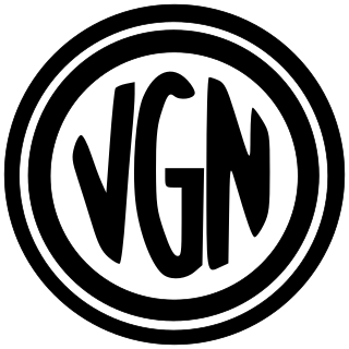
The Virginian Railway was a Class I railroad located in Virginia and West Virginia in the United States. The VGN was created to transport high quality "smokeless" bituminous coal from southern West Virginia to port at Hampton Roads.

Manchester is a former independent city in Virginia in the United States. Prior to receiving independent status, it served as the county seat of Chesterfield County, between 1870 and 1876. Today, it is a part of the city of Richmond, Virginia.

The Western Maryland Railway was an American Class I railroad (1852–1983) that operated in Maryland, West Virginia, and Pennsylvania. It was primarily a coal hauling and freight railroad, with a small passenger train operation.

Broad Street Station was a union railroad station in Richmond, Virginia, United States, across Broad Street from the Fan district. The building is now used by the Science Museum of Virginia.

Rapidan is a small unincorporated community in the Virginia counties of Culpeper and Orange, approximately 5 miles (8 km) northeast of the Town of Orange. The community, located on both sides of the Rapidan River, was established in the late eighteenth century around the Waugh's Ford mill. The Orange and Alexandria Railroad built a line through the town in 1854, a post office was built at the river crossing, and its name was changed to Rapid Ann Station. Milling remained a major industry in the area up through the mid-twentieth century.

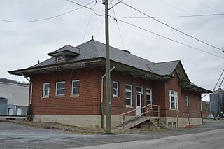
The Virginian Railway Passenger Station, also known as the Virginian Station is a former rail station listed on the National Register of Historic Places in the South Jefferson neighborhood of the independent city of Roanoke, Virginia, U.S.A. Located at the intersection of Jefferson Street SE and Williamson Road, the Virginian Station served as a passenger station for the Virginian Railway between 1910 and 1956. The station was the only station constructed with brick along the entire length of the Virginian's 608 miles (978 km) network. It was severely damaged by fire on January 29, 2001.
The Raleigh and Gaston Railroad was a Raleigh, North Carolina, based railroad opened in April 1840 between Raleigh and the town of Gaston, North Carolina, on the Roanoke River. It was North Carolina's second railroad. The length was 100 miles (160 km) and built with 4 ft 8 in gauge. Part of the Raleigh and Gaston's tracks remains in service today as part of CSX's S Line as the Norlina Subdivision of CSX's Florence Division.
Downtown is the central business district of Roanoke, Virginia, United States. Located geographically at the center of the city, Downtown began its development with the completion of the Shenandoah Valley Railroad in 1882. Today the Downtown core is noted as the center of business for the Roanoke Valley and Southwest Virginia, the Roanoke City Market, the Roanoke Downtown Historic District and many other attractions and amenities.
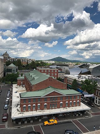
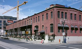
Roanoke City Market Historic District, also known as City Market District, is a national historic district located in the Downtown Roanoke area of Roanoke, Virginia.

Pocahontas Island is a peninsula in Petersburg, Virginia once on the opposite side of the Appomattox River from Petersburg. Since 1915 a new channel for the river separated it from Chesterfield County and the former channel no longer separates it from the city. Once a warehouse and wharf-filled urban landscape initially platted in 1749, the island was devastated by a 1993 tornado before citizen involvement caused creation of the Pocahontas Island Historic District, which in 2006 achieved listing on the National Register of Historic Places (NRHP) as a historic district because of its significance in African-American history and for its prehistoric indigenous archeological assets.

The Hinton Historic District is a national historic district located at Hinton, Summers County, West Virginia. The original Hinton Historic District is bordered roughly by the Chesapeake and Ohio Railroad line, James Street, 5th Avenue, and Roundhouse. The boundary increase extended the district to include Mill Street. It was listed on the National Register of Historic Places in 1984 and revised in 2005.

Petersburg Union Station is a former train station in Petersburg, Virginia. It was built in 1909–1910 for the Norfolk and Western Railway, and was later used by the Atlantic Coast Line Railroad and Amtrak.

Croton North station is a disused train station on Senasqua Road in Croton-on-Hudson, New York, United States. It was built by the New York Central Railroad in the late 19th century. In 1987 it was listed on the National Register of Historic Places as Croton North Railroad Station.
The North Bank Depot Buildings, in central Portland, Oregon, United States, are a pair of buildings formerly used as a freight warehouse and passenger terminal for the Spokane, Portland and Seattle Railway (SP&S). Formed in 1905, the SP&S was commonly known as the North Bank Road during the period in which these buildings were in use. The Portland buildings' passenger facilities were also used by the Oregon Electric Railway after that railway was acquired by the SP&S. Located in what is now known as the Pearl District, the buildings were listed on the National Register of Historic Places in 1996. They were in use by the SP&S and its successor, Burlington Northern Railroad, from 1908 until the 1980s. Only the east building was used as a passenger station, and this usage lasted from 1908 until 1931.

Metolius station, also known as the Oregon Trunk Passenger and Freight Station is a historic railway station located on Washington Street at the foot of Sixth Street in Metolius, Oregon. The station was built in 1911 to serve passenger and freight traffic along the Oregon Trunk Railway, which provided a railway connection for towns in central Oregon. The station building has a Stick Style design and was built to a standard station plan used by the line. As the railroad entered a canyon on the Deschutes River near Metolius, it became an important station on the line, as its railway yard housed the pusher locomotives needed to help trains out of the canyon. The railway opened up previously inaccessible land to homesteaders; some of these homesteaders settled in the Metolius area, while others traveled further down the line to Redmond and Bend. The station closed in 1983; by then it served the Burlington Northern Railroad, which sold the building to the city of Metolius the next year.

Norfolk and Western Railway Company Historic District is a national historic district located in Roanoke, Virginia. It encompasses three contributing buildings constructed by the Norfolk and Western Railway (N&W). They are the Neoclassical Revival style General Office Building–South ; the Art Deco period General Office Building–North (1931); and the Moderne style Passenger Station.
The Newington Railroad Depot is a historic railroad station on Bloody Point Road in Newington, New Hampshire. Built in 1873, it is an unusual railroad-related structure, serving as a passenger and freight depot, and as the residence of the stationmaster, who also performed the role of toll collector for the nearby bridge. It is the only surviving 19th-century railroad-related structure in Newington. Now vacant and owned by the state, the building was listed on the National Register of Historic Places in 2010.
The Tazewell Depot is a historic railroad station at 135 Railroad Avenue in Tazewell, Virginia. It is a long rectangular brick structure, one story in height, with a hip roof that has broad eaves supported by large brackets. Both the long street-facing and track-facing sides have projecting bay sections. The depot was built in 1928 by the Norfolk and Western Railway to serve passenger traffic on its line; the substantial freight volume was handled by a larger adjacent frame building. Passenger service ended about 1957, after which time the depot was also used for freight traffic, which was finally ended in 1974. It is one of two surviving depots that served on the Clinch River Line.

The Chicago, Milwaukee & St. Paul Depot-Jefferson, also known simply as the Milwaukee Depot is an historic building located in Jefferson, Iowa, United States. The rail line that this station served was built by the Wabash, St. Louis and Pacific Railway in either 1882 or 1883. It was part of the 500 miles (800 km) of track developed by Jay Gould in Iowa. Known as the High Bridge Route because of the height of the bridge over the Des Moines River, it was acquired by the Des Moines, Northern and Western Railroad in 1891. Four years later the Chicago, Milwaukee and St. Paul Railway acquired the line. The Milwaukee Road built this train station from their standard building plan between 1906 and 1909. It is almost identical to the station built in 1906 in Adel, Iowa. This passenger station replaced a combination passenger and freight depot that was moved and used solely as a freight depot. The Milwaukee Road discontinued passenger service in Jefferson in the early 1950s, and the depot continued as a freight office until 1980. The building was listed on the National Register of Historic Places in 1994.


