
Lewis County is a county in the U.S. state of Washington. As of the 2020 census, the county's population was 82,149. The county seat is Chehalis, and its largest city is Centralia. Lewis County comprises the Centralia, WA Micropolitan Statistical Area, which is also included in the Seattle-Tacoma, WA Combined Statistical Area.

A National Historic Landmark (NHL) is a building, district, object, site, or structure that is officially recognized by the United States government for its outstanding historical significance. Only some 2,500, or roughly three percent, of over 90,000 places listed on the country's National Register of Historic Places are recognized as National Historic Landmarks.

The Lewis and Clark National Historical Park, located in the vicinity of the mouth of the Columbia River, commemorates the Lewis and Clark Expedition. Administration of the park, which includes both federal and state lands, is a cooperative effort of the National Park Service and the states of Oregon and Washington. The National Historical Park was dedicated on November 12, 2004.

Rooster Rock State Park is a state park located east of Corbett, in the U.S. state of Oregon. One of the features of the park is Rooster Rock, a column of basalt forming a natural obelisk, which stands near the south side of the Columbia River Gorge, in the lee of Crown Point. The park is administered by the Oregon Parks and Recreation Department.

The Lewis and Clark National Historic Trail is a route across the United States commemorating the Lewis and Clark Expedition of 1804 to 1806. It is part of the National Trails System of the United States. It extends for some 4,900 miles (7,900 km) from Pittsburgh, Pennsylvania, to the mouth of the Columbia River in Oregon.

Cape Disappointment State Park is a public recreation area on Cape Disappointment, located southwest of Ilwaco, Washington, on the bottom end of Long Beach Peninsula, the northern headlands where the Columbia River meets the Pacific Ocean. The state park's 2,023 acres (819 ha) encompass a diverse landscape of old-growth forest, freshwater lakes, freshwater and saltwater marshes, and oceanside tidelands. Park sites include Fort Canby, the Lewis and Clark Interpretive Center, North Head Lighthouse, and Cape Disappointment Lighthouse. Cape Disappointment is one of several state parks and sites in Washington and Oregon that are included in Lewis and Clark National Historical Park.

The Long Beach Peninsula is an arm of land on the southern coast of the state of Washington in the United States. Entirely within Pacific County, it is bounded on the west by the Pacific Ocean, the south by the Columbia River, and the east by Willapa Bay. Leadbetter Point State Park and Willapa National Wildlife Refuge are at the northern end of the peninsula and Cape Disappointment is at the southern end, with Pacific Pines State Park located in between.
This is a list of properties and historic districts in Washington that are listed on the National Register of Historic Places. There are at least three listings in each of Washington's 39 counties.
Georgia's 5th congressional district is a congressional district in the U.S. state of Georgia. The district was represented by Democrat John Lewis from January 3, 1987, until his death on July 17, 2020. Kwanza Hall was elected to replace Lewis on December 1, 2020, and served until January 3, 2021, when Nikema Williams took his place. Hall was elected in a special election for the balance of Lewis' 17th term. He chose not to run in the general election for a full two-year term, which was won by Williams.

The Lewis Range is a mountain range located in the Rocky Mountains of northern Montana, United States and extreme southern Alberta, Canada. It was formed as a result of the Lewis Overthrust, a geologic thrust fault resulted in the overlying of younger Cretaceous rocks by older Proterozoic rocks. The range is located within Waterton Lakes National Park in Alberta, Canada and Glacier National Park and the Bob Marshall Wilderness Complex in Montana, United States. The highest peak is Mount Cleveland at 10,479 ft (3,194 m).

Samuel S. Lewis State Park is an 85-acre (34 ha) Pennsylvania state park in Lower Windsor Township, York County, Pennsylvania, in the United States. Mt. Pisgah is an 885-foot-high (270 m) ridge that is the focus of recreation for the park. The ridge separates East Prospect Valley from Kreutz Creek Valley. An overlook on Mt. Pisgah gives visitors a view of the Susquehanna River Valley. Samuel S. Lewis Park is twelve miles (19 km) east of York near U.S. Highway 30.

Lewis and Clark State Recreation Site is a state park in eastern Multnomah County, Oregon, near Troutdale and Corbett, and is administered by the Oregon Parks and Recreation Department. It is located on the Sandy River, near its confluence with the Columbia River. Broughton's Bluff marks the westernmost extent of the Columbia River Gorge at the site.

Lewis and Clark State Park is a public recreation area occupying 189 acres (76 ha) on the south shore of 365-acre (148 ha) Lewis and Clark Lake in Buchanan County, Missouri. The state park features camping, picnicking, and fishing.

This is a list of the National Register of Historic Places listings in Lewis County, West Virginia.

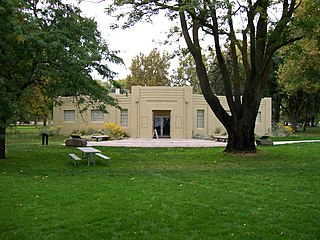
Lewis and Clark State Park is a public recreation area located six miles (9.7 km) northeast of Winlock and immediately south of Mary's Corner in Lewis County, Washington. Named after the explorers Lewis and Clark, despite the expedition not venturing in the area during their travels, the state park occupies one of the last major stands of old-growth forest in the state. When the park opened in the 1920s it was visited by over 10,000 people per year.
Lewis and Clark Trail State Park is a 36-acre (15 ha) Washington state park located on the Touchet River in Columbia County with both old-growth forest and 1,333 feet (406 m) of river shoreline. The park offers camping, hiking, fishing, swimming, birdwatching, interpretive activities, wildlife viewing, and athletic fields.
Sacajawea State Park is a public recreation area and historical preserve in the city of Pasco, Washington, covering 267 acres (108 ha) at the confluence of the Snake and Columbia rivers where the Lewis and Clark Expedition camped on October 16, 1805. The state park bears the name of the Shoshone woman Sacagawea, who was an active member of the expedition married to expedition member Toussaint Charbonneau, a French-Canadian interpreter and explorer. The park's Sacajawea Interpretive Center features exhibits about her and about the Lewis and Clark Expedition.

This is a list of the National Register of Historic Places listings in Lewis County, Missouri.

Sacajawea and Jean-Baptiste is a bronze sculpture of Sacagawea and Jean Baptiste Charbonneau by American artist Alice Cooper, located in Washington Park in Portland, Oregon, in the United States.

Lewis and Clark State Park is a state park in the US state of Iowa consisting of 176 acres (71 ha) located in Monona County. The park features camping, picnicking, boating, swimming, and fishing on 250-acre (100 ha) Blue Lake. It has 95 electric camp sites and has a full size replica of a keelboat of the type used by the Lewis and Clark Expedition when they stopped in this area in 1804 on their way up the Missouri River.


