
The Potomac River is a major river in the Mid-Atlantic region of the United States that flows from the Potomac Highlands in West Virginia to the Chesapeake Bay in Maryland. It is 405 miles (652 km) long, with a drainage area of 14,700 square miles (38,000 km2), and is the fourth-largest river along the East Coast of the United States and the 21st-largest in the United States. More than 5 million people live within its watershed.

Great Falls is a census-designated place in Fairfax County, Virginia, United States. The population at the 2020 census was 15,953.

Paw Paw is a town in Morgan County, West Virginia, United States. The population was 410 at the 2020 census. The town is known for the nearby Paw Paw Tunnel. Paw Paw was incorporated by the Circuit Court of Morgan County on April 8, 1891, and named after pawpaw, a wild fruit that grows in abundance throughout this region. Paw Paw is the westernmost incorporated community in Morgan County, and the Hagerstown-Martinsburg, MD-WV Metropolitan Statistical Area.

The Chesapeake and Ohio Canal, abbreviated as the C&O Canal and occasionally called the Grand Old Ditch, operated from 1831 until 1924 along the Potomac River between Washington, D.C. and Cumberland, Maryland. It replaced the Potomac Canal, which shut down completely in 1828, and could operate during months in which the water level was too low for the former canal. The canal's principal cargo was coal from the Allegheny Mountains.
The Potomac Company was created in 1785 to make improvements to the Potomac River and improve its navigability for commerce. The project is perhaps the first conceptual seed planted in the minds of the new American capitalists in what became a flurry of transportation infrastructure projects, most privately funded, that drove wagon road turnpikes, navigations, and canals, and then as the technology developed, investment funds for railroads across the rough country of the Appalachian Mountains.

Theodore Roosevelt Island is an 88.5-acre (358,000 m2) island and national memorial located in the Potomac River in Washington, D.C. During the Civil War, it was used as a training camp for the United States Colored Troops. The island was given to the federal government by the Theodore Roosevelt Association in memory of the 26th president, Theodore Roosevelt. Until then, the island had been known as My Lord's Island, Barbadoes Island, Mason's Island, Analostan Island, and Anacostine Island.

The Patowmack Canal, sometimes called the Potomac Canal, is a series of five inoperative canals located in Maryland and Virginia, United States, that was designed to bypass rapids in the Potomac River upstream of the present Washington, D.C., area. The most well known of them is the Great Falls skirting canal, whose remains are managed by the National Park Service since it is within Great Falls Park, an integral part of the George Washington Memorial Parkway.

The George Washington Memorial Parkway, colloquially the G.W. Parkway, is a 25-mile-long (40 km) limited-access parkway that runs along the south bank of the Potomac River from Mount Vernon, Virginia, northwest to McLean, Virginia, and is maintained by the National Park Service (NPS). It is located almost entirely in Northern Virginia, except for a short portion of the parkway northwest of the Arlington Memorial Bridge that passes over Columbia Island in Washington, D.C.

The James River and Kanawha Canal was a partially built canal in Virginia intended to facilitate shipments of passengers and freight by water between the western counties of Virginia and the coast. Ultimately its towpath became the roadbed for a rail line following the same course.

Great Falls Park is a small National Park Service (NPS) site in Virginia, United States. Situated on 800 acres (3.2 km2) along the banks of the Potomac River in northern Fairfax County, the park is a disconnected but integral part of the George Washington Memorial Parkway. The Great Falls of the Potomac River are near the northern boundary of the park, as are the remains of the Patowmack Canal, the first canal in the United States that used locks to raise and lower boats.
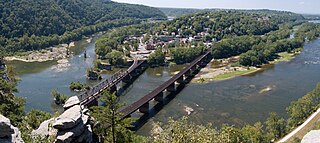
Harpers Ferry National Historical Park, originally Harpers Ferry National Monument, is located at the confluence of the Potomac and Shenandoah rivers in and around Harpers Ferry, West Virginia. The park includes the historic center of Harpers Ferry, notable as a key 19th-century industrial area and as the scene of John Brown's failed abolitionist uprising. It contains the most visited historic site in the state of West Virginia, John Brown's Fort.

Great Falls is a series of rapids and waterfalls on the Potomac River, 14 miles (23 km) upstream from Washington, D.C., on the border of Montgomery County, Maryland and Fairfax County, Virginia. The Potomac and the falls themselves are legally entirely within Maryland, since the state's border follows the south bank of the river.

Difficult Run is a 15.9-mile-long (25.6 km) tributary stream of the Potomac River in Northern Virginia in the United States. The area has had many historical uses dating back to the early 1800s. Today, the area is used recreationally by visitors interested in the watershed's variety of options including hiking, biking, fishing, boating, climbing, and bird watching. The wildlife at Difficult Run is vast as 163 different species can be seen depending on the season. There are 41 different soil types found on the trail and alongside the stream. The stream is part of the greater 57.7- square-mile Drainage basin, or watershed, located in the north-central portion of Fairfax County, Virginia and drains directly to the Potomac River.
Leven Powell was a Virginia planter, merchant, Continental Army officer and Federalist politician who served several terms in the Virginia House of Delegates as well as in the Virginia Ratification Convention representing Loudoun County, and one term as a United States representative for Virginia's 17th congressional district.

The Mount Vernon Conference was a meeting of delegates from Virginia and Maryland held at Mount Vernon on March 21–28, 1785, to discuss navigational rights in the states' common waterways. On March 28, 1785, the group drew up a thirteen-point proposal to govern the rights of both states on the Potomac River, Pocomoke River, and Chesapeake Bay. Known as the Mount Vernon Compact and formally titled as the Compact of 1785, this agreement not only covered tidewater navigation but also extended to issues such as toll duties, commerce regulations, fishing rights, and debt collection. Ratified by the legislature of both states, the compact helped set a precedent for later meetings between states for discussions into areas of mutual concern.
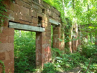
Seneca Quarry is a historic site located at Seneca, Montgomery County, Maryland. It is located along the Chesapeake and Ohio Canal on the north bank of the Potomac River, just west of Seneca Creek. The quarry was the source of stone for two Potomac River canals: the Patowmack Canal on the Virginia side of Great Falls; and the C&O Canal, having supplied red sandstone for the latter for locks 9, 11, 15 - 27, and 30, the accompanying lock houses, and Aqueduct No. 1, better known as Seneca Aqueduct, constructed from 1828 to 1833.
Falls Church, an independent city in Virginia, United States, takes its name from The Falls Church, an 18th-century parish of the Church of England. Falls Church gained township status within Fairfax County in 1875. In 1948, it was incorporated as the City of Falls Church, an independent city with county-level governance status.

A series of projects in the 18th and 19th centuries attempted to make the Potomac River navigable and connect the Ohio River valley and the East Coast. The first project was started by the Potomac Company, but it was the Chesapeake and Ohio Canal Company (C&O) that finished the project in the 1830s and 1840s.
The following is a timeline of the history of the census-designated place (CDP) of Great Falls, Virginia, USA.
Josiah Clapham was a colonial merchant, military officer, and politician in Virginia who served as a member of the House of Burgesses and later the Virginia General Assembly, representing Loudoun County.


