Chantilly, Virginia

Last updated

Chantilly
2019-07-22 15 59 39 View east along U.S. Route 50 (Lee Jackson Memorial Highway) at Sullyfield Circle, Centerview Drive, Centreville and Walney Roads in Chantilly, Virginia, viewed from a plane heading for Washington Dulles International Airport.jpg
Central Chantilly
Fairfax County Virginia Incorporated and Unincorporated Areas Chantilly highlighted.svg
Location of Chantilly in Fairfax County, Virginia
USA Virginia Northern location map.svg
Red pog.svg
Chantilly
USA Virginia location map.svg
Red pog.svg
Chantilly
Usa edcp location map.svg
Red pog.svg
Chantilly
Coordinates: 38°52′30″N77°24′9″W / 38.87500°N 77.40250°W / 38.87500; -77.40250
CountryUnited States
State Virginia
County Fairfax
Area
  Total12.12 sq mi (31.40 km2)
  Land12.00 sq mi (31.09 km2)
  Water0.12 sq mi (0.32 km2)
Elevation
322 ft (98 m)
Population
 (2020) [1]
  Total24,301
  Density2,024/sq mi (781.6/km2)
Time zone UTC−5 (Eastern)
  Summer (DST) UTC−4 (Eastern)
ZIP Codes
20151–20153
Area code(s) 703, 571
FIPS code 51-14744 [2]
GNIS feature ID1495375 [3]

Chantilly is a census-designated place (CDP) in western Fairfax County, Virginia. [4] [5] The population was 24,301 as of the 2020 census. [1] Chantilly is named after an early-19th-century mansion and farm, which in turn took the name of an 18th-century plantation that was located in Westmoreland County, Virginia. [6] The name "Chantilly" originated in France with the Château de Chantilly, [7] [6] about 28 miles north of Paris.

Contents

Located in the Northern Virginia portion of the Washington metropolitan area, Chantilly sits approximately 25 miles (40 km) west of Washington, D.C., via Interstate 66 and U.S. Route 50. It is located between Centreville to the south, Herndon and Reston to the north and northeast, respectively, and Fairfax 7 miles (11 km) to the southeast. U.S. Route 50 and Virginia State Route 28 intersect in Chantilly, and these highways provide access to the Dulles/Reston/Tysons Corner technology corridor and other major employment centers in Northern Virginia and Washington, D.C.

History

Chantilly was home to a number of colonial plantations in the 1700s, including the Sully Plantation (now the Sully Historic Site) built by Richard Bland Lee I. Other plantations included George Richard Lee Turberville's "Leeton Grove" [8] (originally a 5,000+ acre plantation, the main house of which still stands at 4619 Walney Rd.), the John Hutchison Farm, and the Chantilly Plantation, after which Chantilly is named. Cornelia Lee Turberville Stuart, who was born at Leeton and was the daughter of George Richard Lee Turberville and Henrietta Lee, inherited a portion of Leeton in 1817 from her father. Stuart and her husband Charles Calvert Stuart, whom she had married in 1816, constructed the Chantilly Plantation and named it after the Westmoreland County plantation owned by her grandfather, Richard Henry Lee, a signer of the Declaration of Independence. During the Civil War, federal troops destroyed by fire the Chantilly Plantation manor house. One building remains, a stone house across Route 50 from the Greenbriar Shopping Center. While it is not clear what this stone house was used for, most historical evidence suggests it was probably a plantation overseer's quarters during the antebellum period, and a tavern or boarding house following the war. After the war, Cornelia Stuart, who had become deeply in debt, sold her 1,064-acre (431 ha) Chantilly estate. The advertisement for the sale referenced several "tenements", one of which was the Stone House.

The village grew during the 19th century, particularly following the construction of the Little River Turnpike to Winchester.

The evolution of the Chantilly area into an outer suburb of Washington, D.C., gained momentum after 1980, as developers built residential subdivisions and commercial areas, filling in the farmland south of Dulles Airport.

Civil War

During the Civil War, Chantilly stretched to the intersection of West Ox Road and Monument Drive, shown in this original map of the Battle of Chantilly at the "GAP" between the two railroad grades to the immediate southeast of "A.P. Hill" BattleOfChantillyMap.jpg
During the Civil War, Chantilly stretched to the intersection of West Ox Road and Monument Drive, shown in this original map of the Battle of Chantilly at the "GAP" between the two railroad grades to the immediate southeast of "A.P. Hill"

During the American Civil War on September 1, 1862, the Battle of Chantilly (or Ox Hill) was fought nearby. Following his victory at the Second Battle of Bull Run (or Second Manassas), Confederate General Robert E. Lee directed Major General Thomas J. "Stonewall" Jackson to cross Bull Run on August 31 and sweep around the position of Major General John Pope's Union Army of Virginia at Centreville. Reaching the Little River Turnpike (now U.S. Route 50) northwest of Centreville, Jackson turned southeastward toward Fairfax Court House (now the city of Fairfax) to strike in rear of Pope's army.

During September 1, Pope, apprised of Jackson's movement, began to withdraw toward Fairfax Court House. Late in the day, Jackson clashed with Union forces under Brigadier General Isaac Stevens and Major General Philip Kearny near Ox Hill, west of Fairfax. During the ensuing battle, which was fought amid a raging storm, both Union generals Stevens and Kearny were killed. The fighting ended at dusk, and Pope's army continued its withdrawal to Fairfax and subsequently to the Washington defenses.

Although commercial and residential development now covers most of the Chantilly (Ox Hill) battlefield, the small Ox Hill Battlefield Park preserves a 5-acre (20,000 m2) portion of the battle site.

Geography

Chantilly is located in western Fairfax County at 38°53′39″N77°25′52″W / 38.89417°N 77.43111°W / 38.89417; -77.43111 (38.894146, −77.431407). [9] It is bordered to the west by the South Riding CDP in Loudoun County, to the north by Washington Dulles International Airport, to the northeast by the Franklin Farm CDP, to the east by the Greenbriar CDP, and to the south by Centreville. To the southwest is Schneider Crossroads, not part of any census-designated area.

The present center of Chantilly is located around the intersection of U.S. Route 50 (Lee Jackson Memorial Highway) and Virginia Route 28 (Sully Road).

According to the United States Census Bureau, the CDP has a total area of 12.2 square miles (31.5 km2), of which 12.0 square miles (31.1 km2) is land and 0.1 square miles (0.3 km2), or 1.07%, is water. [10]

Governance

Chantilly is part of Sully District in Fairfax County and is governed by the Fairfax County Board of Supervisors. The current supervisor for Sully District is Kathy Smith. [11]

Demographics

Historical population
CensusPop.Note
1980 12,259
1990 29,337139.3%
2000 41,04139.9%
2010 23,039−43.9%
2020 24,3015.5%
source: [12]

2020 Census

At the 2020 census (some information from the 2022 American Community Survey) there were 24,301 people, 7,716 housing units and 7,187 households residing in the CDP. The population density was 2,025.1 inhabitants per square mile (781.6/km2). The average housing unit density was 643.0 per square mile (248.2/km2). The racial makeup of the CDP was 38.75% White, 6.07% African American, 0.62% Native American, 33.57% Asian, 0.03% Pacific Islander, 9.82% from other races, and 11.14% from two or more races. Hispanic or Latino of any race was 20.13% of the population. [1]

Of the households, 68.9% were married couple families, 10.4% were a male family householder with no spouse, and 17.6% were a female family householder with no spouse. The average family household had 3.56 people. [1]

The median age was 40.4, 24.2% of people were under the age of 18, and 12.8% were 65 years of age or older. The largest ancestry is the 7.3% who had English ancestry, 54.6% spoke a language other than English at home, and 45.1% were born outside the United States, 60.1% of whom were naturalized citizens. [1]

The median income for a household in the CDP was $137,722, and the median income for a family was $155,000. 4.8% of the population were military veterans, and 59.2% had a batchelor's degree or higher. In the CDP3.8% of the population was below the poverty line, including 6.5% of those under age 18 and 2.2% of those age 65 or over, with 9.8% of the population without health insurance. [1]

2010 Census

As of the census of 2010, there were 23,039 people, 7,218 households, and 5,939 families residing in the CDP. The population density was 1,916.7 people per square mile (740.1/km2). There were 7,403 housing units at an average density of 615.9/sq mi (237.8/km2). The racial makeup of the CDP was 57.6% White, 6.5% African American, 0.3% Native American, 25.2% Asian, 0.1% Pacific Islander, 6.1% some other race, and 4.3% from two or more races. Hispanic or Latino of any race were 15.9% of the population. [13]

There were 7,218 households, out of which 47.8% had children under the age of 18 living with them, 67.0% were headed by married couples living together, 10.6% had a female householder with no husband present, and 17.7% were non-families. Of all households 13.0% were made up of individuals, and 2.4% were someone living alone who was 65 years of age or older. The average household size was 3.19, and the average family size was 3.46. [13]

In the CDP the population was spread out, with 27.8% under the age of 18, 7.8% from 18 to 24, 28.6% from 25 to 44, 29.3% from 45 to 64, and 6.5% who were 65 years of age or older. The median age was 36.1 years. For every 100 females there were 100.2 males. For every 100 females age 18 and over, there were 98.7 males. [13]

For the period 2010 through 2014, the estimated median annual income for a household in the CDP was $118,991, and the median income for a family was $130,280. Male full-time workers had a median income of $81,596 versus $62,228 for females. The per capita income for the CDP was $46,341. About 7.5% of families and 8.9% of the population were below the poverty line, including 14.3% of those under age 18 and 6.2% of those age 65 or over. [14]

Economy

The American Registry for Internet Numbers is headquartered adjacent to Washington Dulles International Airport, near Chantilly. [15] [16] [17]

At one time, Compass Airlines was headquartered near Chantilly. The headquarters was relocated to Minnesota in late 2009. [18] [19] [20]

Notable local organizations

The Walney Visitor Center at Ellanor C. Lawrence Park Walney Visitor Center.jpg
The Walney Visitor Center at Ellanor C. Lawrence Park
National Reconnaissance Office at night National Reconnaissance Office, 2013.jpg
National Reconnaissance Office at night

Education

Primary and secondary schools

Residents of the CDP go to Fairfax County Public Schools.

Elementary schools within the CDP include Brookfield Elementary School, Greenbriar East Elementary School, Greenbriar West Elementary School, Lees Corner Elementary School, Navy Elementary School, and Poplar Tree Elementary School. [16]

Rocky Run Middle School, Franklin Middle School, and Chantilly High School are located within the CDP. Westfield High School is a large high school located outside of the CDP. [16]

St. Timothy School and St. Veronica School, private Catholic schools, are located in the CDP. [16]

Public libraries

Fairfax County Public Library operates the Chantilly Regional Library in the CDP. [16] [27]

Media

Chantilly is served by The CentreView newspaper.

Notable people

See also

Related Research Articles

<span class="mw-page-title-main">Fairfax County, Virginia</span> County in Virginia, United States

Fairfax County, officially the County of Fairfax, is a county in the Commonwealth of Virginia. It is part of Northern Virginia and borders both the city of Alexandria and Arlington County and forms part of the suburban ring of Washington, D.C., the nation's capital. The county is predominantly suburban in character with some urban and rural pockets.

<span class="mw-page-title-main">Burke, Virginia</span> Unincorporated section of Fairfax County, Virginia

Burke is an unincorporated section of Fairfax County, Virginia, United States, traditionally defined as the area served by the Burke post office. Burke includes two census-designated places: the Burke CDP, population 42,312 in 2020 and the Burke Centre CDP, population 17,518 in 2020.

<span class="mw-page-title-main">Centreville, Virginia</span> Census-designated Place in Virginia, United States

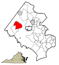
Centreville is a census-designated place (CDP) in Fairfax County, Virginia, United States and a suburb of Washington, D.C. The population was 73,518 as of the 2020 census. Centreville is approximately 20 miles (32 km) west of Washington, D.C.

<span class="mw-page-title-main">Great Falls, Virginia</span> Census-designated place in Virginia, United States

Great Falls is a census-designated place in Fairfax County, Virginia, United States. The population at the 2020 census was 15,953.

<span class="mw-page-title-main">McLean, Virginia</span> Census-designated place and unincorporated community in Virginia, United States

McLean is an unincorporated community and census-designated place in Fairfax County, Virginia, United States. The population of the community was 50,773 at the 2020 census. It is located between the Potomac River and Vienna within the Washington metropolitan area.

<span class="mw-page-title-main">Newington, Virginia</span> Census-designated place in Virginia, United States

Newington is a census-designated place (CDP) in Fairfax County, Virginia, United States. As of the 2020 census, the population was 13,223. The population was 12,943 at the 2010 census. The 2010 census showed a significant decrease after half the population was split off to the newly created Newington Forest CDP.

<span class="mw-page-title-main">Oakton, Virginia</span> Census-designated place in Virginia

Oakton is a census-designated place (CDP) in Fairfax County, Virginia, United States. The population was 36,732 at the 2020 census. Located in Northern Virginia, its center is 16 miles (26 km) west of Washington, D.C.

<span class="mw-page-title-main">Springfield, Virginia</span> Census-designated place in Virginia, United States

Springfield is a census-designated place (CDP) in Fairfax County, Virginia, United States. The Springfield CDP is recognized by the U.S. Census Bureau with a population of 31,339 as of the 2020 census. Previously, per the 2010 census, the population was 30,484. Homes and businesses in bordering CDPs including North Springfield, West Springfield, and Newington are usually given a Springfield mailing address. The population of the collective areas with Springfield addresses is estimated to exceed 100,000. The CDP is a part of Northern Virginia, the most populous region of the Washington Metropolitan Area.

<span class="mw-page-title-main">Tysons, Virginia</span> Census-designated place in Virginia, United States

Tysons, also known as Tysons Corner, is a census-designated place (CDP) in Fairfax County, Virginia, United States, spanning from the corner of SR 123 and SR 7. It is part of the Washington metropolitan area and located in Northern Virginia between McLean and Vienna along the I-495.

<span class="mw-page-title-main">Woodbridge, Virginia</span> Census-designated place in Virginia, United States

Woodbridge is a census-designated place (CDP) in Prince William County, Virginia, United States, located 20 miles (32 km) south of Washington, D.C. Bounded by the Occoquan and Potomac rivers, Woodbridge had 44,668 residents at the 2020 census.

<span class="mw-page-title-main">Ashburn, Virginia</span> Census-designated place in Virginia, United States

Ashburn is a rapidly growing census-designated place (CDP) in Loudoun County, Virginia, United States. At the 2010 United States census, its population was 43,511, up from 3,393 in 1990. It is 30 miles (48 km) northwest of Washington, D.C., and part of the Washington metropolitan area.

<span class="mw-page-title-main">Fairfax Station, Virginia</span> Census-designated place in Virginia, United States

Fairfax Station is a census-designated place (CDP) in Fairfax County, Virginia, United States. The population was 12,420 at the 2020 census. Located in Northern Virginia, its center is located 22 miles (35 km) southwest of Washington, D.C.

<span class="mw-page-title-main">South Riding, Virginia</span> Census-designated place in Virginia

South Riding is a census-designated place and planned community in Loudoun County, Virginia, United States. The South Riding homeowner association was founded in January 1995 to provide services to the community. Neighboring U.S. Route 50 and State Route 28 provide access to the Dulles/Reston/Tysons Corner technology corridor and other major employment centers in Northern Virginia and Washington, D.C.

<span class="mw-page-title-main">Fair Lakes, Virginia</span> Census-designated place in Virginia, United States

Fair Lakes is a census-designated place (CDP) and business park located west of Fairfax in Fairfax County, Virginia, United States. Fair Lakes had a population of 8,404 in 2020.

<span class="mw-page-title-main">Floris, Virginia</span> Census-designated place in Virginia, United States

Floris is a census-designated place (CDP) located within the Oak Hill area of Fairfax County, Virginia, United States. The population at the 2020 census was 8,341.

Sugarland Run is a planned community and census-designated place in Loudoun County, Virginia, United States. The population at the 2010 census was 11,799. In 2020, it was estimated to be 12,956. Sugarland Run is part of the Washington metropolitan area and is 26 miles (42 km) by road northwest of Washington, D.C.

<span class="mw-page-title-main">Fair Oaks, Fairfax County, Virginia</span> Census-designated place in Virginia, United States

Fair Oaks is a census-designated place in Fairfax County, Virginia, United States. The population at the 2020 census was 34,052. It encompasses a large area west of the city of Fairfax, centered on Fair Oaks Mall. Suburban neighborhoods and office parks occupy most of Fair Oaks, largely developed since the 1980s.

<span class="mw-page-title-main">Greenbriar, Virginia</span> Census-designated place in Virginia, United States

Greenbriar is a census-designated place in Fairfax County, Virginia, United States. The population at the 2020 census was 8,421. The community between Fairfax City and Chantilly dates from the late 1960s, when it was developed by Levitt & Sons. The community is famous for having only one road within its territory that does not start with an "M" or "P", which is Acorn Hill. A popular belief is that the roads were named after the architect's two children. One drawback for residents of the community is that with nearly identical sounding named roads in such close proximity to each other and house numbers being the same, the US Postal Service along with UPS and FedEx sometimes deliver items to the wrong house.

<span class="mw-page-title-main">McNair, Virginia</span> Census-designated place in Virginia, United States

McNair is a census-designated place located in the Oak Hill section of Fairfax County, Virginia, United States. It is directly to the east of Washington Dulles International Airport. The population as of the 2020 census was 21,598. Much of the population resides in the McNair Farms planned community. The community has a school called McNair Elementary.

<span class="mw-page-title-main">George Mason, Virginia</span> Census-designated place in Virginia, United States

George Mason is a census-designated place (CDP) in Fairfax County, Virginia, United States. The population at the 2020 census was 11,162. It consists of George Mason University and some adjacent neighborhoods to the south and southwest of the city of Fairfax, and is named for American Founding Father George Mason.

References

  1. 1 2 3 4 5 6 "Chantilly CDP, Virginia". United States Census Bureau. Retrieved December 25, 2022.
  2. "U.S. Census website". United States Census Bureau . Retrieved January 31, 2008.
  3. "US Board on Geographic Names". United States Geological Survey. October 25, 2007. Retrieved January 31, 2008.
  4. "Chantilly CDP". US Census Bureau. Archived from the original on February 26, 2015. Retrieved February 27, 2015.
  5. "2010 CENSUS - CENSUS BLOCK MAP (INDEX): Chantilly CDP, VA" (PDF). City Data. Retrieved February 26, 2015.
  6. 1 2 "Fairfax County History Commission Historical Roadside Marker - Chantilly". Fairfax County Government. Archived from the original on February 26, 2015. Retrieved February 26, 2015.
  7. Hagemann, James A. (1988) The Heritage of Virginia: The Story of Place Names in the Old Dominion. The Donning Co., 297 p.
  8. "George Richard Lee Turberville". Fairfax County Cemetery Preservation Association. Archived from the original on February 26, 2015. Retrieved February 26, 2015.
  9. "US Gazetteer files: 2010, 2000, and 1990". United States Census Bureau. February 12, 2011. Retrieved April 23, 2011.
  10. "Geographic Identifiers: 2010 Demographic Profile Data (G001): Chantilly CDP, Virginia". U.S. Census Bureau, American Factfinder. Retrieved September 22, 2016.[ dead link ]
  11. "Sully District". Fairfax County, Virginia. Retrieved June 6, 2012.
  12. "Census of Population and Housing (1790-2000)". U.S. Census Bureau . Retrieved July 17, 2010.
  13. 1 2 3 "Profile of General Population and Housing Characteristics: 2010 Demographic Profile Data (DP-1): Chantilly CDP, Virginia". U.S. Census Bureau, American Factfinder. Archived from the original on February 13, 2020. Retrieved October 3, 2016.
  14. "Selected Economic Characteristics: 2010–2014 American Community Survey 5-Year Estimates (DP03): Chantilly CDP, Virginia". U.S. Census Bureau, American Factfinder. Archived from the original on February 13, 2020. Retrieved October 3, 2016.
  15. "Contact Us." American Registry for Internet Numbers. Retrieved on September 16, 2009.
  16. 1 2 3 4 5 "Chantilly CDP, Virginia Archived June 28, 2009, at the Wayback Machine ." U.S. Census Bureau. Retrieved on September 16, 2009.
  17. "ARIN Upgrades IPv6 Network Services With Dual Stack GigE Internet Access From NTT America". Red Orbit. Tuesday September 2, 2008. Retrieved on September 16, 2009.
  18. "About Us." Compass Airlines. Retrieved on February 28, 2010.
  19. "About Us Archived July 11, 2007, at the Wayback Machine ." Compass Airlines. Retrieved on September 26, 2009.
  20. "Chantilly CDP, Virginia Archived June 28, 2009, at the Wayback Machine ." U.S. Census Bureau. Retrieved on September 26, 2009.
  21. "Naturalist: Coyotes breeding in Fairfax Co. park". WTOP Radio. August 21, 2014. Retrieved February 26, 2015.
  22. "National Reconnaissance Office". The Washington Post. Retrieved February 26, 2015.
  23. "Intelligence Agencies Must Operate More Like An Enterprise - InformationWeek" . Retrieved January 30, 2018.
  24. "The Evolving Role of the NRO". Federation of American Scientists.
  25. "Meetings - Bilderberg Meetings". www.bilderbergmeetings.org. Archived from the original on April 6, 2019. Retrieved January 30, 2018.
  26. Devereaux, Ryan (June 2, 2012). "Tea Party and Occupy activists rub shoulders at Bilderberg protest". The Guardian. Guardian News and Media Ltd. Retrieved February 25, 2015.
  27. "Library Branches." Fairfax County Public Library. Retrieved on October 21, 2009.