Merrifield, Virginia

Last updated

Merrifield, Virginia
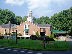
Montessori School-Cedar Lane - panoramio.jpg
A church in Merrifield
Fairfax County Virginia Incorporated and Unincorporated Areas Merrifield highlighted.svg
Location of Merrifield in Fairfax County, Virginia
USA Virginia Northern location map.svg
Red pog.svg
Merrifield, Virginia
USA Virginia location map.svg
Red pog.svg
Merrifield, Virginia
Usa edcp location map.svg
Red pog.svg
Merrifield, Virginia
Coordinates: 38°52′23″N77°14′35″W / 38.87306°N 77.24306°W / 38.87306; -77.24306
CountryUnited States
State Virginia
County Fairfax
Area
  Total2.72 sq mi (7.05 km2)
  Land2.71 sq mi (7.03 km2)
  Water0.008 sq mi (0.02 km2)
Elevation
361 ft (110 m)
Population
 (2020)
  Total20,488
  Density5,602/sq mi (2,163.0/km2)
Time zone UTC−5 (Eastern (EST))
  Summer (DST) UTC−4 (EDT)
Area code 703
FIPS code 51-51192 [1]
GNIS feature ID1493280 [2]

Merrifield is a census-designated place (CDP) in Fairfax County, Virginia, United States. The population was 20,488 at the 2020 census. [3]

Contents

Geography

Apartments along Gallows Road in Merrifield Merrifield, VA, USA - panoramio (2).jpg
Apartments along Gallows Road in Merrifield

Merrifield is located in eastern Fairfax County at 38°52′23″N77°14′35″W / 38.87306°N 77.24306°W / 38.87306; -77.24306 (38.873144, −77.242994). [4] It is bounded by I-66 on the north, the Capital Beltway on the east, Arlington Boulevard (U.S. Route 50) on the south, and Nutley Street (Virginia State Highway 243) on the west. Neighboring communities are Oakton to the west, the town of Vienna to the north, Dunn Loring to the northeast, Idylwood and West Falls Church to the east, Annandale at the southeast corner of Merrifield, Woodburn and Mantua to the south, and the city of Fairfax to the southwest. Downtown Washington, D.C., is 13 miles (21 km) to the east.

According to the United States Census Bureau, the CDP has a total area of 2.7 square miles (7.0 km2), of which 0.01 square miles (0.02 km2), or 0.23%, is water. [5]

Demographics

2020 Census

As of the 2020 census (some information from the 2022 American Community Survey) there were 20,488 people, 9,616 housing units and 9,121 households residing in the CDP. The population density was 7,532.4 inhabitants per square mile (2,906.1/km2). The average housing unit density was 3,535.3 per square mile (1,364.0/km2). The racial makeup of the CDP was 42.85% White, 6.61% African American, 0.47% Native American, 31.26% Asian, 0.07% Pacific Islander, 7.17% from other races, and 11.56% from two or more races. Hispanic or Latino of any race was 15.10% of the population. [3]

Of the households, 44.6% were married couples, 25.3% were a male householder with family but no spouse, and 25.3% were a female householder with family but no spouse. The average family household had 2.87 people. [3]

The median age was 33.8, 17.2% of people were under the age of 18, and 7.5% were 65 years of age or older. Of the residents, 4.1% had Italian ancestry, 49.7% spoke a language other than English at home, and 43.3% were born outside the United States, 45.3% of whom were naturalized citizens. [3]

The median income for a household in the CDP was $134,022, and the median income for a family was $166,076. 4.1% of the population were military veterans, and 79.3% had a batchelor's degree or higher. In the CDP 6.4% of the population was below the poverty line, including 5.5% of those under age 18 and 11.1% of those age 65 or over, with 5.6% of the population without health insurance. [3]

2010 Census

The population was 15,212 at the 2010 census. [5]

2000 Census

As of the census [1] of 2000, there were 11,170 people, 4,396 households, and 2,725 families residing in the CDP. The population density was 4,107.2 inhabitants per square mile (1,585.8/km2). There were 4,534 housing units at an average density of 1,667.1 per square mile (643.7/km2). The racial makeup of the CDP was 54.67% White, 5.94% African American, 0.25% Native American, 29.94% Asian, 0.10% Pacific Islander, 5.00% from other races, and 4.11% from two or more races. Hispanic or Latino of any race were 12.91% of the population.

There were 4,396 households, out of which 28.1% had children under the age of 18 living with them, 48.7% were married couples living together, 8.8% had a female householder with no husband present, and 38.0% were non-families. 25.0% of all households were made up of individuals, and 3.5% had someone living alone who was 65 years of age or older. The average household size was 2.54 and the average family size was 3.06.

In the CDP, the population was spread out, with 19.4% under the age of 18, 10.3% from 18 to 24, 42.7% from 25 to 44, 21.4% from 45 to 64, and 6.2% who were 65 years of age or older. The median age was 33 years. For every 100 females, there were 102.4 males. For every 100 females age 18 and over, there were 103.3 males.

The median income for a household in the CDP was $70,363, and the median income for a family was $74,116. Males had a median income of $55,653 versus $43,095 for females. The per capita income for the CDP was $32,819. About 5.3% of families and 7.4% of the population were below the poverty line, including 11.5% of those under age 18 and 5.8% of those age 65 or over.
Education

Fairfax County Public Schools operates public schools. The FCPS headquarters are located in the Gatehouse Administration Center within the Merrifield CDP. [6] [7]

Economy

The Mosaic District is a mixed-use complex in the format of an ersatz downtown, with buildings lining urban-style streets.

See also

Related Research Articles

<span class="mw-page-title-main">Desert View Highlands, California</span> Census designated place in California, United States

Desert View Highlands is a census-designated place (CDP) in Los Angeles County, California, United States. The population was 2,360 at the 2010 census, up from 2,337 at the 2000 census. It is surrounded by the City of Palmdale.

<span class="mw-page-title-main">Dunn Loring, Virginia</span> Census-designated place in Virginia

Dunn Loring is a census-designated place (CDP) in Fairfax County, Virginia, United States. The population was 9,464 as of the 2020 census. This suburban area is bordered by Merrifield to the south, Vienna to the west, Tysons to the north, and Idylwood to the east. Dunn Loring is located within the Washington metropolitan area.

<span class="mw-page-title-main">Great Falls, Virginia</span> Census-designated place in Virginia, United States

Great Falls is a census-designated place in Fairfax County, Virginia, United States. The population at the 2020 census was 15,953.

<span class="mw-page-title-main">Groveton, Virginia</span> Census-designated place in Virginia, United States

Groveton is a census-designated place (CDP) in Fairfax County, Virginia, United States. The population was 14,598 at the 2010 census, down from 21,296 in 2000 due to a reduction in area. Located south of the city of Alexandria, it encompasses numerous neighborhoods including Groveton, Bucknell Manor, Stoneybrooke, and portions of Hollin Hills. Huntley Meadows Park, Fairfax County's largest park, is located in the southwest part of the CDP.

<span class="mw-page-title-main">Huntington, Virginia</span> Census-designated place in Virginia, United States

Huntington is a census-designated place (CDP) in Fairfax County, Virginia, United States. The population was 11,267 at the 2010 census. It is located next to the southern border of the city of Alexandria and is part of the Washington metropolitan area. Its main component is the namesake Huntington subdivision, a late-1940s neighborhood of mainly duplex homes.

<span class="mw-page-title-main">Idylwood, Virginia</span> Census-designated place in Virginia, United States

Idylwood is a census-designated place (CDP) in Fairfax County, Virginia, United States. The population was 17,954 as of the 2020 census. It originally developed as a suburban community along the route of the Washington and Old Dominion Railroad, and later along Virginia State Route 7. The construction of the Capital Beltway in the 1960s, and I-66 and the Orange Line of the Washington Metrorail system in the 1980s, as well as the concurrent development of nearby Tysons Corner into Washington's leading suburban business district, led to the development of several apartment, townhouse, and small-lot single-family housing complexes, as well as the high-rise Idylwood Towers condominium, in the portion of Idylwood lying to the north of I-66. The area to the south of I-66 remains primarily large-lot single-family.

<span class="mw-page-title-main">Lincolnia, Virginia</span> Census-designated place in Virginia, United States

Lincolnia is a census-designated place (CDP) in Fairfax County, Virginia, United States. The population was 22,828 at the 2010 census, an increase of over 44% from 2000.

<span class="mw-page-title-main">Newington, Virginia</span> Census-designated place in Virginia, United States

Newington is a census-designated place (CDP) in Fairfax County, Virginia, United States. As of the 2020 census, the population was 13,223. The population was 12,943 at the 2010 census. The 2010 census showed a significant decrease after half the population was split off to the newly created Newington Forest CDP.

<span class="mw-page-title-main">North Springfield, Virginia</span> Census-designated place in Virginia, United States

North Springfield is a census-designated place (CDP) in Fairfax County, Virginia, United States. The population was 7,274 at the 2010 census.

<span class="mw-page-title-main">Oakton, Virginia</span> Census-designated place in Virginia

Oakton is a census-designated place (CDP) in Fairfax County, Virginia, United States. The population was 36,732 at the 2020 census. Located in Northern Virginia, its center is 16 miles (26 km) west of Washington, D.C.

<span class="mw-page-title-main">West Springfield, Virginia</span> Census-designated place in Virginia, United States

West Springfield is a census-designated place (CDP) in Fairfax County, Virginia, United States. The population was 23,369 at the 2020 census.

<span class="mw-page-title-main">Mount Gay-Shamrock, West Virginia</span> Census-designated place in West Virginia, United States

Mount Gay-Shamrock is a census-designated place (CDP) in Logan County, West Virginia, United States.

<span class="mw-page-title-main">Piney View, West Virginia</span> Census-designated place in West Virginia, United States

Piney View is a census-designated place (CDP) in Raleigh County, West Virginia, United States. The population was 989 at the 2010 census.

Hollins is a census-designated place (CDP) in Botetourt and Roanoke County, Virginia, United States. Hollins covers much of the area known locally as "North County". The population was 15,574 at the 2020 census. It is part of the Roanoke Metropolitan Statistical Area. The area is also the home of Hollins University in addition to four properties listed on the National Register of Historic Places: the Black Horse Tavern-Bellvue Hotel and Office, Harshbarger House, the Hollins College Quadrangle, and Old Tombstone.

<span class="mw-page-title-main">Fairfax Station, Virginia</span> Census-designated place in Virginia, United States

Fairfax Station is a census-designated place (CDP) in Fairfax County, Virginia, United States. The population was 12,420 at the 2020 census. Located in Northern Virginia, its center is located 22 miles (35 km) southwest of Washington, D.C.

<span class="mw-page-title-main">Dranesville, Virginia</span> Census-designated place in Virginia, United States

Dranesville is a census-designated place (CDP) in Fairfax County, Virginia, United States. Dranesville is located on the Leesburg Pike at its intersection with Georgetown Pike. The U.S. Census Bureau defines Dranesville as a census-designated place (CDP) with a population of 11,921 as of 2010. At the 2020 Census the population was 11,785.

<span class="mw-page-title-main">Fair Lakes, Virginia</span> Census-designated place in Virginia, United States

Fair Lakes is a census-designated place (CDP) and business park located west of Fairfax in Fairfax County, Virginia, United States. Fair Lakes had a population of 8,404 in 2020.

<span class="mw-page-title-main">Fair Oaks, Fairfax County, Virginia</span> Census-designated place in Virginia, United States

Fair Oaks is a census-designated place in Fairfax County, Virginia, United States. The population at the 2020 census was 34,052. It encompasses a large area west of the city of Fairfax, centered on Fair Oaks Mall. Suburban neighborhoods and office parks occupy most of Fair Oaks, largely developed since the 1980s.

<span class="mw-page-title-main">Franklin Farm, Virginia</span> Census-designated place in Virginia, United States

Franklin Farm refers to both a census-designated place (CDP) and a planned community located within the Oak Hill section of Fairfax County, Virginia, United States. It is a suburb of Washington, D.C., located about 20 miles west of the White House. At the 2020 census it had a population of 19,189.

<span class="mw-page-title-main">Laurel Hill, Virginia</span> Census-designated place in Virginia, United States

Laurel Hill is a census-designated place in Fairfax County, Virginia, United States. The population at the 2020 census was 8,307. Formerly part of the Lorton CDP, it comprises most of what was formerly the Lorton Reformatory grounds, which were purchased by Fairfax County in 2002 following the prison's closing and redeveloped as a new suburban community. The name "Laurel Hill" was adopted from Laurel Hill House, an 18th-century structure which had served as the residence of the Superintendent of the Reformatory, and originally was the home of Revolutionary War patriot William Lindsay.

References

  1. 1 2 "U.S. Census website". United States Census Bureau . Retrieved January 31, 2008.
  2. "US Board on Geographic Names". United States Geological Survey. October 25, 2007. Retrieved January 31, 2008.
  3. 1 2 3 4 5 "Explore Census Data". data.census.gov. Retrieved January 23, 2024.
  4. "US Gazetteer files: 2010, 2000, and 1990". United States Census Bureau. February 12, 2011. Retrieved April 23, 2011.
  5. 1 2 "Geographic Identifiers: 2010 Demographic Profile Data (G001): Merrifield CDP, Virginia". U.S. Census Bureau, American Factfinder. Retrieved October 14, 2016.[ dead link ]
  6. "2010 Census Block Maps Merrifield, Virginia." U.S. Census Bureau. Retrieved on November 28, 2012.
  7. Contact Us. Fairfax County Public Schools. Retrieved on November 28, 2012. "Gatehouse Administration Center 8115 Gatehouse Road Falls Church, VA 22042"