Current listings
| [1] | Name on the Register | Image | Date listed [2] | Location | Neighborhood | Description |
|---|---|---|---|---|---|---|
| 1 | Anacostia Historic District |  | October 11, 1978 (#78003050) | Roughly bounded by Martin Luther King, Jr. Avenue; Good Hope Road; 16th Street; Fendall Street; V Street; 15th Street and the Frederick Douglass National Historic Site; Maple View Place 38°51′53″N76°59′08″W / 38.864722°N 76.985556°W | Anacostia | Comprises approximately 20 squares and about 550 buildings built between 1854 and 1930 |
| 2 | Capitol Hill Historic District |  | August 27, 1976 (#76002127) | Roughly bounded by Virginia Ave., SE., S. Capitol St., F St. NE., and 14th Sts. SE & NE.; also roughly bounded by 7th St. NE, I-295, M St. SE and 11th St. SE 38°53′13″N76°59′51″W / 38.886944°N 76.9975°W | Capitol Hill | Second set of boundaries represents a boundary increase of July 3, 2003 |
| 3 | Christ Church |  | May 25, 1969 (#69000291) | 620 G St., SE. 38°52′53″N76°59′52″W / 38.881389°N 76.997778°W | Capitol Hill | |
| 4 | Civil War Fort Sites |  | July 15, 1974 (#74000274) | Arc of sites surrounding central Washington in Maryland, Virginia, and D.C. 38°52′00″N76°57′06″W / 38.866667°N 76.951667°W | All quadrants | At the outset of the Civil War in 1861, Washington became a critical target for rebel attacks but was virtually without protection. The Union Army hastily began construction of a fortified defense line around the city, the physical remnants of which encompass these 19 earthwork forts, including Fort Chaplin, Fort Dupont, Fort Davis, Battery Ricketts, Fort Stanton, and Fort Carroll. [3] See also National Register listings in central D.C., western NW D.C., upper NW D.C., NE D.C., Prince George's County, Maryland, and Fairfax County, Virginia. |
| 5 | Civil War Monuments in Washington, DC |  | September 20, 1978 (#78000257) | Various parks within the original boundaries of city 38°53′23″N76°59′25″W / 38.889722°N 76.990278°W | Various | 18 statues about people and topics related to the Civil War, including 1 in Lincoln Park (NE & SE quadrants), 6 in the upper NW quadrant, and 11 in central Washington. |
| 6 | Commandant's Office, Washington Navy Yard |  | August 14, 1973 (#73002077) | Montgomery Sq. and Dahlgren Ave., SE. 38°52′23″N76°59′43″W / 38.873056°N 76.995278°W | Navy Yard | |
| 7 | Congressional Cemetery |  | June 23, 1969 (#69000292) | 1801 E St., SE. 38°52′52″N76°58′38″W / 38.881111°N 76.977222°W | Barney Circle | Designated a National Historic Landmark June 14, 2011 [4] |
| 8 | Frederick Douglass National Historic Site |  | October 15, 1966 (#66000033) | 1411 W St., SE. 38°51′45″N76°59′04″W / 38.8625°N 76.984444°W | Anacostia | Boundary increase approved December 30, 2022. |
| 9 | Duvall Manor Apartments |  | June 1, 2018 (#100002480) | 3500-3510 Minnesota Ave SE. 38°53′11″N76°57′20″W / 38.8863°N 76.9555°W | Greenway | |
| 10 | Eastern Market |  | May 27, 1971 (#71000998) | 7th and C Sts., SE. 38°53′11″N76°59′48″W / 38.886389°N 76.996667°W | Capitol Hill | Badly damaged by an early-morning fire on April 30, 2007; reopened on June 26, 2009 |
| 11 | East Corner Boundary Marker of the Original District of Columbia |  | November 1, 1996 (#96001249) | 100 feet east of the junction of Eastern and Southern Aves. 38°53′35″N76°54′34″W / 38.893056°N 76.909444°W | NE and SE | See List of Boundary Markers of the Original District of Columbia |
| 12 | Engine Company No. 19 |  | May 10, 2010 (#10000238) | 2813 Pennsylvania Ave., SE 38°52′18″N76°58′01″W / 38.871567°N 76.967052°W | Randle Highlands | |
| 13 | Engine Company No. 25 | 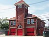 | June 27, 2007 (#07000593) | 3203 Martin Luther King Jr., Ave SE 38°50′35″N77°00′03″W / 38.843056°N 77.000833°W | Congress Heights | |
| 14 | Folger Shakespeare Library |  | June 23, 1969 (#69000294) | 201 E. Capitol St., SE. 38°53′22″N77°00′11″W / 38.889444°N 77.003056°W | Capitol Hill | |
| 15 | Friendship House-The Maples |  | January 18, 1973 (#73002086) | 619 D St., SE., or 630 South Carolina Ave., SE. 38°53′02″N76°59′53″W / 38.883889°N 76.998056°W | Capitol Hill | |
| 16 | The Furies Collective |  | May 2, 2016 (#16000211) | 219 11th St., SE 38°53′13″N76°59′29″W / 38.887024°N 76.991494°W | Capitol Hill | |
| 17 | Gallinger Municipal Hospital Psychopathic Ward | 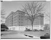 | February 27, 1989 (#89000074) | Reservation 13, 19th St. and Massachusetts Ave., SE 38°53′04″N76°58′37″W / 38.8844°N 76.9769°W | Barney Circle | |
| 18 | Main Gate, Washington Navy Yard |  | August 14, 1973 (#73002098) | 8th and M Sts., SE. 38°52′35″N76°59′43″W / 38.8764°N 76.9953°W | Navy Yard | More commonly known as the Latrobe Gate. |
| 19 | Main Sewerage Pumping Station, District of Columbia |  | May 24, 2012 (#12000297) | 125 O St., SE 38°52′26″N77°00′12″W / 38.8738°N 77.0034°W | Navy Yard | |
| 20 | Old Naval Hospital |  | May 3, 1974 (#74002171) | 921 Pennsylvania Ave., SE. 38°52′58″N76°59′36″W / 38.8828°N 76.9933°W | Capitol Hill | |
| 21 | Quarters A, Washington Navy Yard |  | August 14, 1973 (#73002111) | East of the main gate and south of M St., SE., in the navy yard 38°52′34″N76°59′41″W / 38.8761°N 76.9947°W | Navy Yard | |
| 22 | Quarters B, Washington Navy Yard |  | August 14, 1973 (#73002112) | Charles Morris Ave., SE. 38°52′32″N76°59′39″W / 38.8756°N 76.9942°W | Navy Yard | |
| 23 | St. Elizabeths Hospital |  | April 26, 1979 (#79003101) | 1100 Alabama Ave., SE. [5] 38°51′01″N76°59′40″W / 38.8503°N 76.9944°W | SE | |
| 24 | St. Mark's Church |  | May 8, 1973 (#73002117) | 3rd and A Sts., SE. 38°53′18″N77°00′06″W / 38.8883°N 77.0017°W | Capitol Hill | |
| 25 | Saint Paul African Union Methodist Church |  | July 28, 2011 (#11000481) | 401 I St., SE. 38°52′45″N77°00′02″W / 38.8792°N 77.0006°W | Navy Yard | |
| 26 | Seafarers Boat Club | May 2, 2022 (#100007666) | 1950 M St. SE 38°52′44″N76°58′29″W / 38.8790°N 76.9747°W | |||
| 27 | John Philip Sousa Junior High School |  | August 7, 2001 (#01001045) | 3650 Ely Place, SE. 38°53′01″N76°57′08″W / 38.8835°N 76.9522°W | Fort Dupont | In 1950, eleven African American students were denied admission to the newly constructed all-white Sousa school. This action was eventually overturned in the landmark 1954 Supreme Court decision in Bolling v. Sharpe , which made segregated public schools illegal in the District of Columbia. The defeat of the legal doctrine "separate but equal" was a significant landmark in the modern Civil Rights Movement. |
| 28 | Southeast Branch Library | 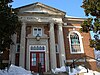 | June 14, 2021 (#100006651) | 403 7th St. SE 38°53′03″N76°59′47″W / 38.8841°N 76.9963°W | ||
| 29 | Southeast No. 1 Boundary Marker of the Original District of Columbia |  | November 1, 1996 (#96001248) | 30 feet south of the junction of Southern Ave. and D St., SE 38°52′58″N76°55′20″W / 38.8828°N 76.9223°W | Marshall Heights | |
| 30 | Southeast No. 2 Boundary Marker of the Original District of Columbia |  | November 1, 1996 (#96001247) | 4345 Southern Ave. 38°52′20″N76°56′09″W / 38.8722°N 76.9358°W | Fort Davis | |
| 31 | Southeast No. 3 Boundary Marker of the Original District of Columbia |  | November 1, 1996 (#96001246) | 3908 Southern Ave. 38°51′43″N76°56′55″W / 38.8619°N 76.9486°W | Fairfax Village | |
| 32 | Southeast No. 5 Boundary Marker of the Original District of Columbia |  | November 1, 1996 (#96001245) | 280 feet northeast of the junction of Southern Ave. and Valley Terrace 38°50′31″N76°58′29″W / 38.8419°N 76.9747°W | Shipley Terrace | |
| 33 | Southeast No. 6 Boundary Marker of the Original District of Columbia |  | November 1, 1996 (#96001244) | 901 Southern Ave. 38°49′54″N76°59′17″W / 38.8317°N 76.9881°W | Washington Highlands | |
| 34 | Southeast No. 7 Boundary Marker of the Original District of Columbia |  | November 1, 1996 (#96001243) | 25 feet northeast of the junction of Southern Ave. and Indian Head Rd. 38°49′17″N77°00′05″W / 38.8214°N 77.0014°W | Bellevue | |
| 35 | U.S. Marine Corps Barracks and Commandant's House | 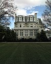 | December 27, 1972 (#72001435) | 8th and I Sts., SE 38°52′48″N76°59′41″W / 38.88°N 76.9947°W | Capitol Hill | |
| 36 | Suitland Parkway | 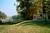 | June 2, 1995 (#95000604) | From the Anacostia River in the District of Columbia to Pennsylvania Ave. in Prince George's County, Maryland 38°51′12″N76°59′00″W / 38.8533°N 76.9833°W | Various | |
| 37 | Texas Gardens Apartments |  | June 1, 2018 (#100002481) | 1741 28th St SE 38°52′04″N76°58′04″W / 38.8679°N 76.9678°W | Randle Highlands | |
| 38 | Washington and Georgetown Railroad Car House | 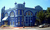 | November 14, 2006 (#06000516) | 770 M St. SE 38°52′44″N76°59′45″W / 38.8789°N 76.9958°W | Navy Yard | Commonly known as the Blue Castle |
| 39 | Washington Navy Yard |  | June 19, 1973 (#73002124) | 8th and M Sts., SE, also 200 Tingey St. SE 38°52′25″N76°59′47″W / 38.8736°N 76.9964°W | Navy Yard | Boundary increase approved June 29, 2023. |
| 40 | Washington Yacht Club |  | October 2, 2020 (#100005305) | 1500 M St. SE. 38°52′33″N76°59′09″W / 38.8759°N 76.9858°W | ||
| 41 | Watterston House | 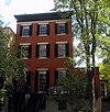 | January 17, 1992 (#91001942) | 224 2nd St., SE. 38°53′11″N77°00′13″W / 38.8864°N 77.0036°W | Capitol Hill | |
| 42 | Woodlawn Cemetery |  | December 20, 1996 (#96001499) | 4611 Benning Rd., SE 38°53′06″N76°56′19″W / 38.885°N 76.9386°W | Benning Ridge |