Capitol Hill

Last updated

Capitol Hill
Aerial view, United States Capitol building 04492v (cropped).jpg
8th Street SE sidewalk scene.jpg
Capitol Hill row houses.jpg
Flickr - USCapitol - Russell Senate Office Building in Spring (cropped).jpg
Post Wikimania 2012, Washington (20120715-DSC03671) (cropped).jpg
DC Capitol Historic District (cropped).jpg
Top: U.S. Capitol Complex; middle top: Barracks Row (left) and historic rowhomes (right); middle bottom: Russell Senate Building (left) and Eastern Market (right) bottom: view over Capitol Hill.
DC Neighborhoods - Capitol Hill.svg
Country United States
District Washington, D.C.
Quadrant Northeast and Southeast
Ward6

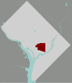
Capitol Hill is a neighborhood in Washington, D.C., located in both Northeast D.C. and Southeast D.C.. Dominated by the United States Capitol, which sits on the highest point of Capitol Hill, it is one of the oldest historic districts in Washington. Home to around 35,000 people in just under 2 square miles (5 km2), Capitol Hill is also one of the most densely populated neighborhoods. [1] The name "Capitol Hill" is frequently used as a metonym for the U.S. Congress.

Contents

Capitol Hill is famed as a center of the United States Government, home numerous important institutions including the U.S. Congress, the Supreme Court, the Library of Congress, and more. Apart from government, the neighborhood is largely residential, but maintains notable commercial hubs along Pennsylvania Avenue, such as Eastern Market and Barracks Row.

History

18th century

A view of Capitol Hill and Navy Yard below, in 1833. Capitol Hill - George Cooke, 1833 (cropped).jpg
A view of Capitol Hill and Navy Yard below, in 1833.

L'Enfant selected the location of the Capitol (the "Congress House") in his 1791 design for the federal capital city (see: L'Enfant Plan). He referred to the hill chosen as the site of the future Congress House as "Jenkins Hill" or "Jenkins Heights". [2] [3]

However, the tract of land had for many years belonged to the Carroll family and was noted in their records of ownership as "Rome". [4] While a man named Thomas Jenkins had once pastured some livestock at the site of the Capitol (and thus his name was associated with the site), artist John Trumbull, who would paint several murals inside the Capitol's rotunda, reported in 1791 that the site was covered with a thick wood, making it an unlikely place for livestock to graze. Research published in 2004 by the Capitol Hill Historical Society showed that Jenkins' land was seven blocks east of the site of the Capitol and that L'Enfant was likely to have given Jenkins' name to the general location. [2]

While serving in 1793 as President George Washington's Secretary of State, Thomas Jefferson named Capitol Hill, invoking the famous Temple of Jupiter Optimus Maximus on the Capitoline Hill, one of the seven hills of Rome. [5] However, the connection between the two is not completely clear. [6]

The Marine Barracks, established in 1801, are the oldest U.S. Marines facility and their main ceremonial ground. It is also the residence of the Commandant of the Marine Corps. U.S. Marines pass in review at the closing the retirement ceremony for Gen. George J. Flynn, not shown at Marine Barracks Washington in Washington, D.C., May 9, 2013 130509-M-LU710-372 (cropped).jpg
The Marine Barracks, established in 1801, are the oldest U.S. Marines facility and their main ceremonial ground. It is also the residence of the Commandant of the Marine Corps.

The neighborhood that is now called Capitol Hill started to develop when the government began work at two locations, the Capitol and the Washington Navy Yard. It became a distinct community between 1799 and 1810 as the federal government became a major employer. The first stage in its early history was that of a boarding house community developed for members of Congress. In the early years of the Republic, few Congressmen wished to establish permanent residence in the city. Instead, most preferred to live in boarding houses within walking distance of the Capitol. [1]

In 1799, the Washington Navy Yard was established on the banks of the Anacostia River, providing jobs to craftsmen who built and repaired ships. Many of the craftsmen who were employed both at the Navy Yard and in the construction of the Capitol chose to live within walking distance, to the east of the Capitol and the north of the Navy Yard. They became the original residential population of the neighborhood.

19th century

Old Naval Hospital, built in 1866. Old-naval-hospital.JPG
Old Naval Hospital, built in 1866.

In 1801, Thomas Jefferson, who was at the time President of the United States, selected the location of the Marine Barracks, which had to be within marching distance of both the Capitol and the White House, near the Washington Navy Yard. By 1810, shops, goldsmiths, blacksmiths, and churches were flourishing in the area.

The Civil War resulted in more construction in the Capitol Hill area, including the building of hospitals. Construction of new houses continued in the 1870s and 1880s. The neighborhood began to divide along racial and economic class lines. Electricity, piped water, and plumbing were introduced in the 1890s, and were first available in the downtown areas of the District of Columbia, including Capitol Hill. There was a real estate development boom between 1890 and 1910 as the Capitol Hill area became one of the first neighborhoods having these modern conveniences.

20th century

The Supreme Court, built in 1935. Oblique facade 3, US Supreme Court.jpg
The Supreme Court, built in 1935.

In 1976, the Capitol Hill Historic District was placed on the National Register of Historic Places. It is one of the largest historic districts in the United States. [1] The boundaries of the historic district are irregular, extending southward from F Street NE, as far east as 14th Street, as far west as South Capitol Street, and with a southern limit marked chiefly by Virginia Avenue but including some territory as far south as M Street SE. It includes buildings from the Federal period (1800 to 1820) through 1919, but most of the buildings are late Victorian.

Capitol Hill has remained a fairly stable middle-class neighborhood throughout its existence. It suffered a period of economic decline and rising crime in the mid-20th century but gradually recovered. During the so-called "crack epidemic" of the 1980s, its fringes were often affected. Beginning in the 1990s, the neighborhood has undergone intense gentrification. [7]

Landmarks

Capitol Hill Historic District
East Capitol Street Car Barn (cropped).jpg
Coordinates 38°53′23″N77°00′40″W / 38.88972°N 77.01111°W / 38.88972; -77.01111
Website Map
NRHP reference No. 76002127  (original)
03000585  (increase)
Significant dates
Added to NRHPAugust 27, 1976
Boundary increaseJuly 3, 2003

Capitol Hill's landmarks include not only the United States Capitol, but also the Senate and House office buildings, the Supreme Court building, the Library of Congress, the Marine Barracks, the Washington Navy Yard, and Congressional Cemetery, which are collectively part of the Capitol Complex.

Also, the Folger Shakespeare Library is located in Capitol Hill. It is a research library and museum that houses the world's largest collection of material related to English writer William Shakespeare [8] and third-largest collection of English books printed before 1641. [9] [10] The Folger Library houses a large museum and also operates the Folger Theatre, which is known for being a leading interpreter of Shakespeare's works. [11]

Capitol Hill is, however, largely a residential neighborhood composed predominantly of rowhouses of different stylistic varieties and periods. Side by side exist early 19th century manor houses, Federal townhouses, small frame dwellings, ornate Italianate bracketed houses, and the late 19th century press brick rowhouses with their often whimsical decorative elements combining Richardsonian Romanesque, Queen Anne, and Eastlakian motifs. [1]

Eastern Market, a public market and food hall, was built in 1873. Eastern Market - facade.JPG
Eastern Market, a public market and food hall, was built in 1873.

In the 1990s, gentrification and the booming economy of the District of Columbia meant that the neighborhood's non-historic and obsolete buildings began to be replaced. New buildings, which have to comply with height limits and other restrictions, are often done in a decorative modernist style, many by Amy Weinstein, whose designs feature polychrome brickwork set in patterned relief. [12] [13]

The Folger Shakespeare Library, the world's largest collection of works by William Shakespeare and a primary repository for rare materials from the early modern period of Europe. Folger Reading Room (cropped).jpg
The Folger Shakespeare Library, the world's largest collection of works by William Shakespeare and a primary repository for rare materials from the early modern period of Europe.

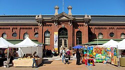
The main retail corridor of Capitol Hill is Pennsylvania Avenue, a lively commercial street with shops, restaurants and bars. Eastern Market is an 1873 public market on 7th Street SE, where vendors sell fresh meat and produce in indoor stalls and at outdoor farmers' stands. It is also the site of an outdoor flea market every weekend. After a major fire gutted the main market building on April 30, 2007, it underwent restoration and reopened on June 26, 2009. One of the most beloved stores, Fragers Hardware, has been based on Pennsylvania Avenue for nearly 100 years before it suffered a fire similar in destructiveness to the Eastern Market fire. It has successfully rebuilt on the same location. [14]

Barracks Row at 8th Street SE, named because of its proximity to the U.S. Marine Barracks, is one of the city's oldest commercial corridors. [15] It dates to the late 18th century and has recently been revitalized. Barracks Row is located immediately south of Eastern Market, which is a public market dating back to 1871. The Eastern Market and Barracks Row area have many restaurants and shops. This area is the oldest commercial district in the city, in part due to its proximity to the Washington Navy Yard.

A new addition to Capitol Hill is a community center named Hill Center. Hill Center is housed in the restored Old Naval Hospital at the corner of 9th and Pennsylvania Avenue SE. The rehabilitation of the Old Naval Hospital combines the restoration of a historically significant landmark with the cutting-edge technologies of modern "green" architecture. Hill Center is a vibrant new home for cultural, educational, and civic life on Capitol Hill.

Parks

The Emancipation Memorial at Lincoln Park, erected in 1876. Emancipation Memorial (df384e72-7cb4-4d39-be4e-1a0898f48157).jpg
The Emancipation Memorial at Lincoln Park, erected in 1876.

The Capitol Hill neighborhood is home to many parks and squares. Lincoln Park is located immediately east of the U.S. Capitol on East Capitol Street. It is home to Thomas Ball's controversial Emancipation Memorial as well as Robert Berks' statue of Mary McLeod Bethune. At the intersection between Maryland Avenue and Massachusetts Avenue on the northern part of the neighborhood is Stanton Park. The park is named after Edwin Stanton, who was U.S. Secretary of War during the American Civil War.

Located immediately south of the U.S. Capitol is Spirit of Justice Park, which is separated into two identically sized sections by South Capitol Street. Southeast of this park is Folger Park, which was named after former Secretary of the Treasury Charles J. Folger. At the intersection of Pennsylvania Avenue and North Carolina Avenue is Seward Square. Since those two roads intersect diagonally in the middle of the square, Sward Square is divided into four triangular sections. A couple blocks immediately south of this square is the location of Marion Park. This park goes by the name Turtle Park because of a large cement turtle in its playground. On the southern edge of the neighborhood is Garfield Park, named after President Garfield.

Education

Eastern High School, built in 1923. Kimo photo.jpg
Eastern High School, built in 1923.

There are multiple schools within the boundaries, including District of Columbia Public Schools elementary schools (Tyler Elementary School, Brent Elementary School, Watkins Elementary School, Maury Elementary School, Peabody Elementary School, and Payne Elementary School).

St. Peter's School on Capitol Hill, the only Catholic school, Capitol Hill Day School, Stuart-Hobson Middle School, Elliot-Hine Jr. High School, and many others.

Eastern High School was originally founded in 1890 as Capitol Hill High School. Its current collegiate gothic campus was built in 1923.

Notable residents

The Equestrian statue of Nathanael Greene at Stanton Park. Stanton Park Rx DC 17597 (8188201200) (cropped).jpg
The Equestrian statue of Nathanael Greene at Stanton Park.
The Mary McLeod Bethune Memorial at Lincoln Park. Mary McLeod Bethune Memorial, Washington, D.C LCCN2011630730.tif
The Mary McLeod Bethune Memorial at Lincoln Park.

Related Research Articles

<span class="mw-page-title-main">Pennsylvania Avenue</span> Street in Maryland and Washington, D.C., US

Pennsylvania Avenue is a primarily diagonal street in Washington, D.C. that connects the United States Capitol with the White House and then crosses northwest Washington, D.C. to Georgetown. Traveling through southeast Washington from the Capitol, it enters Prince George's County, Maryland, and becomes MD Route 4 and then MD Route 717 in Upper Marlboro, and finally Stephanie Roper Highway.

<span class="mw-page-title-main">Southeast (Washington, D.C.)</span> Quadrant in the United States

Southeast is the southeastern quadrant of Washington, D.C., the capital of the United States, and is located south of East Capitol Street and east of South Capitol Street. It includes the Capitol Hill and Anacostia neighborhoods, the Navy Yard, the Joint Base Anacostia-Bolling (JBAB), the U.S. Marine Barracks, the Anacostia River waterfront, Eastern Market, the remains of several Civil War-era forts, historic St. Elizabeths Hospital, RFK Stadium, Nationals Park, and the Congressional Cemetery. It also contains a landmark known as "The Big Chair," located on Martin Luther King Jr. Avenue. The quadrant is split by the Anacostia River, with the portion that is west of the river sometimes referred to as "Near Southeast". Geographically, it is the second-smallest quadrant of the city.

<span class="mw-page-title-main">Eastern Market, Washington, D.C.</span> United States historic place

The Eastern Market is a public market in the Capitol Hill neighborhood of Washington, D.C., housed in a 19th-century brick building. Eastern Market was listed on the National Register of Historic Places in 1971. It is located on 7th Street, S.E., a few blocks east of the U.S. Capitol between North Carolina Avenue SE and C Street SE. Badly damaged by an early-morning fire in 2007, the market building reopened in the summer of 2009 following an extensive renovation.

<span class="mw-page-title-main">Judiciary Square</span> Neighborhood in Ward 6, United States

Judiciary Square is a neighborhood in the northwest quadrant of Washington, D.C., the vast majority of which is occupied by various federal and municipal courthouses and office buildings. Judiciary Square is located roughly between Pennsylvania Avenue to the south, H Street to the north, 6th Street to the west, and 3rd Street to the east. The center of the neighborhood is an actual plaza named Judiciary Square. The Square itself is bounded by 4th Street to the east, 5th Street to the west, D Street and Indiana Avenue to the south, and F Street to the north. The neighborhood is served by the Judiciary Square station on the Red Line of the Washington Metro, in addition to Washington Metropolitan Area Transit Authority bus stops.

<span class="mw-page-title-main">History of Washington, D.C.</span>

The history of Washington, D.C., is tied to its role as the capital of the United States. The site of the District of Columbia along the Potomac River was first selected by President George Washington. The city came under attack during the War of 1812 in an episode known as the Burning of Washington. Upon the government's return to the capital, it had to manage the reconstruction of numerous public buildings, including the White House and the United States Capitol. The McMillan Plan of 1901 helped restore and beautify the downtown core area, including establishing the National Mall, along with numerous monuments and museums.

<span class="mw-page-title-main">Bloomingdale (Washington, D.C.)</span> Place in the United States

Bloomingdale is a neighborhood in the Northwest quadrant of Washington, D.C., less than two miles (3 km) north of the United States Capitol building. It is a primarily residential neighborhood, with a small commercial center near the intersection of Rhode Island Avenue and First Street NW featuring bars, restaurants, and food markets.

<span class="mw-page-title-main">Massachusetts Avenue (Washington, D.C.)</span> Major road in Washington, D.C., U.S.

Massachusetts Avenue is a major diagonal transverse road in Washington, D.C., and the Massachusetts Avenue Historic District is a historic district that includes part of it.

<span class="mw-page-title-main">South Capitol Street</span>

South Capitol Street is a major street dividing the southeast and southwest quadrants of Washington, D.C., in the United States. It runs south from the United States Capitol to the D.C.–Maryland line, intersecting with Southern Avenue. After it enters Maryland, the street becomes Indian Head Highway at the Eastover Shopping Center, a terminal or transfer point of many bus routes.

<span class="mw-page-title-main">DC Circulator</span> Bus system in Washington, D.C

The DC Circulator is a bus system in Washington, D.C. The District of Columbia Department of Transportation operates the service in a public–private partnership with RATP Dev.

<span class="mw-page-title-main">Truxton Circle</span> Place in the United States

Truxton Circle, sometimes known as East Shaw, is a neighborhood of Washington, D.C., located in Northwest D.C.

<span class="mw-page-title-main">Lincoln Park (Washington, D.C.)</span> Park in Washington, D.C., U.S.

Lincoln Park is the largest urban park located in the Capitol Hill neighborhood of Washington, D.C. It was known historically as Lincoln Square. From 1862 to 1865, it was the site of the largest hospital in Washington, DC: Lincoln Hospital.

<span class="mw-page-title-main">Barney Circle</span> Neighborhood in the United States

Barney Circle is a small residential neighborhood located between the west bank of the Anacostia River and the eastern edge of Capitol Hill in southeast Washington, D.C., in the United States. The neighborhood is characterized by its sense of community, activism, walkability, and historic feel. The neighborhood's name derives from the eponymous former traffic circle Pennsylvania Avenue SE just before it crosses the John Philip Sousa Bridge over the Anacostia. The traffic circle is named for Commodore Joshua Barney, Commander of the Chesapeake Bay Flotilla in the War of 1812.

<span class="mw-page-title-main">Washington City Canal</span>

The Washington City Canal was a canal in Washington, D.C., that operated from 1815 until the mid-1850s. The canal connected the Anacostia River, termed the "Eastern Branch" at that time, to Tiber Creek, the Potomac River, and later the Chesapeake and Ohio (C&O) Canal. The canal fell into disuse during the late 19th century and the city government covered over or filled in various sections in 1871.

<span class="mw-page-title-main">Navy Yard (Washington, D.C.)</span> Place in the United States

Navy Yard is a neighborhood of Washington, D.C., located in Southeast D.C. Navy Yard, situated along the Anacostia Riverfront south of Capitol Hill, takes its name from Washington Navy Yard, the administrative seat of the U.S. Navy. Historically an industrial area, today Navy Yard is a popular entertainment district, home to Nationals Park, a notable nightlife scene, and numerous waterfront esplanades.

Washington, D.C., is the capital city and federal district of the United States. Below is a list of Washington, D.C.-related articles.

<span class="mw-page-title-main">Quadrants of Washington, D.C.</span> Geographical quadrant

Washington, D.C., is administratively divided into four geographical quadrants of unequal size, each delineated by their ordinal directions from the medallion located in the Crypt under the Rotunda of the Capitol. Street and number addressing, centered on the Capitol, radiates out into each of the quadrants, producing a number of intersections of identically named cross-streets in each quadrant. Originally, the District of Columbia was a near-perfect square but contained more than one settlement; the Capitol was to be the center of the City of Washington. Thus, the Capitol was never located at the geographic center of the whole territory, which was eventually north of the Potomac River, consolidated into one city. As a result, the quadrants are of greatly varying size. Northwest is quite large, encompassing over a third of the city's geographical area, while Southwest is little more than a few neighborhoods, large parks, and a military base.

<span class="mw-page-title-main">Outline of Washington, D.C.</span> Overview of and topical guide to District of Columbia

The following outline is provided as an overview of and topical guide to District of Columbia:

<span class="mw-page-title-main">L'Enfant Plan</span> United States historic place; street and land use plan for Washington, DC

The L'Enfant Plan for the city of Washington is the urban plan developed in 1791 by Major Pierre (Peter) Charles L'Enfant for George Washington, the first president of the United States.

<span class="mw-page-title-main">Folger Park</span> Park in Washington, D.C., U.S.

Folger Park is a public park named after former Secretary of the Treasury Charles J. Folger. It is located at 2nd Street and D Street, Southeast, Washington, D.C., in the Capitol Hill neighborhood.

<span class="mw-page-title-main">Barracks Row</span> Commercial district in Washington, D.C., USA

Barracks Row is a commercial strip along 8th Street SE that connects the Navy Yard and Capitol Hill neighborhoods in the Southeast Quadrant of Washington, D.C., south of Eastern Market, between M Street SE and Pennsylvania Avenue SE. The area takes its name from the Marine Barracks, also known as 8th & I, which it faces along 8th Street SE.

References

  1. 1 2 3 4 "Capitol Hill Historic District". National Register of Historic Places Travel Itinerary. National Park Service . Retrieved February 18, 2013.
  2. 1 2 Vlach, John Michael (Spring 2004). "The Mysterious Mr. Jenkins of Jenkins Hill". United States Capitol Historical Society. Archived from the original on October 23, 2008. Retrieved August 20, 2008.
  3. (1) "History of Capitol Hill". Architecture. Washington, D.C.: Architect of the Capitol. Archived from the original on April 27, 2017. Retrieved April 30, 2017.
    (2) L'Enfant, P.C. (June 22, 1791). "To The President of the United States". L'Enfant's Reports to President Washington Bearing Dates of March 26, June 22, and August 19, 1791: Records of the Columbia Historical Society. Washington, D.C.: Columbia Historical Society (1899). 2: 34–35. Retrieved December 28, 2011 via Google Books.
  4. Meehan, Thomas Francis (1908). "Daniel Carroll"  . Catholic Encyclopedia . Vol. 3.
  5. (1) Bordewich, Fergus M. (September 2008). "A Capitol Vision From a Self-Taught Architect". Smithsonian Magazine. Smithsonian.com. Retrieved April 30, 2017.
    (2) Harper, Douglas. "Capitol". Online Etymology Dictionary .
  6. Hodgkins, George W. (1960). "Naming the Capitol and the Capital". Records of the Columbia Historical Society, Washington, D.C. 60/62: 36–53. JSTOR   40067217.
  7. "Shoppers Celebrate Reopening of Eastern Market on Capitol Hill". The Washington Post. July 2, 2009. Retrieved March 6, 2012.
  8. "About the Folger". January 21, 2015. Retrieved February 12, 2022.
  9. Infinite Variety, p. 95.
  10. See also "The Collection" Archived 2007-12-25 at the Wayback Machine on the Folger site.
  11. "Helen Hayes Awards" Archived 2015-07-03 at the Wayback Machine list on Folgerpedia
  12. Mencimer, Stephanie (October 25, 1996). "Building Blocks Architect Amy Weinstein Is Redesigning Capitol Hill One Block at a Time". Washington City Paper. Retrieved September 13, 2017.
  13. Hurley, Amanda kolson (September 12, 2014). "Amy Weinstein's New Eastern Market Building Is Exuberantly Victorian". Washington City Paper. Retrieved September 13, 2017.
  14. "Frager's Hardware gets new life in changing Capitol Hill". WUSA.
  15. "Tour of Duty: Barracks Row Heritage Trail". Cultural Tourism DC. City of Washington. Retrieved February 18, 2013.
  16. 1 2 Shultz, Scott G. (1998). Sewall–Belmont House (Alva Belmont House) (National Woman's Party Headquarters). Sewall-Belmont House National Historic Site (PDF) (Report). Washington, D.C.: Historic American Buildings Survey, National Park Service.
  17. 1 2 Fogle, Jeanne (2009). A Neighborhood Guide to Washington, D.C.'s Hidden History. Charleston, S.C.: History Press. ISBN   9781596296527.
  18. Hermann, Peter (September 1, 2017). "Isaac Fulwood, Washington police chief during tumultuous era, dies at 77". The Washington Post . Retrieved September 30, 2017.
  19. "Ana Gasteyer Returns to Her Hometown of Washington for Some Politicking". Washingtonian . March 20, 2012. Retrieved January 13, 2022.
  20. DeBonis, Mike (March 12, 2012). "Ana Gasteyer is latest celeb to back D.C. Council campaign". The Washington Post. Retrieved January 13, 2022.
  21. "Ana Gasteyer Plays a Car Company CEO Who Doesn't Know How to Drive in American Auto". Late Night with Seth Meyers . YouTube . Retrieved January 13, 2022.
  22. Janezich, Larry (September 12, 2016). "City Council Chair Mendelson Purchases Hill East Home Across From Watkins School". Capitol Hill Corner. Retrieved February 17, 2017.
  23. Nguyen, Tina (August 9, 2016). "Bernie Sanders Buys His Third House". Vanity Fair . Retrieved February 17, 2021.
  24. Fettig, Jason K. "'The President's Own' United States Marine Band". marines.mil. Retrieved August 14, 2020.