Washington, D.C., formally the District of Columbia and commonly known as Washington or D.C., is the capital city and federal district of the United States. The city is on the Potomac River, across from Virginia, and shares land borders with Maryland to its north and east. It was named for George Washington, the first president of the United States. The district is named for Columbia, the female personification of the nation.

The National Mall is a landscaped park near the downtown area of Washington, D.C., the capital city of the United States. It contains and borders a number of museums of the Smithsonian Institution, art galleries, cultural institutions, and various memorials, sculptures, and statues. It is administered by the National Park Service (NPS) of the United States Department of the Interior as part of the National Mall and Memorial Parks unit of the National Park System. The park receives approximately 24 million visitors each year. Designed by Pierre L'Enfant, the "Grand Avenue" or Mall was to be a democratic and egalitarian space—the complete opposite of the gardens of Versailles where only royalty and nobility accessed similar spaces in size and scope.

Southwest is the southwestern quadrant of Washington, D.C., the capital of the United States, and is located south of the National Mall and west of South Capitol Street. It is the smallest quadrant of the city, and contains a small number of named neighborhoods and districts, including Bellevue, Southwest Federal Center, the Southwest Waterfront, Buzzard Point, and the military installation known as Joint Base Anacostia–Bolling.
Northwest is the northwestern quadrant of Washington, D.C., the capital of the United States, and is located north of the National Mall and west of North Capitol Street. It is the largest of the four quadrants of the city, and it includes the central business district, the Federal Triangle, and the museums along the northern side of the National Mall, as well as many of the District's historic neighborhoods.

L'Enfant Plaza is a complex of four commercial buildings grouped around a large plaza in the Southwest section of Washington, D.C., United States. Immediately below the plaza and the buildings is La Promenade shopping mall.

Constitution Avenue is a major east–west street in the northwest and northeast quadrants of the city of Washington, D.C., in the United States. It was originally known as B Street, and its western section was greatly lengthened and widened between 1925 and 1933. It received its current name on February 26, 1931, though it was almost named Jefferson Avenue in honor of Thomas Jefferson.
The National Capital Parks was a unit of the National Park System of the United States, now divided into multiple administrative units. It encompasses a variety of federally owned properties in and around the District of Columbia including memorials, monuments, parks, interiors of traffic circles and squares, triangles formed by irregular intersections, and other open spaces.
National Mall and Memorial Parks is an administrative unit of the National Park Service (NPS) encompassing many national memorials and other areas in Washington, D.C. Federally owned and administered parks in the capital area date back to 1790, some of the oldest in the United States. In 1933, they were transferred to the control of the National Park Service. These parks were known as the National Capital Parks from their inception until 1965. The NPS now operates multiple park groupings in the D.C. area, including National Capital Parks-East, Rock Creek Park, President's Park, and George Washington Memorial Parkway. National Mall and Memorial Parks also provides technical assistance for the United States Navy Memorial.
This is a list of properties and districts in Washington, D.C., on the National Register of Historic Places. There are more than 600 listings, including 74 National Historic Landmarks of the United States and another 13 places otherwise designated as historic sites of national importance by Congress or the President.

The DC Circulator is a bus system in Washington, D.C. The District of Columbia Department of Transportation operates the service in a public–private partnership with RATP Dev.
The streets and highways of Washington, D.C., form the core of the surface transportation infrastructure in Washington, D.C., the federal capital of the United States. Given that it is a planned city, the city's streets follow a distinctive layout and addressing scheme. There are 1,500 miles (2,400 km) of public roads in the city, of which 1,392 miles (2,240 km) are owned and maintained by city government.
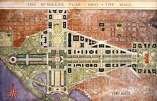
The McMillan Plan is a comprehensive planning document for the development of the monumental core and the park system of Washington, D.C., the capital of the United States. It was written in 1902 by the Senate Park Commission. The commission is popularly known as the McMillan Commission after its chairman, Senator James McMillan of Michigan.

Downtown is the central business district of Washington, D.C., located in Northwest D.C. It is the third largest central business district in the United States. The "Traditional Downtown" has been defined as an area roughly between Union Station in the east and 16th Street NW in the west, and between the National Mall on the south and Massachusetts Avenue on the north, including Penn Quarter. However, nowadays, Downtown D.C. can often refer to a larger area, as the DC Office of Planning states:
…most residents, workers, and visitors think of Downtown in a broader sense — including areas as far north as Dupont Circle, as far west as Foggy Bottom, and as far east as Capitol Hill. Only about half of the central city workforce is located within the city’s traditional Downtown.

The Capitol Reflecting Pool is a reflecting pool in Washington, D.C., United States. It lies to the west of the United States Capitol and is the westernmost element of the Capitol grounds. The Capitol Dome and the Ulysses S. Grant Memorial are reflected in its waters.
Washington, D.C., is administratively divided into four geographical quadrants of unequal size, each delineated by their ordinal directions from the medallion located in the Crypt under the Rotunda of the Capitol. Street and number addressing, centered on the Capitol, radiates out into each of the quadrants, producing a number of intersections of identically named cross-streets in each quadrant. Originally, the District of Columbia was a near-perfect square but contained more than one settlement; the Capitol was to be the center of the City of Washington. Thus, the Capitol was never located at the geographic center of the whole territory, which was eventually north of the Potomac River, consolidated into one city. As a result, the quadrants are of greatly varying size. Northwest is quite large, encompassing over a third of the city's geographical area, while Southwest is little more than a few neighborhoods, large parks, and a military base.

The U.S. Capitol Gatehouses and Gateposts — designed circa 1827 by celebrated architect Charles Bulfinch — originally stood on the grounds of the United States Capitol in Washington, D.C. Two of the gatehouses are listed on the National Register of Historic Places in their new locations.

The following outline is provided as an overview of and topical guide to the District of Columbia:
Capitol Hill Parks is an umbrella term for the National Park Service management of a variety of urban parks in Washington, D.C.

The James V. Forrestal Building is a low-rise Brutalist office building in Washington, D.C. Originally known as Federal Office Building 5, and nicknamed the Little Pentagon, the Forrestal Building was constructed between 1965 and 1969 to accommodate United States armed forces personnel. It is named after James Forrestal, the first United States Secretary of Defense. It became the headquarters of the United States Department of Energy after that agency's creation in 1977.

Washington, D.C., the capital of the United States, has a unique and diverse architectural history. Encompassing government, monumental, commercial, and residential buildings, D.C. is home to some of the country's most famous and popular structures designed by some of the leading architects of their time. The popularity of the city's buildings is reflected in the findings of a 2007 poll of Americans by the American Institute of Architects, which found that six of the top 10 most popular U.S. structures were located in Washington, D.C. Overall, the poll found, 17 of the top 150 most popular structures were located in the capital.