
Adams Morgan is a neighborhood in Washington, D.C., located in Northwest D.C. Adams Morgan is noted as a historic hub for counterculture and as an arts district. It is also known for its popular entertainment district and culinary scene, centered on both 18th Street and Columbia Road.

U Street station is a rapid transit station on the Green Line of the Washington Metro in the U Street neighborhood of Washington, D.C.

Columbia Heights station is a Washington Metro station in Washington, D.C., on the Green Line. Due to successful redevelopment since the station's opening, Columbia Heights is one of the busiest Metro stops outside the downtown core, with over four million exits in 2010.

Georgia Avenue–Petworth station is a Washington Metro station in Washington, D.C., on the Green Line. It is located at the border of the neighborhoods of Petworth, Sixteenth Street Heights, and Park View in Northwest.

Mount Pleasant is a neighborhood in Washington, D.C., located in Northwest D.C. The neighborhood is primarily residential, with restaurants and stores centered along a commercial corridor on Mt. Pleasant Street. Mount Pleasant is known for its unique identity and multicultural landscape, home to diverse groups such as the punk rock, the Peace Corps and Hispanic Washingtonian communities.

Columbia Heights is a neighborhood in Washington, D.C., located in Northwest D.C. The neighborhood is an important retail hub for the area, as home to DC USA mall and to numerous other restaurants and stores, primarily along the highly commercialized 14th Street. Columbia Heights is home to numerous historical landmarks, including Meridian Hill Park, National Baptist Memorial Church, All Souls Church, along with a number of embassy buildings.

14th Street NW/SW is a street in Northwest and Southwest quadrants of Washington, D.C., located 1.25 miles (2.01 km) west of the U.S. Capitol. It runs from the 14th Street Bridge north to Eastern Avenue.

The U Street Corridor or Greater U Street, sometimes known as Cardozo/Shaw, is a neighborhood in Washington, D.C., located in Northwest D.C. Centered along U Street, the neighborhood is one of Washington's most popular nightlife and entertainment districts, as well as one of the most significant African American heritage districts in the country.

Petworth is a neighborhood of Washington, D.C., located in Northwest D.C. While largely residential, Petworth is home to a notable commercial corridor of shops and restaurants, primarily along Georgia Avenue and Upshur Street, as well as a portion of 14th Street. The neighborhood is accessible via the Georgia Ave–Petworth station on the Green Line of the Washington Metro.

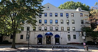
Lanier Heights is a small urban neighborhood located in the northwest section of Washington, D.C. It was one of the early planned subdivisions which were created inside the District of Columbia, but which lay outside of the original, officially planned City of Washington. Situated two miles north of the White House, Lanier Heights is within the larger and newer neighborhood of Adams Morgan, and is usually considered to be a part of that more prominent locale.

New Hampshire Avenue is a diagonal avenue in Washington, D.C., beginning at the Kennedy Center and extending northeast for about 5 miles (8 km) and then continuing into Maryland, where it is designated Maryland Route 650. New Hampshire Avenue is not contiguous. It stops at 15th and W Streets NW, and resumes again on the other side of Columbia Heights at Park Road NW, a few blocks from Georgia Avenue.
Woodley Park is a neighborhood in Washington, D.C., located in Northwest D.C. Primarily residential, Woodley Park hosts a commercial corridor of restaurants and shops located along Connecticut Avenue. The neighborhood is noted as the home of the National Zoological Park, part of the Smithsonian Institution.

Columbia Park is a neighborhood in the Northeast community in Minneapolis. Its boundaries are 37th Avenue NE to the north, Central Avenue to the east, 27th Avenue NE to the south, and both University Avenue & Saint Anthony Parkway streets to the west. It is one of ten neighborhoods in Ward 1 of Minneapolis, currently represented by the Council President, Elliott Payne.

Northeast Boundary is small neighborhood located in the northeast quadrant of Washington, D.C., in the United States. Along with the Capitol View neighborhood, it is the easternmost neighborhood of the District of Columbia.
Manor Park is a neighborhood in Ward 4 of northwest Washington, D.C.

18th Street Northwest is a prominent north–south street thoroughfare in the Northwest quadrant of Washington, D.C.

Sixteenth Street Heights is a large neighborhood of rowhouses, duplexes, and American Craftsman and American Foursquare detached houses in Northwest Washington, D.C.

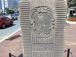
The boundary markers of the original District of Columbia are the 40 milestones that marked the four lines forming the boundaries between the states of Maryland and Virginia and the square of 100 square miles (259 km2) of federal territory that became the District of Columbia in 1801. Working under the supervision of three commissioners that President George Washington had appointed in 1790 in accordance with the federal Residence Act, a surveying team led by Major Andrew Ellicott placed these markers in 1791 and 1792. Among Ellicott's assistants were his brothers Joseph and Benjamin Ellicott, Isaac Roberdeau, George Fenwick, Isaac Briggs and an African American astronomer, Benjamin Banneker.
The Garden Club of America Entrance Markers in Washington, D.C., are carven stone pylons installed along the border of the District of Columbia in 1932 and 1933 by local Garden Club of America chapters. Originally about five feet tall, the markers were placed at important entrance points to the national capital. Seven survive: sets of two markers in Westmoreland Circle, Friendship Heights, and Chevy Chase Circle; and a single marker along Georgia Avenue. These surviving markers are listed on the National Register of Historic Places.

Lincoln Heights is a neighborhood in Spokane, Washington. It is located in the southeastern portion of the city in a broader area commonly known as the South Hill. As the name suggests, Lincoln Heights lies on the slopes and atop the crest of the South Hill area. Lincoln Heights is home to a mix of single-family residential, multi-family residential, and commercial areas and a significant amount of park land. The Lincoln Heights Shopping Center and surrounding area is one of the largest and most important commercial and retail districts on the entire south side of Spokane.

