Sheridan Circle | |
Location | Intersection of Massachusetts Avenue, R Street, and 23rd Street NW Washington, D.C., United States |
---|---|
Coordinates | 38°54′43.8″N77°03′02.4″W / 38.912167°N 77.050667°W |
Part of | Massachusetts Avenue Historic District Sheridan-Kalorama Historic District |
NRHP reference No. | 74002166 (Massachusetts Avenue Historic District) 89001743 (Sheridan-Kalorama Historic District) |
Significant dates | |
Added to NRHP | October 22, 1974 (Massachusetts Avenue Historic District) October 30, 1989 (Sheridan-Kalorama Historic District) |
Designated DCIHS | November 27, 1973 (Massachusetts Avenue Historic District) August 16, 1989 (Sheridan-Kalorama Historic District) |
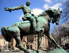
Sheridan Circle is a traffic circle and park in the Sheridan-Kalorama neighborhood of Washington, D.C. The traffic circle, one of two in the neighborhood, is the intersection of 23rd Street NW, Massachusetts Avenue NW, and R Street NW. The buildings along this stretch of Massachusetts Avenue NW are part of Embassy Row, which runs from Scott Circle to Observatory Circle. Sheridan Circle is a contributing property to the Massachusetts Avenue Historic District and the Sheridan-Kalorama Historic District, both listed on the National Register of Historic Places (NRHP). In addition, the equestrian statue of General Philip Sheridan is 1 of 18 Civil War Monuments in Washington, D.C., that were collectively listed on the NRHP.
The area around Sheridan Circle did not develop until the 1880s-1890s. Local officials extended Massachusetts Avenue NW past what was then the city's boundary, now Florida Avenue, in hopes of recreating the residential success of Dupont Circle. The Sheridan-Kalorama area was previously home to large estates and country homes. These lands were eventually sold and the traffic circle's name was changed from Decatur Circle, in honor of Commodore Stephen Decatur, to Sheridan Circle, in honor of Civil War General Philip Sheridan. It took many years for the equestrian statue of Sheridan to be created, and the dedication of the memorial took place in 1908. By that time, houses were being built around the circle, including the first one, the Alice Pike Barney Studio House.
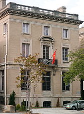
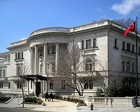
The remaining homes around the circle were elaborate mansions, designed by some of the top local and national architects. During the Great Depression, some of the residences were sold to foreign countries. This occurred again after World War II and into the 1950s. Some of the embassies and ambassadorial residences facing Sheridan Circle include Romania, Ireland, Greece, Vietnam, Kenya, Egypt, South Korea, Latvia, and Turkey.
Two violent moments that occurred at Sheridan Circle were the assassination of Orlando Letelier and Ronni Karpen Moffitt by Chile's Dirección de Inteligencia Nacional. Those that took part in the car bomb attack were Cuban expatriates who supported Chilean dictator Augusto Pinochet. There is a small monument by the circle in honor of the two victims. The other violent moment took place in 2017 when clashes broke out between the Kurdistan Workers' Party (PKK) supporters and Kurdish separatists who were protesting Turkish President Recep Tayyip Erdoğan. The protesters and reporters were beaten by Erdoğan's security detail. The victims later opened a civil case against the Turkish government.
Sheridan Circle, the city's Reservation 57A, is the intersection of 23rd Street NW, Massachusetts Avenue NW, and R Street NW, in the Sheridan-Kalorama neighborhood of Washington, D.C. [1] It is one of two traffic circles in the neighborhood, the other being Kalorama Circle. [2] The circle and its surrounding buildings are contributing properties to two historic districts. The first one, Massachusetts Avenue Historic District, was added to the District of Columbia Inventory of Historic Sites (DCIHS) on November 27, 1973, and listed on the National Register of Historic Places (NRHP) on October 22, 1974. The second is the Sheridan-Kalorama Historic District, added to the DCIHS on August 16, 1989, and listed on the NRHP on October 30, 1989. [3]
The area that now encompasses Sheridan Circle, and much of the present-day Sheridan-Kalorama neighborhood, were originally large estates built outside the city's boundary. Local government officials announced in 1886 that development would be expanded beyond Boundary Street (renamed Florida Avenue in 1890). The plan was to extend Massachusetts Avenue NW northward past Rock Creek. Two traffic circles were also planned in the extension and most of the surrounding area was to be plotted and have streets laid out within a year. [2]
The land that was previously the Lovett estate and the Barlow-Bomford mausoleum is where present-day Sheridan Circle is located. The earliest developments in the Sheridan-Kalorama neighborhood took place near Decatur Circle, the original name of Sheridan Circle. It was named in honor of United States Navy Commodore Stephen Decatur, but renamed in 1890, in honor of Civil War General Philip Sheridan. [2] [4]
Dupont Circle, a neighborhood to the east, became a fashionable residential area in the 1880s. Development past the Dupont Circle boundaries began that same decade, and by 1887, the lots along Massachusetts Avenue had been plotted. Soon, there were large residences being built along the avenue towards Decatur Circle. In the 1890s, the city's boundary was extended past Rock Creek, but city officials had to build a new bridge over the creek and pave Massachusetts Avenue before further development could occur. [2]
The stone bridge that carried people and goods over Rock Creek on Massachusetts Avenue was replaced with an iron bridge in 1901, which was also replaced in the 1940s and named the Charles C. Glover Memorial Bridge. [2] [5] The large residences built along Massachusetts Avenue were designed by prominent architects from Washington, D.C., as well as ones from other major cities. Most of the residences built around Sheridan Circle were free-standing mansions, occupied by prominent members of society. The first house to be constructed that faced the circle was the Alice Pike Barney Studio House, an eclectic example of Spanish Colonial Revival architecture, which Alice Pike Barney used as an art studio and residence. Foreign governments also became interested in building stylish, large embassies around the circle. [2] [6]
A statue to honor General Sheridan was originally proposed to stand on the north side of Pennsylvania Avenue NW near 13th Street NW, at what is now Freedom Plaza. Sheridan's widow advocated to erect the statue at Sheridan Circle instead, with which the statue commission agreed. John Quincy Adams Ward was selected to sculpt the statue. Mrs. Sheridan rejected his original model, saying it was not a good likeness of her husband, and the statue commission rejected Ward's model. The commission and Mrs. Sheridan both approved of a model created by Gutzon Borglum, one that was modeled after Philip Sheridan Jr. [7] [8] The statue and the surrounding park were dedicated on November 27, 1908, and is one of 18 Civil War Monuments in Washington, D.C., listed on the NRHP on September 20, 1978, and the DCIHS on March 3, 1979. [3] [9]
In the years following World War I, there was an explosion in growth of new buildings in the area. Many prominent local and national architects designed palatial residences around Sheridan Circle. During the Great Depression, many of the local residences were sold to foreign nations or various groups. After World War II ended, many of the area residences were renovated into embassies, ambassadorial residences, and attachés. [2]
Examples include the following: the Edward Hamlin Everett House, designed by George Oakley Totten Jr., is the ambassadorial residence for Turkey; the mansion at 2234 Massachusetts Avenue NW, designed by William Penn Cresson, is the Irish embassy; the mansion at 1607 23rd Street NW, designed by Carrère and Hastings, is the Romanian embassy; the Joseph Beale House, designed by Glenn Brown, is the ambassadorial residence for Egypt; 2221 Massachusetts Avenue NW, designed by Totten Jr., is the Greek embassy; the Emma S. Fitzhugh House, designed by Wood, Donn & Deming, is the ambassadorial residence for the Philippines; and 2249 R Street NW, designed by Nathan C. Wyeth, is the ambassadorial residence for Kenya. [2] Additional countries who own buildings on the circle include South Korea (consular section) and Vietnam. The American Society of International Law's headquarters is on the east side of the circle at 2223 Massachusetts Avenue NW. [2] [4]
On September 21, 1976, Orlando Letelier and Ronni Karpen Moffitt were killed by a car bomb in the circle. Letelier had been foreign minister in the ousted Allende government of Chile. The bombing was blamed on Chilean DINA agents. Michael Townley, a DINA U.S. expatriate among those convicted for the crime, confessed that he had hired five anti-Castro Cuban exiles to booby-trap Letelier's car. According to Jean-Guy Allard, after consultations with the Coordination of United Revolutionary Organizations leadership (including Luis Posada Carriles and Orlando Bosch), those selected to carry out the murder were Cuban Americans José Dionisio Suárez, Virgilio Paz Romero, Alvin Ross Díaz, and brothers Guillermo and Ignacio Novo Sampoll. [10] [11]
According to news reports, Luis Posada Carriles was at the meeting that decided on Letelier's death and also about the Cubana bombing two weeks later. [10] Letelier and Moffitt are commemorated with a small plaque embedded in the grass along the curb where they died, near the Irish and Romanian embassies. [11] In 2023, Chilean President Gabriel Boric visited the memorial site where he placed flowers. [12]
On May 16, 2017, dozens of Kurdistan Workers' Party (PKK) supporters and Kurdish separatists clashed with Turkish security officials at Sheridan Circle. [13] Turkish security personnel beat journalists and protesters during the skirmish. [13] Turkish President Recep Tayyip Erdoğan, visiting the ambassadorial residence on the circle, watched the clashes from a distance. [14] During a civil suit by some of the PKK supporters against the Turkish government, a U.S. judge denied Turkey's citing the Foreign Sovereign Immunities Act as to why the case should be dismissed. [13]
Dupont Circle is a historic roundabout park and neighborhood of Washington, D.C., located in Northwest D.C. The Dupont Circle neighborhood is bounded approximately by 16th Street NW to the east, 22nd Street NW to the west, M Street NW to the south, and Florida Avenue NW to the north. Much of the neighborhood is listed on the National Register of Historic Places. However, the local government Advisory Neighborhood Commission and the Dupont Circle Historic District have slightly different boundaries.
Embassy Row is the informal name for a section of Northwest Washington, D.C., with a high concentration of embassies, diplomatic missions, and diplomatic residences. It spans Massachusetts Avenue N.W. between 18th and 35th street, bounded by Scott Circle to the south and the United States Naval Observatory to the north; the term is often applied to nearby streets and neighborhoods that also host diplomatic buildings, such as Kalorama.
Northwest is the northwestern quadrant of Washington, D.C., the capital of the United States, and is located north of the National Mall and west of North Capitol Street. It is the largest of the four quadrants of the city, and it includes the central business district, the Federal Triangle, and the museums along the northern side of the National Mall, as well as many of the District's historic neighborhoods.
The South African Embassy in Washington, D.C. is the diplomatic mission of the Republic of South Africa to the United States. It is located at 3051 Massachusetts Avenue, Northwest, Washington, D.C. in the Embassy Row neighborhood.
Massachusetts Avenue is a major diagonal transverse road in Washington, D.C., and the Massachusetts Avenue Historic District is a historic district that includes part of it.
Thomas Circle is a traffic circle in Northwest Washington, D.C., United States. It is located at the intersection of 14th Street, M Street, Massachusetts Avenue, and Vermont Avenue NW. A portion of Massachusetts Avenue travels through a tunnel underneath the circle. The interior of the circle includes the equestrian statue of George Henry Thomas, a Union Army general in the Civil War.
Charles Evans Hughes House is a historic house at 2223 R Street, NW in the Sheridan-Kalorama neighborhood of Washington, D.C. Built in 1907, it was from 1930 to 1948 the home of Charles Evans Hughes (1862–1948), a prominent Republican politician and from 1930 to 1941 the Chief Justice of the United States. It was declared a National Historic Landmark in 1972 and is a contributing property to the Sheridan-Kalorama Historic District. It presently serves as the official residence of the Ambassador of Myanmar to the United States.
The Sixteenth Street Historic District is a 1.25-mile (2.01 km) linear historic district in Washington, D.C., that includes all structures along 16th Street NW between H Street and Florida Avenue. The district's southern boundary is bordered by Lafayette Square, just north of the White House, and Meridian Hill Park on its northern boundary. It includes an eclectic mix of architectural styles on one of the city's most historic and important numbered streets including single and multi-family residential buildings, embassies, hotels, churches, and office buildings.
The Embassy of Australia in Washington, D.C. is the diplomatic mission of the Commonwealth of Australia to the United States. The chancery is located at 1601 Massachusetts Avenue NW on Scott Circle, at the beginning of Embassy Row. The current ambassador is former Prime Minister Kevin Rudd and the Deputy Head of Mission is Paul Myler. The embassy employs more than 250 people.
The Embassy of Turkey in Washington, D.C. is the diplomatic mission of the Republic of Turkey to the United States. It is located at 2525 Massachusetts Avenue, Northwest in the Embassy Row neighborhood.
General Philip Sheridan is a bronze sculpture that honors Civil War general Philip Sheridan. The monument was sculpted by Gutzon Borglum, best known for his design of Mount Rushmore. Dedicated in 1908, dignitaries in attendance at the unveiling ceremony included President Theodore Roosevelt, members of the President's cabinet, high-ranking military officers and veterans from the Civil War and Spanish–American War. The equestrian statue is located in the center of Sheridan Circle in the Sheridan-Kalorama neighborhood of Washington, D.C. The bronze statue, surrounded by a plaza and park, is one of eighteen Civil War monuments in Washington, D.C., which were collectively listed on the National Register of Historic Places in 1978. The sculpture and surrounding park are owned and maintained by the National Park Service, a federal agency of the Interior Department.
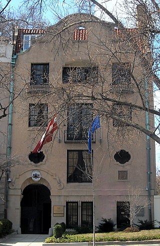
The Embassy of Latvia in Washington, D.C., is the diplomatic mission of the Republic of Latvia to the United States. It is located at 2306 Massachusetts Avenue NW on Embassy Row in the Sheridan-Kalorama neighborhood.
The French ambassador's residence in Washington, D.C. is located at 2221 Kalorama Road, N.W., in the Kalorama neighborhood of Northwest Washington, D.C.
The Embassy of Kenya in Washington, D.C. is the Republic of Kenya's diplomatic mission to the United States, located in the Kalorama neighborhood at 2249 R Street Northwest, Washington, D.C. It is headed by Lazarus O. Amayo.
The Kalorama Triangle Historic District is a mostly residential neighborhood and a historic district in the northwest quadrant of Washington, D.C. The entire Kalorama Triangle neighborhood was listed on the District of Columbia Inventory of Historic Sites (DCIHS) and National Register of Historic Places (NRHP) in 1987. In addition to individually listed landmarks in the neighborhood, the district is home to roughly 350 contributing properties. The neighborhood is roughly bounded by Connecticut Avenue to the west, Columbia Road to the east, and Calvert Street on the north.
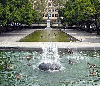
Rawlins Park is a rectangular public park in the Foggy Bottom neighborhood of Washington, D.C., two blocks west of the White House grounds and two blocks north of the National Mall. The boundaries of the park are 18th Street NW to the east, E Street NW to the south and north, and 19th Street NW to the west. The park was an undeveloped open space for many years, until plans were made to install the statue of John Aaron Rawlins in 1874. Various improvements were made, but the area surrounding the park remained mostly undeveloped. This changed in the 1890s when the area was cleared of marshes, and houses were built on the park's southern border.
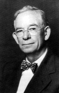
Arthur B. Heaton was an American architect from Washington, D.C. During his 50-year career Heaton designed over 1,000 commissions, including many notable buildings listed on the National Register of Historic Places (NRHP). He was the first supervising architect of the Washington National Cathedral and one of several local architects responsible for designing many of the buildings in the Burleith, Cleveland Park, Kalorama Triangle, and Woodley Park neighborhoods.
Appleton Prentiss Clark Jr. was an American architect from Washington, D.C. During his 60-year career, Clark was responsible for designing hundreds of buildings in the Washington area, including homes, hotels, churches, apartments and commercial properties. He is considered one of the city's most prominent and influential architects from the late 19th and early 20th centuries. Many of his designs are now listed on the National Register of Historic Places (NRHP).
The Sheridan-Kalorama Historic District is a neighborhood and historic district located in the northwest quadrant of Washington, D.C. The boundaries of the historic district include Rock Creek Park to the north and west, P Street to the south, and 22nd Street and Florida Avenue to the east. On the southwestern edge of the neighborhood is a stretch of Embassy Row on Massachusetts Avenue. The other neighborhood and historic district that lies to the east of Sheridan-Kalorama is Kalorama Triangle Historic District. The two neighborhoods are divided by Connecticut Avenue. For many years both neighborhoods were geographically connected before the stretch of Connecticut Avenue was installed toward the Taft Bridge. Oftentimes, both neighborhoods are simply called "Kalorama" or "Kalorama Heights".
Daniel Boone Clarke Waggaman was an architect, designer, and lawyer. He designed residences, apartments, commercial buildings, townhouses, and country estates throughout America, most notably the Washington, D.C., districts: Dupont Circle, Sheridan Kalorama, Massachusetts Ave. Heights, West End, and Connecticut Ave.
{{cite web}}
: CS1 maint: multiple names: authors list (link){{cite book}}
: CS1 maint: multiple names: authors list (link){{cite news}}
: CS1 maint: multiple names: authors list (link)