
The National Mall is a landscaped park near the downtown area of Washington, D.C., the capital city of the United States. It contains and borders a number of museums of the Smithsonian Institution, art galleries, cultural institutions, and various memorials, sculptures, and statues. It is administered by the National Park Service (NPS) of the United States Department of the Interior as part of the National Mall and Memorial Parks unit of the National Park System. The park receives approximately 24 million visitors each year.

Dupont Circle is a historic roundabout park and neighborhood of Washington, D.C., located in Northwest D.C. The Dupont Circle neighborhood is bounded approximately by 16th Street NW to the east, 22nd Street NW to the west, M Street NW to the south, and Florida Avenue NW to the north. Much of the neighborhood is listed on the National Register of Historic Places. However, the local government Advisory Neighborhood Commission and the Dupont Circle Historic District have slightly different boundaries.

L'Enfant Plaza is a complex of four commercial buildings grouped around a large plaza in the Southwest section of Washington, D.C., United States. Immediately below the plaza and the buildings is La Promenade shopping mall.

Meridian Hill Park, also informally known as Malcolm X Park, is an urban park in Washington, D.C., located in the neighborhood of Columbia Heights in Northwest D.C. The park was built between 1912-40 and covers 12-acre (49,000 m2). Meridian Hill Park is bordered by 15th, 16th, W, and Euclid streets NW, and sits on a prominent hill 1.5 miles (2.4 km) directly north of the White House. Since 1969, the name "Malcolm X Park" has been used by many in honor of Malcolm X.

Mount Vernon Square is a city square and neighborhood in the Northwest quadrant of Washington, D.C. The square is located where the following streets would otherwise intersect: Massachusetts Avenue NW, New York Avenue NW, K Street NW, and 8th Street NW.

16th Street Northwest, briefly known as the Avenue of the Presidents, is a prominent north-south boulevard in Washington, D.C., located in Northwest D.C. The street was laid out as part of the 1791 L'Enfant Plan, which served as the original blueprint for the city. The street begins just north of the White House, across from Lafayette Square in the President's Park, and continues north along the Washington meridian until Blair Circle.

Freedom Plaza, originally known as Western Plaza, is an open plaza in Northwest Washington, D.C., United States, located near 14th Street and Pennsylvania Avenue NW, adjacent to Pershing Park. The plaza features an inlay that partially depicts Pierre (Peter) Charles L'Enfant's plan for the City of Washington. The National Park Service administers the Plaza as part of its Pennsylvania Avenue National Historic Site and coordinates the Plaza's activities.
National Mall and Memorial Parks is an administrative unit of the National Park Service (NPS) encompassing many national memorials and other areas in Washington, D.C. Federally owned and administered parks in the capital area date back to 1790, some of the oldest in the United States. In 1933, they were transferred to the control of the National Park Service. These parks were known as the National Capital Parks from their inception until 1965. The NPS now operates multiple park groupings in the D.C. area, including National Capital Parks-East, Rock Creek Park, President's Park, and George Washington Memorial Parkway. National Mall and Memorial Parks also provides technical assistance for the United States Navy Memorial.

Penn Quarter, often referred to as Old Downtown, is a historic neighborhood of Downtown Washington, D.C., located north of Pennsylvania Avenue, in Northwest D.C. Penn Quarter is roughly equivalent to the city's early downtown core near Pennsylvania Avenue and 7th Street NW, Penn Quarter is an entertainment and commercial hub, home to many museums, theaters, cinemas, restaurants, bars, art galleries and retail shops. Landmarks include the Capital One Arena, the National Portrait Gallery, and the Harman Center for the Arts, among others. The area is also home to a popular farmers market and several food, wine, art, and culture focused festivals.

Franklin Square is one of the five original open-space parks planned by William Penn when he laid out the city of Philadelphia, Pennsylvania, United States in 1682. It is located in the Center City area, between North 6th and 7th Streets, and between Race Street and the Vine Street Expressway (I-676).

Downtown is the central business district of Washington, D.C., located in Northwest D.C. It is the fourth largest central business district in the United States. The "Traditional Downtown" has been defined as an area roughly between Union Station in the east and 16th Street NW in the west, and between the National Mall on the south and Massachusetts Avenue on the north, including Penn Quarter. However, nowadays, Downtown D.C. usually refers to a larger area, as the DC Office of Planning states:
…most residents, workers, and visitors think of Downtown in a broader sense — including areas as far north as Dupont Circle, as far west as Foggy Bottom, and as far east as Capitol Hill. Only about half of the central city workforce is located within the city’s traditional Downtown.


Washington Harbour is a Class-A mixed-use development located at 3000 and 3050 K Street, N.W., in Washington, D.C., in the United States. The southern edge of the development borders the Potomac River on the Georgetown waterfront. Designed by Arthur Cotton Moore, the complex consists of two curved towers and three other buildings attached to them, all of which are in the Postmodern architectural style. The complex contains luxury condominia, offices, retail space, restaurants, and underground parking.

The Sixteenth Street Historic District is a 1.25-mile (2.01 km) linear historic district in Washington, D.C., that includes all structures along 16th Street NW between H Street and Florida Avenue. The district's southern boundary is bordered by Lafayette Square, just north of the White House, and Meridian Hill Park on its northern boundary. It includes an eclectic mix of architectural styles on one of the city's most historic and important numbered streets including single and multi-family residential buildings, embassies, hotels, churches, and office buildings.

1111 Pennsylvania Avenue is a mid-rise Postmodern office building located in Washington, D.C., in the United States. It is 180 feet (55 m) tall, has 14 stories, and has a four-story underground parking garage. It is a "contributing" resource to the Pennsylvania Avenue National Historic Site.
Vlastimil Koubek was a Czech American architect who designed more than 100 buildings, most of them in the Washington, D.C., metropolitan area. When he died, he had designed buildings worth more than $2 billion. Most of his work is Modernist in style, although he developed a few structures in other vernaculars. He created the site plan for the redevelopment of Rosslyn, Virginia, and his Ames Center anchored the area's economic recovery. He also designed the World Building in Silver Spring, Maryland, which sparked redevelopment of that town's downtown and the L'Enfant Plaza Hotel in Washington, D.C., amongst many other buildings. In 1985, Washingtonian magazine considered him to be one of 20 people "who in the past 20 years had the greatest impact on the way we live and who forever altered the look of Washington." In 1988, The Washington Post newspaper said his Willard Hotel renovation was one of 28 projects in the area which made a signal contribution to the "feel" and look of Washington, D.C.
The Dupont Circle Fountain, formally known as the Rear Admiral Samuel Francis Dupont Memorial Fountain, is a fountain located in the center of Dupont Circle in Washington, D.C. It honors Rear Admiral Samuel Francis Du Pont, a prominent American naval officer and member of the Du Pont family. The fountain replaced a statue of Du Pont that was installed in 1884. Designed by Henry Bacon and sculpted by Daniel Chester French, the fountain was dedicated in 1921. Prominent guests at the dedication ceremony included First Lady Florence Harding, Secretary of War John W. Weeks and Secretary of the Navy Edwin Denby.

CityCenterDC, sometimes colloquially called CityCenter, is a mixed-use development consisting of two condominium buildings, two rental apartment buildings, two office buildings, a luxury hotel, and public park in downtown Washington, D.C. It encompasses 2,000,000 square feet (190,000 m2) and covers more than five city blocks. The $950 million development began construction on April 4, 2011, on the site of the former Washington Convention Center—a 10.2-acre (4.1 ha) site bounded by New York Avenue NW, 9th Street NW, H Street NW, and 11th Street NW. Most of the development was completed and open for business by summer 2015. The luxury hotel Conrad Washington, DC, opened in February 2019.

The Hamilton Hotel is a AAA 4-diamond hotel in downtown Washington, D.C., United States, located at 1001 14th Street, N.W., just to the north of Franklin Square. It is a member of Historic Hotels of America, the official program of the National Trust for Historic Preservation.
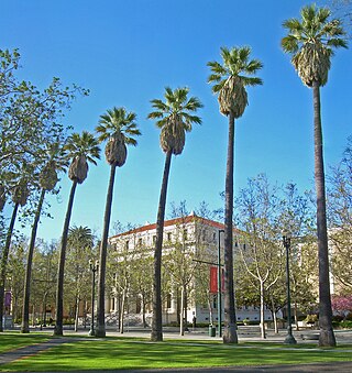
St. James Park is a 6.8-acre (2.8 ha) park in downtown San Jose, California. Originally laid out as St. James Square in 1848, local newspapers dubbed the site a park in 1885, shortly after a fountain was installed in the center of the area. In 1933, two men who were accused of kidnapping and murdering Brooke Hart were lynched in St. James Park. Since then, a road and light rail tracks have been added, bisecting the park; it is now a popular gathering spot for the homeless population of San Jose.


