Oxon Run Parkway

Last updated
Oxon Run Parkway
IUCN category V (protected landscape/seascape)
Map of the Oxon Run Parkway.png
1989 Map showing the Oxon Run Parkway
Location District of Columbia, United States
Coordinates 38°50′17.5″N76°59′5.5″W / 38.838194°N 76.984861°W / 38.838194; -76.984861
Area59 ha (150 acres)
Authorized1926
Governing bodyNational Park Service

The Oxon Run Parkway is a corridor of federal park land in the Washington Highlands neighborhood of Washington, D.C. The Parkway once extended across the District's southern corner in a crescent from Hillcrest Heights to Oxon Hill but most of it became Oxon Run Park in 1971, and now only the portion north of 13th Street still uses the Parkway name. It was originally intended to provide recreation space, but was later enlarged to provide flood relief, space for a major piece of sewer infrastructure and the possibility of a clean drinking water source.

Contents

At one time there was to be a road within it, but the road was dropped from the plans. The remaining Parkway is now 146 acres (59 ha). [1] [2] 94 acres (38 ha) of the existing site were originally a portion of the Camp Simms rifle range. What remains of the Parkway sits between Southern Avenue, Mississippi Avenue and 13th Street, SE and is now managed by the National Park Service. It contains wetlands, floodplains, springs, and forests as well as the only remaining McAteen magnolia bogs in the District of Columbia. [3]

Proposed road

Part of the parkway road was built in Hillcrest Heights, Maryland but the name was later changed to Oxon Run Drive. In 1942, a section of Oxon Run Parkway in Dillon Park, Maryland was renamed to 53rd Avenue. [4] It was later, after 1981, renamed Dewitt Avenue. A short road in District Heights, Maryland, off Scott Key Drive is the only road that still uses the Oxon Run Parkway name.

In 1946, the NCPPC voted to change the name of several parkways including Oxon Run Parkway to just "parks" because they did not contain a road through the middle; but the name "Oxon Run Parkway" remained in popular use and outlived the change. [5]

History

The Oxon Run Parkway was created by the National Capital Park and Planning Commission (NCPPC) to provide park space to the people of Washington, to allow for the construction of a sewer main and to prevent construction in the floodplain. In 1924, Congress created the NCPPC to create a park and playground system for the National Capital and by 1926, they had begun making plans for a "parkway" or park system that would include land along the Anacostia, at Fort Dupont, along Foundry Branch and along Oxon Run. [6] By 1930, NCPPC had begun purchasing narrow strips of land along the shores of the stream for the park. This coincided with a report from NCPPC identifying Oxon Run as a possible water source for Maryland. The report stated that a sewer would be needed through the valley to protect the waters of Oxon Run from pollution. [7] After a 1937 flood, NCPPC decided to purchase 144 additional acres of land in the valley from the District line to the Camp Simms rifle range north of 14th. The land would widen the Parkway above the high water mark, thus preventing the construction of homes that might be prone to flooding. It also allowed for the construction of the sewer project, the Oxon Run interceptor, that was completed in 1939. [8] [9] [10] Expansion continued as 40 acres (16 ha) were purchased in 1939 and another 64 in 1940, bringing the total to 137. [11] [12] Small additional purchases, of more than 11 acres (4.5 ha), were made later in 1940 and in 1941, and then in 1942 a further 20 acres (8.1 ha) were acquired. [13] [14] [15] [16] [17] Another 2.5 acres (1.0 ha) were purchased in 1944 as the 8-year long Oxon Run Parkway and flood control project wrapped up its work. [18] At this point the Parkway extended across the entire District, with the exception of the portion within Camp Simms.

In 1946, President Truman signed an amendment to the Capper-Crampton Act which, among other things, called for the Parkway to be extended into Maryland from the District Line to Marlboro Pike (then known as Marlboro Road). [19] This extension, however, was carried out by the Maryland-National Capital Park and Planning Commission and was never part of the Parkway, nor did it ever extend past the Suitland Parkway.

In 1951, NCPPC began work on transferring some of the Camp Simms Firing Range, an irregularly shaped plot located between Alabama Avenue, Southern Avenue, 13th and Valley Terrace to the National Park Service. The portion they sought for the park was between Mississippi Ave and Valley Avenue, as the Parkway already included the land on both sides of the rifle range. [20] [21] The range had been in use since 1904, but by 1953 it no longer was and the District was making plans to extend a highway through the area, with one lane on each side of the run. [22] In 1958, the Defense Department transferred the land to the General Services Administration and later 94 acres (38 ha) of the site was added to the parkway. [23] In July 1994, while digging wells in preparation for the Green Line tunnel, Metro discovered 6 Stokes mortar rounds, prompting the U.S. Army Corps of Engineers (COE) to begin a clean-up of the site. By the end of 1995 they had found 30 pieces of live ammunition, and by the end of 1997 a total of 74 pieces. The clean-up took two years and delayed construction of the Green Line tunnel beneath the Parkway. [24] Following the clean-up, the National Park Service and the USDA National Resource Conservation Service (NRCS) performed an ecological restoration of Oxon Run within the Parkway, stabilizing the soil with jute mating and planting new plants. They also restored the old rifle range, which contained lead-contaminated soils and old shell casings left from years of target practice, by covering it with new top soil. Work was completed in January 2000. [23] [25]

NCPPC began divesting itself of the land it had acquired as early as 1942 when it turned over the Oxon Run Recreation Center, between Mississippi and Valley Avenue & 4th and 6th Streets, to the then newly formed District Recreation Board. [26] In 1971, NCPC transferred 300 acres (120 ha) of federal parkland from the National Park Service to the District government, part of a larger 700-acre (280 ha) transfer, including Watts Branch, Pope Branch and most of the Oxon Run Parkway. The transferred land along Oxon Run became Oxon Run Park. [27] Other plots were handed over for schools and for an arts recreation center.

See also

Related Research Articles

<span class="mw-page-title-main">Prince George's County, Maryland</span> County in Maryland, United States

Prince George's County is located in the U.S. state of Maryland bordering the eastern portion of Washington, D.C. As of the 2020 U.S. census, the population was 967,201, making it the second-most populous county in Maryland, behind neighboring Montgomery County. The 2020 census counted an increase of nearly 104,000 in the previous ten years. Its county seat is Upper Marlboro. It is the largest and the second most affluent African American-majority county in the United States, with five of its communities identified in a 2015 top ten list.

<span class="mw-page-title-main">Suitland, Maryland</span> Census-designated place in Maryland, United States

Suitland is a suburb of Prince George's County, Maryland, approximately one mile (1.6 km) southeast of Washington, D.C. Suitland is a census designated place (CDP), as of the 2020 census, its population was 25,839. Prior to 2010, it was part of the Suitland-Silver Hill census-designated place.

<span class="mw-page-title-main">Congress Heights</span> Neighborhood in Washington, D.C., U.S.

Congress Heights is a residential neighborhood in Southeast Washington, D.C., in the United States. The irregularly shaped neighborhood is bounded by the St. Elizabeths Hospital campus, Lebaum Street SE, 4th Street SE, and Newcomb Street SE on the northeast; Shepard Parkway and South Capitol Street on the west; Atlantic Street SE and 1st Street SE on the south; Oxon Run Parkway on the southeast; and Wheeler Street SE and Alabama Avenue SE on the east. Commercial development is heavy along Martin Luther King, Jr. Avenue and Malcolm X Avenue.

<span class="mw-page-title-main">Interstate 295 (Maryland–District of Columbia)</span> Highway in the Washington DC area

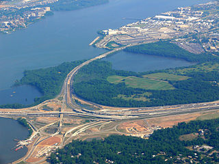
Interstate 295 (I-295) in the US state of Maryland and in Washington, D.C., also known as the Anacostia Freeway, is a six-mile (9.7 km) auxiliary Interstate Highway connecting I-95/I-495 and Maryland Route 210 near the Potomac River to I-695 and District of Columbia Route 295 (DC 295) in the Anacostia neighborhood of Washington, D.C.

<span class="mw-page-title-main">Sligo Creek Trail</span> Paved hiker/biker trail along Sligo Creek in Maryland

Sligo Creek Trail is a paved hiker-biker trail running along Sligo Creek in the suburbs of Washington, D.C. Most of the trail passes through tree-filled parkland. The trail and surrounding park is a popular place for locals to jog, walk, bicycle, roller-skate, and take their children to the playground. Many local families enjoy picnicking at one of the 15 picnic areas along the trail.

<span class="mw-page-title-main">Oxon Creek</span> River in D.C., United States

Oxon Creek is a stream on the Potomac River which feeds a cove that straddles the border between Washington, D.C., and Prince George's County, Maryland just north of Interstate 495 at Woodrow Wilson Bridge. Oxon Creek heads at the confluence of Oxon Run and Barnaby Run, sometimes referred to as Winkle Doodle Run. It starts just inside the boundary of D.C. and then runs 1.5 miles (2.4 km) to the south and west into Maryland to empty into the Potomac at Goose Island across from the city of Alexandria, Virginia. Before reaching the Potomac, the creek widens to form Oxon Cove which is partially in Maryland and partially in Washington, D.C. The creek is almost entirely within Oxon Cove National Park, except for the first few feet in D.C. and a portion of the cove on the southside of the Blue Plains Advanced Wastewater Treatment Plant.

<span class="mw-page-title-main">Bellevue (Washington, D.C.)</span> Neighborhood in District of Columbia, Washington, United States

Bellevue is a residential neighborhood in far Southeast and Southwest in Washington, D.C., United States. It is bounded by South Capitol Street, one block of Atlantic Street SE, and 1st Streets SE and SW to the north and east; Joliet Street SW and Oxon Run Parkway to the south; Martin Luther King Jr. Avenue SE, Shepherd Parkway, 2nd Street SW, and Xenia Street SW to the west. Bellevue was created from some of the earliest land patents in Maryland, and draws its name from a 1795 mansion built in the area. Subdivisions began in the 1870s, but extensive residential building did not occur until the early 1940s. Bellevue is adjacent to a number of federal and city agency buildings.

<span class="mw-page-title-main">Washington Highlands (Washington, D.C.)</span> Residential neighborhood, southeast Washington, D.C., United States

Washington Highlands is a residential neighborhood in Southeast Washington, D.C., in the United States. It lies within Ward 8.

<span class="mw-page-title-main">Marshall Heights (Washington, D.C.)</span> Residential neighborhood in Washington, D

Marshall Heights is a residential neighborhood in Southeast Washington, D.C. It is bounded by East Capitol Street, Central Avenue SE, Southern Avenue, Fitch Street SE, and Benning Road SE. It was an undeveloped rural area occupied by extensive African American shanty towns, but the neighborhood received nationwide attention after a visit by First Lady Eleanor Roosevelt in 1934, which led to extensive infrastructure improvements and development for the first time. In the 1950s, Marshall Heights residents defeated national legislation designed to raze and redevelop the neighborhood. Queen Elizabeth II of the United Kingdom visited the area in 1991, at a time when Marshall Heights was in the throes of a violent crack cocaine epidemic. Limited redevelopment has occurred in the neighborhood, which was the site of two notorious child murders in 1973.

<span class="mw-page-title-main">Surratt House Museum</span> Historic house in Maryland, United States

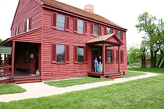
The Surratt House is a historic house and house museum located at 9110 Brandywine Road in Clinton, Prince George's County, Maryland, United States. The house is named for John and Mary Surratt, who built it in 1852. Mary Surratt was hanged in 1865 for being a co-conspirator in the Abraham Lincoln assassination. It was acquired by the Maryland-National Capital Park and Planning Commission (M-NCPPC) in 1965, restored, and opened to the public as a museum in 1976.

<span class="mw-page-title-main">Little Falls Branch (Potomac River tributary)</span> Stream in Maryland, United States of America

Little Falls Branch, a 3.8-mile-long (6.1 km) tributary stream of the Potomac River, is located in Montgomery County, Maryland. In the 19th century, the stream was also called Powder Mill Branch. It drains portions of Bethesda, Somerset, Friendship Heights, and Washington, D.C., flows under the Chesapeake and Ohio Canal (C&O), and empties into the Potomac at Little Falls rapids, which marks the upper end of the tidal Potomac.

<span class="mw-page-title-main">Anacostia Tributary Trail System</span> Hiking trail in Maryland

The Anacostia Tributary Trail System (ATTS) is a unified and signed system of stream valley trails joining trails along the Anacostia tributaries of Northwest Branch, Northeast Branch, Indian Creek and Paint Branch with a trail along the Anacostia River, set aside and maintained by the Maryland-National Capital Park and Planning Commission (M-NCPPC) in the Maryland suburbs of Washington, D.C.

<span class="mw-page-title-main">Utica Parks and Parkway Historic District</span> Historic district in New York, United States

Utica Parks and Parkway Historic District is a national historic district located at Utica in Oneida County, New York. It consists of four contributing historic elements: a historic right-of-way known as the Memorial Parkway and the three large parks it connects: Roscoe Conkling Park, F.T. Proctor Park, and T.R. Proctor Park. The district includes seven contributing buildings, three contributing sites, 26 contributing structures, and five contributing objects. The park and parkway system was designed between 1908 and 1914 by the firm of Olmsted Brothers Landscape Associates, headed by Frederick Law Olmsted Jr. The Utica Zoo is located in Roscoe Conkling Park.

Shepherd Parkway is part of the Civil War Defenses of Washington. It includes two forts, of which some remains still exist. The parkway runs along the high ground opposite the Anacostia Freeway from Joint Base Anacostia–Bolling in the District of Columbia. Shepherd Parkway is bordered on the north by St. Elizabeths Campus and the District of Columbia neighborhoods of Congress Heights and Bellevue and on the south by Bald Eagle Hill.

<span class="mw-page-title-main">New York Avenue Bridge (Anacostia River)</span> Bridge in D.C., U.S.

The New York Avenue Bridge is a bridge carrying U.S. Route 50 and New York Avenue NE over the Anacostia River in Washington, D.C., in the United States. It was completed in 1954 as part of the Baltimore–Washington Parkway project.

<span class="mw-page-title-main">Spring Creek Park</span> Public park in New York City

Spring Creek Park is a public park along the Jamaica Bay shoreline between the neighborhoods of Howard Beach, Queens, and Spring Creek, Brooklyn, in New York City. Created on landfilled former marshland, the park is mostly an undeveloped nature preserve, with only small portions accessible to the public for recreation.

<span class="mw-page-title-main">Oxon Run</span> Stream in Maryland, USA

Oxon Run is a tributary stream of Oxon Creek and the Potomac River in Prince George's County, Maryland, and Washington, D.C.

Oxon Run Park is a recreational park in Southeast Washington, D.C., that features sports areas, trails, playgrounds and the Southeast Tennis and Learning Center. The park was created in 1971 from land that was previously part of the federally-controlled Oxon Run Parkway.

<span class="mw-page-title-main">Forest Glen Park, Maryland</span> Neighborhood in Silver Spring, Maryland

Forest Glen Park is an unincorporated community in Montgomery County, Maryland, United States, and a residential neighborhood within the Silver Spring census-designated place. The community is adjacent to Rock Creek, Rock Creek Regional Park, and to the United States Army's Forest Glen Annex.

<span class="mw-page-title-main">Reno (Washington, D.C.)</span> Former mixed-race neighborhood in Washington, D.C., U.S.

Reno was a town and then neighborhood in Washington, D.C. that existed from the 1860s into the mid-twentieth century on the ground that is now Fort Reno Park in the Tenleytown neighborhood. The town's residents were largely African American, which eventually led to its clearance for Fort Reno Park and Alice Deal Middle School. Its original developers referred to it as Reno City, however this name faded from use before the 1920s.

References

  1. "Magnolia Bogs" (PDF). NPS. Retrieved 5 February 2019.
  2. "NATIONAL PARK SERVICE Managed Properties in the District of Columbia" (PDF). GAO. Retrieved 13 February 2019.
  3. "National Capital Parks-East Natural Resource Condition Assessment" (PDF). Retrieved 30 January 2019.
  4. "Renaming of Streets Completed in Dozens of Communities". The Evening Star. 31 July 1942.
  5. "Planners Weigh Move Back to Shopping Center". The Evening Star. 22 March 1946. Others were Blair, Beach, Pinehurst, Klingle Valley, Normanstone, Watts Branch, Piney Run, Popes Branch and Wesley Heights.
  6. "Planner to seek aid for parkway". The Washington Post. 29 April 1927.
  7. "Schools Progress in Prince George's". The Washington Post. 30 December 1930.
  8. "District Acquires Land for Oxon Run Plant". The Washington Post. 9 June 1931.
  9. "$2,000,000 Is Asked to Extend Parks". The Washington Post. 13 December 1938.
  10. "Park Land Purchases are Discussed as Planners Meet". The Evening Star. 26 January 1939.
  11. "Park Expansion". The Evening Star. 16 September 1939.
  12. "Land Purchase Completed for Oxon Run Park". The Evening Star. 14 November 1940.
  13. "Planners obtain land for two playgrounds". The Evening Star. 19 December 1940.
  14. "Nearly All Land for D.C. Stadium Bought". The Evening Star. 20 February 1941.
  15. "Vast Federal Office Plan Weighed". The Washington Post. 18 April 1941.
  16. "Park Board Approves Sites For Defense". The Washington Post. 23 May 1941.
  17. "Planning Unit Picks Sites for Dormitories". The Washington Post. 17 April 1942.
  18. "Planners Report End of Oxon Run Work". The Evening Star. 3 August 1944.
  19. "CHRONOLOGICAL EVOLUTION OF NATIONAL CAPITAL PARKS LEGISLATION" (PDF). Retrieved 30 January 2019.
  20. "Planners Seek to Keep Veto on D.C. Land Sales". The Evening Star. 14 December 1941.
  21. Darton, N.H (1938). Map Showing Distribution of Gravel and Sand Deposits in and near Washington, D.C. (Map). 1:62,500. Washington: Department of the Interior, U.S. Geological Survey.
  22. "Encroaching Housing Silences Rifle Fire at Camp Simms". The Evening Star. 23 November 1953.
  23. 1 2 Merida, Kevin (13 October 2002). "A Telling Detail; The secret behind the warning on the sign across from the school". The Washington Post.
  24. Jones, Kathy (23 August 1996). "Bombs Away". Washington City Paper. Retrieved 13 February 2019.
  25. "Interagency Cleanup of a former Army Camp at Oxon Run". Park Science. Vol. 19, no. 1. February 1999. Retrieved 14 February 2019.
  26. "Capital Gets 14 More Areas for Recreation". The Evening Star. 17 July 1942.
  27. "G St. Shops Lose Plea for Building on Stilts". The Evening Star. 5 November 1971.