
Rock Creek Park is a large urban park that bisects the Northwest quadrant of Washington, D.C. Created by Act of Congress in 1890, the park comprises 1,754 acres, generally along Rock Creek, a tributary of the Potomac River.
Beatrix Cadwalader Farrand was an American landscape gardener and landscape architect. Her career included commissions to design about 110 gardens for private residences, estates and country homes, public parks, botanic gardens, college campuses, and the White House. Only a few of her major works survive: Dumbarton Oaks in Washington, D.C., the Abby Aldrich Rockefeller Garden on Mount Desert, Maine, the restored Farm House Garden in Bar Harbor, the Peggy Rockefeller Rose Garden at the New York Botanical Garden, and elements of the campuses of Princeton, Yale, and Occidental.

Georgetown is a historic neighborhood and commercial district in Northwest Washington, D.C., situated along the Potomac River. Founded in 1751 as part of the colonial-era Province of Maryland, Georgetown predated the establishment of Washington, D.C. by 40 years. Georgetown was an independent municipality until 1871 when the United States Congress created a new consolidated government for the entire District of Columbia. A separate act, passed in 1895, repealed Georgetown's remaining local ordinances and renamed Georgetown's streets to conform with those in Washington, D.C.

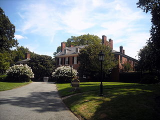
Dumbarton Oaks, formally the Dumbarton Oaks Research Library and Collection, is a historic estate in the Georgetown neighborhood of Washington, D.C. It was the residence and gardens of wealthy U.S. diplomat Robert Woods Bliss and his wife Mildred Barnes Bliss. The estate was founded by the Bliss couple, who gave the home and gardens to Harvard University in 1940.

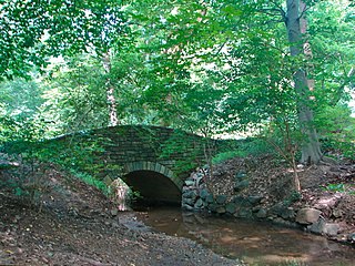
The Dumbarton Bridge, also known as the Q Street Bridge and the Buffalo Bridge, is a historic masonry arch bridge in Washington, D.C.
The Dumbarton Oaks Park is a public park, located in the 3100 block of R Street, Northwest, Washington, D.C., in the Georgetown neighborhood. Access is via Lovers' Lane from R Street, east of 32nd Street. It is located near Dumbarton Oaks, Montrose Park, and Oak Hill Cemetery. It is part of the Georgetown Historic District. Now part of Rock Creek Park, it originally belonged to the Dumbarton Oaks estate which had designed it as an enhanced "natural" area. In the 2020's the National Park Service worked with the estate to restore and preserve the landscape architecture of Beatrix Farrand in the park.

Oak Hill Cemetery is a historic 22-acre (8.9 ha) cemetery located in the Georgetown neighborhood of Washington, D.C., in the United States. It was founded in 1848 and completed in 1853, and is a prime example of a rural cemetery. Many famous politicians, business people, military people, diplomats, and philanthropists are buried at Oak Hill, and the cemetery has a number of Victorian-style memorials and monuments. Oak Hill has two structures which are listed on the National Register of Historic Places: the Oak Hill Cemetery Chapel and the Van Ness Mausoleum.

Dumbarton House is a Federal style house located in the Georgetown neighborhood of Washington, D.C. It was completed around 1800. Its first occupant was Joseph Nourse, the first Register of the Treasury. Dumbarton House, a federal period historic house museum, stands on approximately an acre of gardens on the northern edge of Georgetown, District of Columbia. The house is listed on the National Register of Historic Places. Displaying a fine collection of period decorative arts, it gives the visitor a concrete sense of a substantial private residence in the early 1800s. Constructed in 1798–99, the house was a private residence until The National Society of The Colonial Dames of America (NSCDA) purchased it for its headquarters in 1928 and gave it the name it has today. In addition to meeting its administrative needs, the NSCDA wanted to illustrate domestic life in Georgetown in the early federal period. To achieve this, its two principal floors were opened to the public as a house museum in 1932, on the 200th anniversary of the birth of George Washington.
This is a list of properties and districts in Washington, D.C., on the National Register of Historic Places. There are more than 600 listings, including 74 National Historic Landmarks of the United States and another 13 places otherwise designated as historic sites of national importance by Congress or the President.

Fort DeRussy was an American Civil War-era fortification constructed in 1861 on a hilltop along the west bank of Rock Creek within Washington, D.C., as part of the Defenses of Washington.

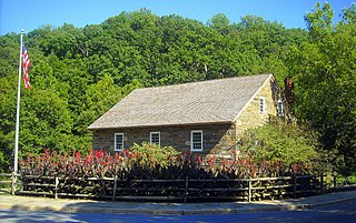
The Old Stone House is one of the oldest structures in Washington, D.C. The house is also the last pre-revolutionary colonial building in Washington, D.C. Built in 1765, Old Stone House is located at 3051 M Street, Northwest in the city's Georgetown neighborhood. Sentimental local folklore preserved the Old Stone House from being demolished, unlike many colonial homes in the area that were replaced by redevelopment.

The Oak Hill Cemetery Chapel, also known as the Renwick Chapel or James Renwick Chapel, is a historic building in the Georgetown neighborhood of Washington, D.C., United States. Designed by James Renwick Jr. in 1850, Oak Hill Cemetery Chapel is the architect's only known example of Gothic Revival church architecture in Washington, D.C. It is located on the highest ridge in Oak Hill Cemetery, near the intersection of 29th and R Streets NW. The chapel is one of two structures in Oak Hill Cemetery listed on the National Register of Historic Places, the other being the Van Ness Mausoleum. The chapel, mausoleum, and cemetery are contributing properties to the Georgetown Historic District, a National Historic Landmark.

Battery Kemble Park is a park in Northwest Washington D.C., administered by the National Park Service.

Prospect House is a historic building, located at 3508 Prospect Street, Northwest, Washington, D.C., in the Georgetown neighborhood.

The Georgetown Market is an historic building constructed in 1865, on the site of a market dating to 1795. It is located at 3276 M Street, Northwest, Washington, D.C., in the Georgetown neighborhood.

Mount Zion Cemetery/Female Union Band Society Cemetery is a historic cemetery located at 27th Street NW and Mill Road NW in the Georgetown neighborhood of Washington, D.C., in the United States. The cemetery is actually two adjoining burial grounds: the Mount Zion Cemetery and Female Union Band Society Cemetery. Together these cemeteries occupy approximately three and a half acres of land. The property fronts Mill Road NW and overlooks Rock Creek Park to the rear. Mount Zion Cemetery, positioned to the East, is approximately 67,300 square feet in area; the Female Union Band Cemetery, situated to the West, contains approximately 66,500 square feet. Mount Zion Cemetery, founded in 1808 as The Old Methodist Burial Ground, was leased property later sold to Mount Zion United Methodist Church. Although the cemetery buried both White and Black persons since its inception, it served an almost exclusively African American population after 1849. In 1842, the Female Union Band Society purchased the western lot to establish a secular burying ground for African Americans. Both cemeteries were abandoned by 1950.
Evermay is a historic Federal architecture-style house at 1623 28th Street, Northwest, Washington, D.C., in the Georgetown neighborhood. The property originally extended south to Q Street, but the other houses were divided from the property.

Western Avenue is one of three boundary streets between Washington, D.C., and the state of Maryland. It follows a southwest-to-northeast line, beginning at Westmoreland Circle in the south and ending at Oregon Avenue NW in the north. It is roughly 3.5 miles (5.6 km) in length. First proposed in 1893, it was constructed somewhat fitfully from about 1900 to 1931.
Gertrude Sawyer was one of the earliest American women architects to practice in Maryland and the Washington, D.C., area.
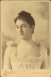
Bertha Noyes (1876–1966) was an American painter.


