Tidewater Lock

Last updated
Tidewater Lock
C and O Tidewater lock and Potomac River.jpg
Waterway Chesapeake and Ohio Canal
CountryUSA
State Washington, D.C.
OperationDefunct
Length54 m
Width4 m
Coordinates 38°54′00″N77°03′28″W / 38.8999°N 77.0578°W / 38.8999; -77.0578 Coordinates: 38°54′00″N77°03′28″W / 38.8999°N 77.0578°W / 38.8999; -77.0578

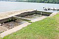
The Tidewater Lock is a dam [1] in Washington, D.C. to the west of the mouth of Rock Creek at the Potomac River, on the east side of Georgetown. Built to connect the Chesapeake and Ohio Canal, opened in 1831, with the Potomac, it was a busy maritime intersection during several decades of the canal's heyday. C&O documents refer to it variously as Lock 0 and Tide Lock A.

Contents

Canal documents sometimes list a "Tide Lock B" on section "I" which stood at the lockhouse at 17th and Constitution Ave NW. It was completed in 1834. [2]

Today, the lock marks Milestone 0 of the National Park Service's Chesapeake & Ohio Canal trail. [3]

See also

Related Research Articles

Paw Paw, West Virginia Town in West Virginia, United States

Paw Paw is a town in Morgan County, West Virginia, United States. The population was 508 in the 2010 census. The town is known for the nearby Paw Paw Tunnel. Paw Paw was incorporated by the Circuit Court of Morgan County on April 8, 1891 and named for the pawpaw, a wild fruit which grows in abundance throughout this region. Paw Paw is the westernmost incorporated community in Morgan County and the Hagerstown-Martinsburg, MD-WV Metropolitan Statistical Area.

Chesapeake and Ohio Canal Canal in Washington, D.C. and Maryland, United States

The Chesapeake and Ohio Canal, abbreviated as the C&O Canal and occasionally called the "Grand Old Ditch," operated from 1831 until 1924 along the Potomac River between Washington, D.C., and Cumberland, Maryland. It replaced the Potomac Canal, which shut down completely in 1828, and could operate during months in which the water level was too low for the former canal. The canal's principal cargo was coal from the Allegheny Mountains.

Paw Paw Tunnel Tunnel in Allegany County, Maryland

The Paw Paw Tunnel is a 3,118-foot-long (950 m) canal tunnel on the Chesapeake and Ohio Canal (C&O) in Allegany County, Maryland. Located near Paw Paw, West Virginia, it was built to bypass the Paw Paw Bends, a six-mile (9.7 km) stretch of the Potomac River containing five horseshoe-shaped bends. The town, the bends, and the tunnel take their name from the pawpaw trees that grow prolifically along nearby ridges.

Chesapeake and Ohio Canal National Historical Park Historic site in Maryland and Washington, D.C.

The Chesapeake and Ohio Canal National Historical Park is located in the District of Columbia and the state of Maryland. The park was established in 1961 as a National Monument by President Dwight D. Eisenhower to preserve the neglected remains of the Chesapeake and Ohio Canal and many of its original structures. The canal and towpath trail extends along the Potomac River from Georgetown, Washington, D.C., to Cumberland, Maryland, a distance of 184.5 miles (296.9 km). In 2013, the path was designated as the first section of U.S. Bicycle Route 50.

The Potomac Heritage Trail, also known as the Potomac Heritage National Scenic Trail or the PHT, is a designated National Scenic Trail corridor spanning parts of the mid-Atlantic and upper southeastern regions of the United States that will connect various trails and historic sites in Virginia, Maryland, Pennsylvania, and the District of Columbia. The trail network includes 710 miles (1,140 km) of existing and planned sections, tracing the outstanding natural, historical, and cultural features of the Potomac River corridor, the upper Ohio River watershed in Pennsylvania and western Maryland, and a portion of the Rappahannock River watershed in Virginia. The trail is managed by the National Park Service.

Rock Creek (Potomac River tributary) Tributary of the Potomac River in Maryland and Washington, D.C., United States

Rock Creek is a free-flowing tributary of the Potomac River that empties into the Atlantic Ocean via the Chesapeake Bay. The 32.6-mile (52.5 km) creek drains about 76.5 square miles (198 km2). Its final quarter-mile is affected by tides.

Patowmack Canal United States historic place

The Patowmack Canal, sometimes called the Potomac Canal, is a series of five inoperative canals located in Maryland and Virginia, United States, that was designed to bypass rapids in the Potomac River upstream of the present Washington, D.C., area. The most well known of them is the Great Falls skirting canal, whose remains are managed by the National Park Service as it is within Great Falls Park Virginia, an integral part of the George Washington Memorial Parkway.

Great Falls (Potomac River) Waterfalls on the Potomac River in Maryland and Virginia

Great Falls is a series of rapids and waterfalls on the Potomac River, 14 miles (23 km) upstream from Washington, D.C., on the border of Montgomery County, Maryland and Fairfax County, Virginia. Great Falls Park, managed as part of George Washington Memorial Parkway, is on the southern banks in Virginia, and Chesapeake and Ohio Canal National Historical Park parkland is along the northern banks of the river in Maryland. Both are operated by the National Park Service. The Potomac and the falls themselves are legally entirely within Maryland, with the state and county boundaries following the south bank of the river.

Washington City Canal

The Washington City Canal operated from 1815 until the mid-1850s in Washington, D.C. The canal connected the Anacostia River, termed the "Eastern Branch" at that time, to Tiber Creek, the Potomac River, and later the Chesapeake and Ohio Canal (C&O). The canal became disused during the late 19th century and the city government covered over or filled in various sections in 1871.

Locks on the Chesapeake and Ohio Canal

The Locks on the Chesapeake and Ohio Canal, located in Maryland, West Virginia, and Washington, D.C. of the United States, were of three types: lift locks; river locks; and guard, or inlet, locks.

Muddy Branch Tributary of the Potomac River in Maryland, United States

Muddy Branch is a tributary stream of the Potomac River in Montgomery County, Maryland, United States, located about 14 miles (23 km) northwest of Washington, D.C.

Seneca, Maryland Unincorporated community in Maryland, United States

Seneca is an unincorporated community in Montgomery County, Maryland, United States. It is located near the intersection of River Road and Seneca Creek, not far from the Chesapeake and Ohio Canal and Potomac River. Its history goes back before the American Revolutionary War and it thrived when the canal was operating—having several warehouses, mills, a store, a hotel, and a school. Fighting occurred in the area on more than one occasion during the American Civil War. The community declined as the C&O Canal declined.

Power Plant and Dam No. 5 (Potomac River) United States historic place

Power Plant and Dam No. 5, also known as Honeywood Dam, comprises a dam on the Potomac River, originally built for the Chesapeake and Ohio Canal, and a power plant built to take advantage of the river's flow to generate hydroelectric power. The dam is included in Chesapeake and Ohio Canal National Historical Park.

R. Paul Smith Power Station former electric generating plant

The R. Paul Smith Power Station is a closed electric generating plant owned by FirstEnergy in Williamsport, Maryland.

Seneca Aqueduct United States historic place

Seneca Aqueduct — or Aqueduct No. 1 — is a naviduct that carries the Chesapeake and Ohio Canal (C&O) over Seneca Creek in Montgomery County, Maryland. The C&O built eleven aqueducts along its 184.5 miles (296.9 km) length. Seneca Aqueduct is a unique structure, not only being the first built, but also the only red sandstone aqueduct on the C&O−and the only aqueduct that is also a lock. It is located at the end of Riley's Lock Road in Seneca, Maryland.

Seneca Dam

Seneca Dam was the last in a series of dams proposed on the Potomac River in the area of the Great Falls of the Potomac. Apart from small-scale dams intended to divert water for municipal use in the District of Columbia and into the Chesapeake and Ohio Canal, no version of any scheme was ever built. In most cases the proposed reservoir would have extended upriver to Harpers Ferry, West Virginia. The project was part of a program of as many as sixteen major dams in the Potomac watershed, most of which were never built.

Pennyfield Lock Lock on the Chesapeake & Ohio Canal in Travilah, Maryland, United States

The Pennyfield Lock and lockhouse are part of the 184.5-mile (296.9 km) Chesapeake and Ohio Canal that operated in the United States along the Potomac River from the 1830s through 1923. The lock, located at towpath mile-marker 19.7, is near River Road in Montgomery County, Maryland. The original lock house was built in 1830, and its lock was completed in 1831.

Swains Lock Lock on the Chesapeake & Ohio Canal in Travilah, Maryland, United States

Swains Lock and lock house are part of the 184.5-mile (296.9 km) Chesapeake and Ohio Canal that operated in the United States along the Potomac River from the 1830s through 1923. It is located at towpath mile-marker 16.7 near Potomac, Maryland, and within the Travilah census-designated place in Montgomery County, Maryland. The lock and lock house were built in the early 1830s and began operating shortly thereafter.

Rileys Lock Lock on the Chesapeake & Ohio Canal in Darnestown, Maryland, United States

Riley's Lock (Lock 24) and lock house are part of the 184.5-mile (296.9 km) Chesapeake and Ohio Canal that operated in the United States along the Potomac River from the 1830s through 1923. They are located at towpath mile-marker 22.7 adjacent to Seneca Creek, in Montgomery County, Maryland. The lock is sometimes identified as Seneca because of the Seneca Aqueduct that carried the canal over the creek to the lift lock. The name Riley comes from John C. Riley, who was lock keeper from 1892 until the canal closed permanently in 1924.

Violettes Lock

Violette's Lock is part of the 184.5-mile Chesapeake and Ohio Canal that operated in the United States along the Potomac River from the 1830s through 1923. It is located at towpath mile-marker 22.1, in Montgomery County, Maryland. The name Violette comes from Alfred L. "Ab" Violette and his wife Kate, who were lock keepers from the beginning of the 20th century through the permanent closure of the canal in 1924.

References

  1. "Tidewater Lock". Geographic Names Information System . United States Geological Survey . Retrieved January 26, 2014.
  2. Unrau, Harlan D. (2007). Historic Resource Study: Chesapeake & Ohio Canal (PDF). Hagerstown, Md.: U.S. Department of the Interior, National Park Service, Chesapeake & Ohio Canal National Historical Park. p. 213. LCCN   2007473571.
  3. "C&O Canal Maps". Chesapeake & Ohio Canal. National Park Service. Retrieved October 30, 2016.